
FLEX Bus Route Map
View the FLEX route map and see all FLEX stops along the route. The map of FLEX shows where the bus travels and the location of each stop, making it easy to understand the entire route at a glance.
Explore Cape Cod Regional Transit Authority routes on the map and see where Cape Cod Regional Transit Authority bus services operate. Use the FLEX map to find bus stops and see how the FLEX connects different areas along its trip.
All FLEX stops on the map are displayed in route order, helping you follow the FLEX bus from the first stop to the last.
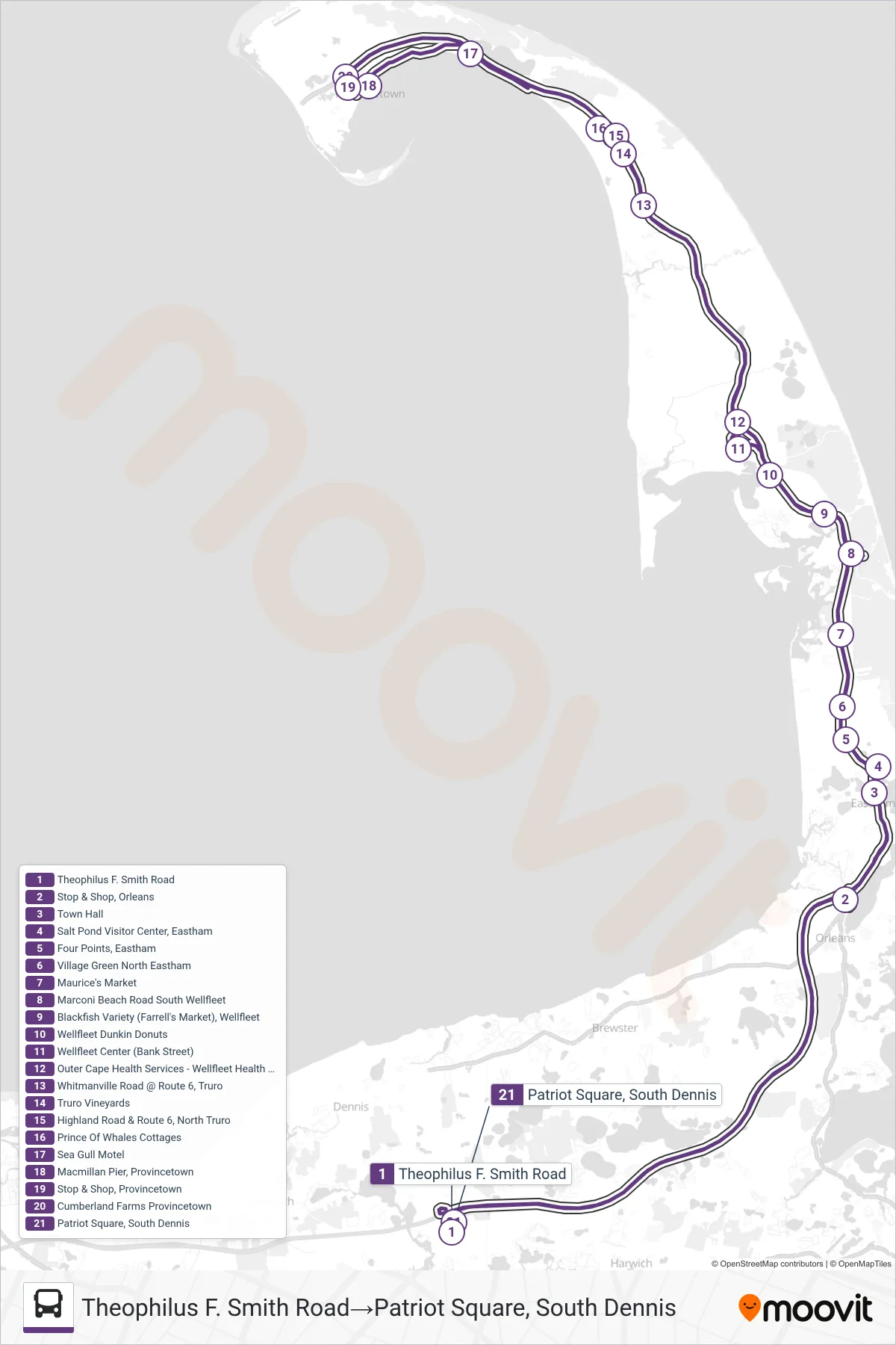
Stops list (FLEX - Theophilus F. Smith Road→Patriot Square, South Dennis)
- Theophilus F. Smith Road
- Stop & Shop, Orleans
- Town Hall
- Salt Pond Visitor Center, Eastham
- Four Points, Eastham
- Village Green North Eastham
- Maurice's Market
- Marconi Beach Road South Wellfleet
- Blackfish Variety (Farrell's Market), Wellfleet
- Wellfleet Dunkin Donuts
- Wellfleet Center (Bank Street)
- Outer Cape Health Services - Wellfleet Health Center
- Whitmanville Road @ Route 6, Truro
- Truro Vineyards
- Highland Road & Route 6, North Truro
- Prince Of Whales Cottages
- Sea Gull Motel
- Macmillan Pier, Provincetown
- Stop & Shop, Provincetown
- Cumberland Farms Provincetown
- Patriot Square, South Dennis
Change direction
- Route Map - FLEX - Theophilus F. Smith Road→Stop & Shop, Orleans
- Route Map - FLEX - Stop & Shop, Orleans→Patriot Square, South Dennis
- Route Map - FLEX - Cumberland Farms Provincetown→Star Market, Harwich Port
- Route Map - FLEX - Stop & Shop, Orleans→Cumberland Farms Provincetown
- Route Map - FLEX - Cumberland Farms Provincetown→Patriot Square, South Dennis
- Route Map - FLEX - Cumberland Farms Provincetown→Stop & Shop, Orleans
- Route Map - FLEX - Theophilus F. Smith Road→Cumberland Farms Provincetown
- Route Map - FLEX - Star Market, Harwich Port→Cumberland Farms Provincetown