
GI-44 Bus Route Map
View the GI-44 route map and see all GI-44 stops along the route. The map of GI-44 shows where the bus travels and the location of each stop, making it easy to understand the entire route at a glance.
Explore VGO Gießen routes on the map and see where VGO Gießen bus services operate. Use the GI-44 map to find bus stops and see how the GI-44 connects different areas along its trip.
All GI-44 stops on the map are displayed in route order, helping you follow the GI-44 bus from the first stop to the last.
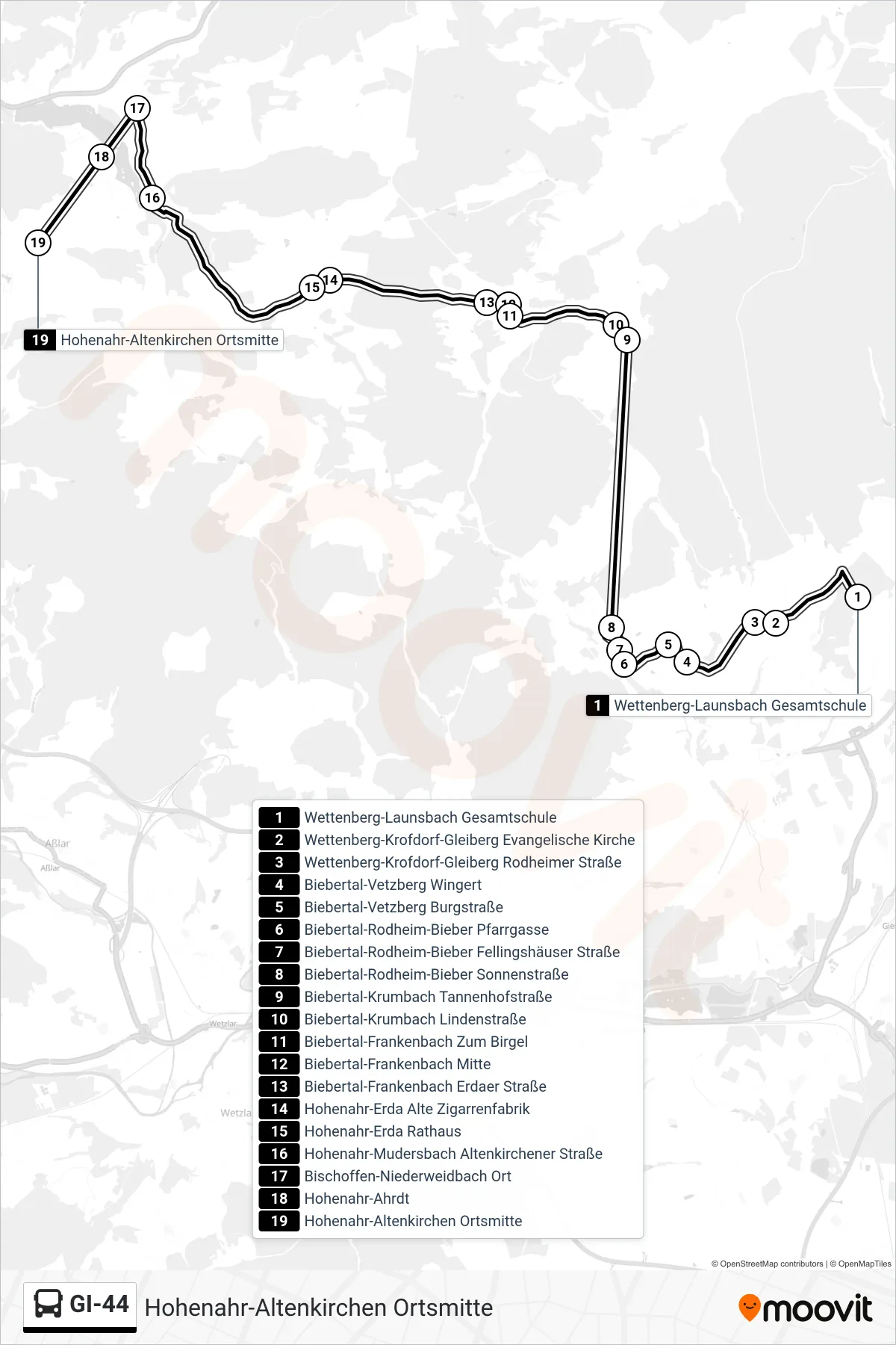
Stops list (GI-44 - Hohenahr-Altenkirchen Ortsmitte)
- Wettenberg-Launsbach Gesamtschule
- Wettenberg-Krofdorf-Gleiberg Evangelische Kirche
- Wettenberg-Krofdorf-Gleiberg Rodheimer Straße
- Biebertal-Vetzberg Wingert
- Biebertal-Vetzberg Burgstraße
- Biebertal-Rodheim-Bieber Pfarrgasse
- Biebertal-Rodheim-Bieber Fellingshäuser Straße
- Biebertal-Rodheim-Bieber Sonnenstraße
- Biebertal-Krumbach Tannenhofstraße
- Biebertal-Krumbach Lindenstraße
- Biebertal-Frankenbach Zum Birgel
- Biebertal-Frankenbach Mitte
- Biebertal-Frankenbach Erdaer Straße
- Hohenahr-Erda Alte Zigarrenfabrik
- Hohenahr-Erda Rathaus
- Hohenahr-Mudersbach Altenkirchener Straße
- Bischoffen-Niederweidbach Ort
- Hohenahr-Ahrdt
- Hohenahr-Altenkirchen Ortsmitte
Change direction
- Route Map - GI-44 - Wettenberg-Krofdorf-Gleiberg Kronzenborner Weg
- Route Map - GI-44 - Wettenberg-Krofdorf-Gleiberg Apotheke
- Route Map - GI-44 - Biebertal-Königsberg am Heddrich
- Route Map - GI-44 - Wettenberg-Launsbach Gesamtschule
- Route Map - GI-44 - Biebertal-Rodheim-Bieber Grundschule
- Route Map - GI-44 - Wettenberg-Launsbach Mittelmark
- Route Map - GI-44 - Wettenberg-Wißmar Auf Der Heide
- Route Map - GI-44 - Biebertal-Fellingshausen Friedhof
- Route Map - GI-44 - Hohenahr-Erda Rathaus
- Route Map - GI-44 - Biebertal-Frankenbach Erdaer Straße
- Route Map - GI-44 - Biebertal-Vetzberg Burgstraße