
I Bus Route Map
View the I route map and see all I stops along the route. The map of I shows where the bus travels and the location of each stop, making it easy to understand the entire route at a glance.
Explore ATMA S.c.p.a. routes on the map and see where ATMA S.c.p.a. bus services operate. Use the I map to find bus stops and see how the I connects different areas along its trip.
All I stops on the map are displayed in route order, helping you follow the I bus from the first stop to the last.
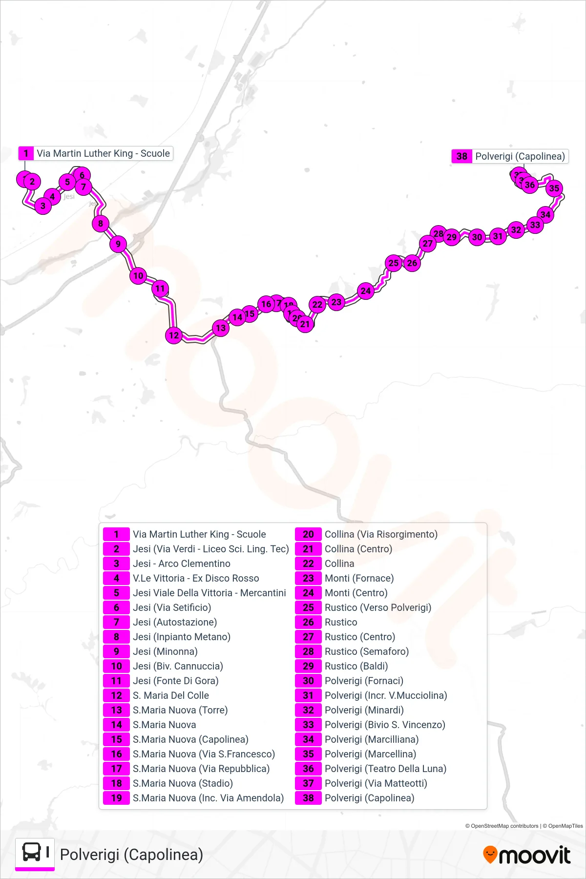
Stops list (I - Polverigi (Terminal))
- Martin Luther King Street - Schools
- Jesi (Via Verdi - Science Linguistic Technical School)
- Jesi - Clementine Arch
- Victory Avenue - Former Red Disco
- Jesi Victory Avenue - Mercantini
- Jesi (Silk Factory Road)
- Jesi (Bus Station)
- Jesi (Methane Plant)
- Jesi (Minonna)
- Jesi (Cannuccia Junction)
- Jesi (Fonte Di Gora)
- St. Maria Del Colle
- Santa Maria Nuova (Tower)
- Santa Maria Nuova
- Santa Maria Nuova (Terminal)
- Santa Maria Nuova (Via San Francesco)
- Santa Maria Nuova (Republic Street)
- Santa Maria Nuova (Stadium)
- Santa Maria Nuova (Amendola St. Junction)
- Collina (Risorgimento Street)
- Collina (Center)
- Collina
- Monti (Furnace)
- Monti (Center)
- Rustico (Towards Polverigi)
- Rustico
- Rustico (Center)
- Rustico (Traffic Light)
- Rustico (Baldi)
- Polverigi (Fornaci)
- Polverigi (Mucciolina Street Junction)
- Polverigi (Minardi)
- Polverigi (San Vincenzo Junction)
- Polverigi (Marcilliana)
- Polverigi (Marcellina)
- Polverigi (Teatro Della Luna)
- Polverigi (Matteotti Street)
- Polverigi (Terminal)
Change direction
- Route Map - I - Osimo (Terminal)
- Route Map - I - Martin Luther King Avenue - High School
- Route Map - I - Viale Del Lavoro - Gas Station
- Route Map - I - Agugliano (Cemetery)
- Route Map - I - Casine Paterno (Center)
- Route Map - I - Collina (Center)
- Route Map - I - Via Misa (Milk Center)
- Route Map - I - Rustico
- Route Map - I - Agugliano Via A. D. Gasperi
- Route Map - I - Polverigi (Cemetery)
- Route Map - I - Jesi (Bus Station)
- Route Map - I - Piazza Cavour (Conerobus North Lines)
- Route Map - I - Santa Maria Nuova (Terminal)
- Route Map - I - Chiaravalle Terminal
- Route Map - I - Polverigi (Terminal)
- Route Map - I - Agugliano (Cemetery)
- Route Map - I - Santa Maria Nuova (Terminal)