
N3S Bus Route Map
View the N3S route map and see all N3S stops along the route. The map of N3S shows where the bus travels and the location of each stop, making it easy to understand the entire route at a glance.
Explore ATAC routes on the map and see where ATAC bus services operate. Use the N3S map to find bus stops and see how the N3S connects different areas along its trip.
All N3S stops on the map are displayed in route order, helping you follow the N3S bus from the first stop to the last.
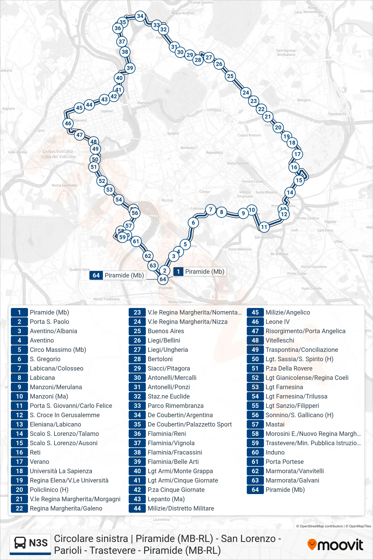
Stops list (N3S - Ostiense Square-Pyramid (Metro-Rail))
- Pyramid (Metro)
- St. Paul's Gate
- Aventino/Albania
- Aventino
- Circus Maximus (Metro)
- St. Gregory
- Labicana/Colosseum
- Labicana
- Manzoni/Merulana
- Manzoni
- Porta San Giovanni/Carlo Felice
- Holy Cross in Jerusalem
- Eleniana/Labicano
- San Lorenzo Station/Talamo
- San Lorenzo Station/Ausoni
- Reti
- Verano
- Sapienza University
- Regina Elena/University Avenue
- Policlinico Hospital
- Queen Margherita Ave/Morgagni
- Regina Margherita/Galeno
- Regina Margherita Ave/Nomentana
- Queen Margherita Avenue/Nice
- Buenos Aires
- Liegi/Bellini
- Liegi/Hungary
- Bertoloni
- Siacci/Pitagora
- Antonelli/Mercalli
- Antonelli/Ponzi
- Euclide Station
- Remembrance Park
- De Coubertin/Argentina
- De Coubertin/Sports Palace
- Flaminia/Reni
- Flaminia/Vignola
- Flaminia/Fracassini
- Flaminia/Fine Arts
- Army Waterfront/Monte Grappa
- Armi Waterfront/Five Days
- Piazza Five Days
- Lepanto (Metro A)
- Milizie/Military District
- Milizie/Angelico
- Leone IV
- Risorgimento/Porta Angelica
- Vitelleschi
- Traspontina/Conciliazione
- Lungotevere Sassia/Santo Spirito (H)
- Piazza Della Rovere
- Lungotevere Gianicolense/Regina Coeli
- Farnesina Waterfront
- Lungotevere Farnesina/Trilussa
- Sanzio Waterfront/Filipperi
- Sonnino/San Gallicano (Hospital)
- Mastai
- Morosini E./New Regina Margherita (Hospital)
- Trastevere/Ministry of Public Education
- Induno
- Porta Portese
- Marmorata/Vanvitelli
- Marmorata/Galvani
- Pyramid (Metro)