
P14 Bus Route Map
View the P14 route map and see all P14 stops along the route. The map of P14 shows where the bus travels and the location of each stop, making it easy to understand the entire route at a glance.
Explore Adriabus S.p.A. routes on the map and see where Adriabus S.p.A. bus services operate. Use the P14 map to find bus stops and see how the P14 connects different areas along its trip.
All P14 stops on the map are displayed in route order, helping you follow the P14 bus from the first stop to the last.
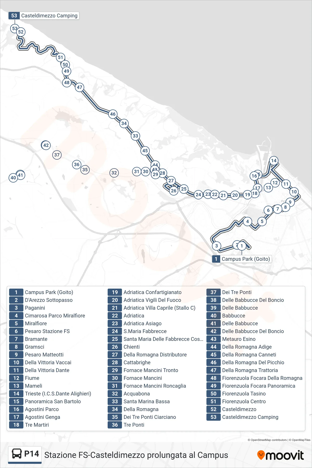
Stops list (P14 - Casteldimezzo Camping)
- Campus Park (Goito)
- D'Arezzo Underpass
- Paganini
- Cimarosa Miralfiore Park
- Miralfiore
- Pesaro Railway Station
- Bramante
- Gramsci
- Pesaro Matteotti
- Vittoria Vaccai
- Vittoria Dante Street
- River
- Mameli
- Trieste (ICS Dante Alighieri)
- San Bartolo Panoramic Road
- Agostini Park
- Agostini Genga
- Tre Martiri
- Adriatic Confartigianato
- Adriatica Fire Station
- Adriatica Villa Caprile (Bay C)
- Adriatica
- Adriatica Asiago
- Santa Maria Fabbrecce
- Santa Maria Delle Fabbrecce Costa Del Ciacco
- Chienti
- Della Romagna Gas Station
- Cattabrighe
- Mancini Tronto Furnace
- Fornace Mancini
- Fornace Mancini Roncaglia
- Acquabona
- Santa Marina Lower
- Della Romagna
- Tre Ponti Ciarciano
- Three Bridges
- Three Bridges
- Babbucce Del Boncio
- Delle Babbucce
- Babbucce
- Delle Babbucce
- Babbucce Del Boncio
- Metauro Esino
- Della Romagna Adige
- Romagna Canneti
- Della Romagna Del Picchio
- Romagna Trattoria
- Fiorenzuola Focara Della Romagna
- Fiorenzuola Focara Panoramic
- Fiorenzuola Tasino
- Fiorenzuola Center
- Casteldimezzo
- Casteldimezzo Camping