
R16 Bus Route Map
View the R16 route map and see all R16 stops along the route. The map of R16 shows where the bus travels and the location of each stop, making it easy to understand the entire route at a glance.
Explore Verkehrsbetriebe Westfalen-Süd routes on the map and see where Verkehrsbetriebe Westfalen-Süd bus services operate. Use the R16 map to find bus stops and see how the R16 connects different areas along its trip.
All R16 stops on the map are displayed in route order, helping you follow the R16 bus from the first stop to the last.
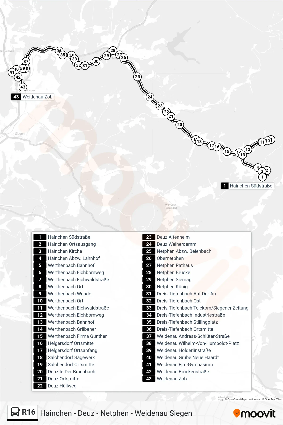
Stops list (R16 - Weidenau Zob Bstg 2)
- Hainchen Südstraße
- Hainchen Ortsausgang
- Hainchen Kirche
- Hainchen Abzw. Lahnhof
- Werthenbach Bahnhof
- Werthenbach Eichbornweg
- Werthenbach Eichwaldstraße
- Werthenbach Ort
- Werthenbach Wende
- Werthenbach Ort
- Werthenbach Eichwaldstraße
- Werthenbach Eichbornweg
- Werthenbach Bahnhof
- Werthenbach Gräbener
- Werthenbach Firma Günther
- Helgersdorf Ortsmitte
- Helgersdorf Ortsanfang
- Salchendorf Sägewerk
- Salchendorf Ortsmitte
- Deuz In Der Brachbach
- Deuz Ortsmitte
- Deuz Hüllweg
- Deuz Altenheim
- Deuz Weiherdamm
- Netphen Abzw. Beienbach
- Obernetphen
- Netphen Rathaus
- Netphen Brücke
- Netphen Siemag
- Netphen König
- Dreis-Tiefenbach Auf Der Au
- Dreis-Tiefenbach Ost
- Dreis-Tiefenbach Telekom/Siegener Zeitung
- Dreis-Tiefenbach Industriestraße
- Dreis-Tiefenbach Stillingplatz
- Dreis-Tiefenbach Ortsmitte
- Weidenau Andreas-Schlüter-Straße
- Weidenau Wilhelm-Von-Humboldt-Platz
- Weidenau Hölderlinstraße
- Weidenau Grube Neue Haardt
- Weidenau Fjm-Gymnasium
- Weidenau Brückenstraße
- Weidenau Zob