
R32 Bus Route Map
View the R32 route map and see all R32 stops along the route. The map of R32 shows where the bus travels and the location of each stop, making it easy to understand the entire route at a glance.
Explore Verkehrsbetriebe Westfalen-Süd routes on the map and see where Verkehrsbetriebe Westfalen-Süd bus services operate. Use the R32 map to find bus stops and see how the R32 connects different areas along its trip.
All R32 stops on the map are displayed in route order, helping you follow the R32 bus from the first stop to the last.
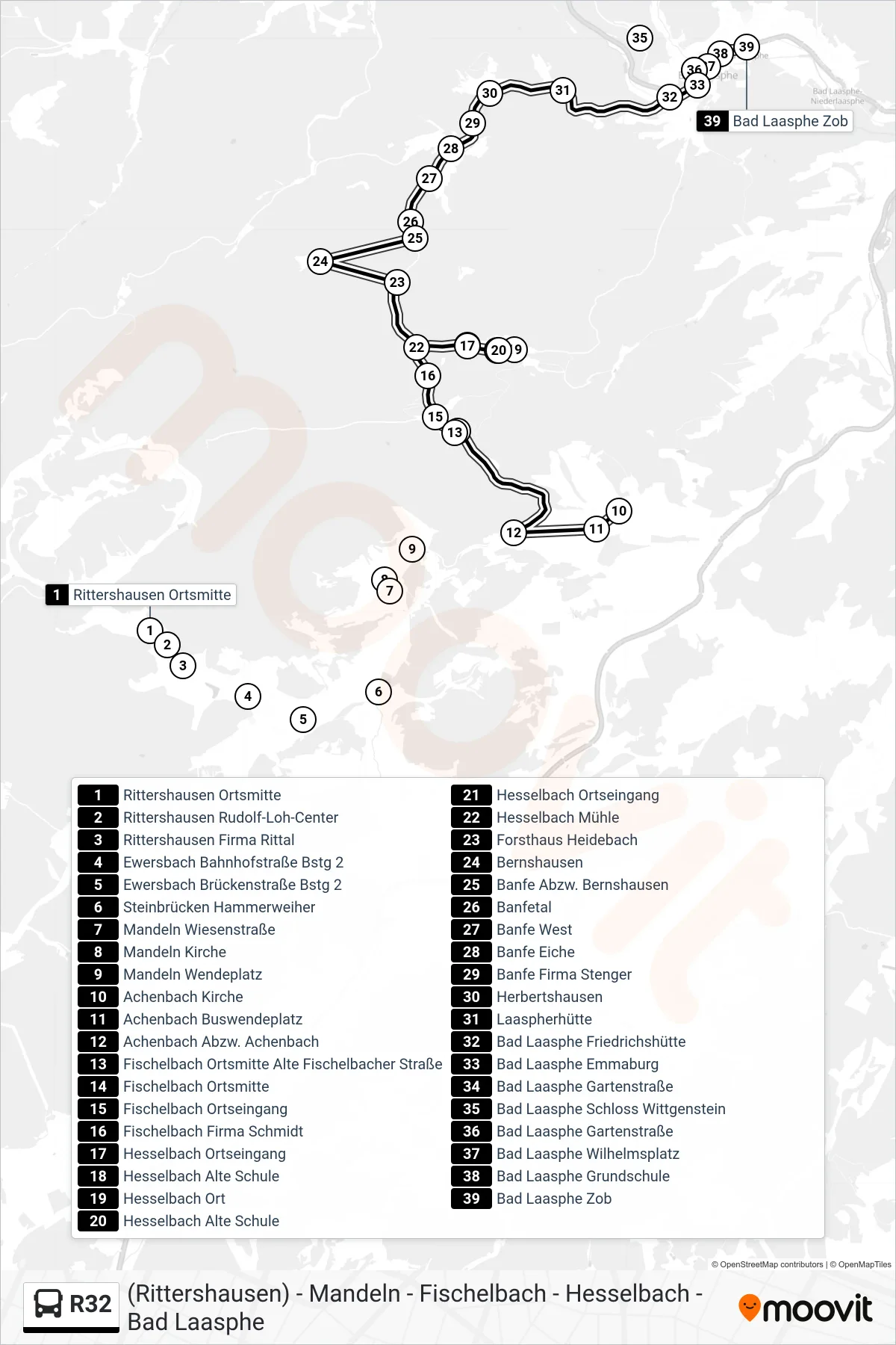
Stops list (R32 - Bad Laasphe Zob Bstg 5)
- Rittershausen Ortsmitte
- Rittershausen Rudolf-Loh-Center
- Rittershausen Firma Rittal
- Ewersbach Bahnhofstraße Bstg 2
- Ewersbach Brückenstraße Bstg 2
- Steinbrücken Hammerweiher
- Mandeln Wiesenstraße
- Mandeln Kirche
- Mandeln Wendeplatz
- Achenbach Kirche
- Achenbach Buswendeplatz
- Achenbach Abzw. Achenbach
- Fischelbach Ortsmitte Alte Fischelbacher Straße
- Fischelbach Ortsmitte
- Fischelbach Ortseingang
- Fischelbach Firma Schmidt
- Hesselbach Ortseingang
- Hesselbach Alte Schule
- Hesselbach Ort
- Hesselbach Alte Schule
- Hesselbach Ortseingang
- Hesselbach Mühle
- Forsthaus Heidebach
- Bernshausen
- Banfe Abzw. Bernshausen
- Banfetal
- Banfe West
- Banfe Eiche
- Banfe Firma Stenger
- Herbertshausen
- Laaspherhütte
- Bad Laasphe Friedrichshütte
- Bad Laasphe Emmaburg
- Bad Laasphe Gartenstraße
- Bad Laasphe Schloss Wittgenstein
- Bad Laasphe Gartenstraße
- Bad Laasphe Wilhelmsplatz
- Bad Laasphe Grundschule
- Bad Laasphe Zob
Change direction
- Route Map - R32 - Fischelbach Ortsmitte Alte Fischelbacher Straße
- Route Map - R32 - Hesselbach Ort
- Route Map - R32 - Fischelbach Ortsmitte
- Route Map - R32 - Herbertshausen
- Route Map - R32 - Rittershausen Ortsmitte
- Route Map - R32 - Fischelbach Ortsmitte Alte Fischelbacher Straße
- Route Map - R32 - Bad Laasphe Friedrichshütte
- Route Map - R32 - Mandeln Wendeplatz
- Route Map - R32 - Fischelbach Ortsmitte
- Route Map - R32 - Bad Laasphe Schloss Wittgenstein
- Route Map - R32 - Banfe Grundschule
- Route Map - R32 - Bernshausen
- Route Map - R32 - Mandeln Wendeplatz
- Route Map - R32 - Banfe Grundschule
- Route Map - R32 - Sohl