
S81 Light Rail Route Map
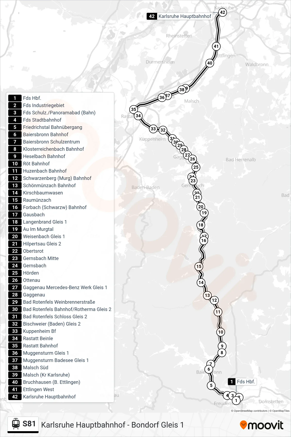
View the S81 route map and see all S81 stops along the route. The map of S81 shows where the light rail travels and the location of each stop, making it easy to understand the entire route at a glance.
Explore Albtal-Verkehrs-Gesellschaft mbH routes on the map and see where Albtal-Verkehrs-Gesellschaft mbH light rail services operate. Use the S81 map to find light rail stations and see how the S81 connects different areas along its trip.
All S81 stops on the map are displayed in route order, helping you follow the S81 light rail from the first station to the last.
Stops list (S81 - Karlsruhe Hauptbahnhof)
- Fds Hbf.
- Fds Industriegebiet
- Fds Schulz./Panoramabad (Bahn)
- Fds Stadtbahnhof
- Friedrichstal Bahnübergang
- Baiersbronn Bahnhof
- Baiersbronn Schulzentrum
- Klosterreichenbach Bahnhof
- Heselbach Bahnhof
- Röt Bahnhof
- Huzenbach Bahnhof
- Schwarzenberg (Murg) Bahnhof
- Schönmünzach Bahnhof
- Kirschbaumwasen
- Raumünzach
- Forbach (Schwarzw) Bahnhof
- Gausbach
- Langenbrand Gleis 1
- Au Im Murgtal
- Weisenbach Gleis 1
- Hilpertsau Gleis 2
- Obertsrot
- Gernsbach Mitte
- Gernsbach
- Hörden
- Ottenau
- Gaggenau Mercedes-Benz Werk Gleis 1
- Gaggenau
- Bad Rotenfels Weinbrennerstraße
- Bad Rotenfels Bahnhof/Rotherma Gleis 2
- Bad Rotenfels Schloss Gleis 2
- Bischweier (Baden) Gleis 2
- Kuppenheim Bf
- Rastatt Beinle
- Rastatt Bahnhof
- Muggensturm Gleis 1
- Muggensturm Badesee Gleis 1
- Malsch Süd
- Malsch (Kr Karlsruhe)
- Bruchhausen (B. Ettlingen)
- Ettlingen West
- Karlsruhe Hauptbahnhof