
SB54 Bus Route Map
View the SB54 route map and see all SB54 stops along the route. The map of SB54 shows where the bus travels and the location of each stop, making it easy to understand the entire route at a glance.
Explore RSVG Rhein-Sieg-Verkehrsgesellschaft mbH routes on the map and see where RSVG Rhein-Sieg-Verkehrsgesellschaft mbH bus services operate. Use the SB54 map to find bus stops and see how the SB54 connects different areas along its trip.
All SB54 stops on the map are displayed in route order, helping you follow the SB54 bus from the first stop to the last.
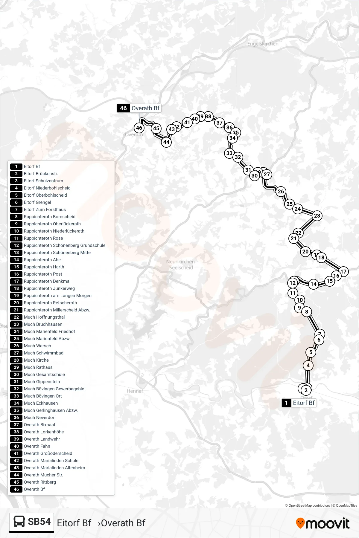
Stops list (SB54 - Eitorf Bf→Overath Bf)
- Eitorf Bf
- Eitorf Brückenstr.
- Eitorf Schulzentrum
- Eitorf Niederbohlscheid
- Eitorf Oberbohlscheid
- Eitorf Grengel
- Eitorf Zum Forsthaus
- Ruppichteroth Bornscheid
- Ruppichteroth Oberlückerath
- Ruppichteroth Niederlückerath
- Ruppichteroth Rose
- Ruppichteroth Schönenberg Grundschule
- Ruppichteroth Schönenberg Mitte
- Ruppichteroth Ahe
- Ruppichteroth Harth
- Ruppichteroth Post
- Ruppichteroth Denkmal
- Ruppichteroth Junkerweg
- Ruppichteroth am Langen Morgen
- Ruppichteroth Retscheroth
- Ruppichteroth Millerscheid Abzw.
- Much Hoffnungsthal
- Much Bruchhausen
- Much Marienfeld Friedhof
- Much Marienfeld Abzw.
- Much Wersch
- Much Schwimmbad
- Much Kirche
- Much Rathaus
- Much Gesamtschule
- Much Gippenstein
- Much Bövingen Gewerbegebiet
- Much Bövingen Ort
- Much Eckhausen
- Much Gerlinghausen Abzw.
- Much Neverdorf
- Overath Bixnaaf
- Overath Lorkenhöhe
- Overath Landwehr
- Overath Fahn
- Overath Großoderscheid
- Overath Marialinden Schule
- Overath Marialinden Altenheim
- Overath Mucher Str.
- Overath Rittberg
- Overath Bf
Change direction
- Route Map - SB54 - Eitorf Bf→Much Gesamtschule
- Route Map - SB54 - Much Gesamtschule→Overath Mucher Str.
- Route Map - SB54 - Ruppichteroth Post→Much Gesamtschule
- Route Map - SB54 - Much Gesamtschule→Ruppichteroth Post
- Route Map - SB54 - Overath Bf→Eitorf Bf
- Route Map - SB54 - Ruppichteroth Post→Overath Bf
- Route Map - SB54 - Much Gesamtschule→Eitorf Bf
- Route Map - SB54 - Much Gesamtschule→Overath Bf
- Route Map - SB54 - Overath Bf→Much Gesamtschule
- Route Map - SB54 - Overath Mucher Str.→Much Gesamtschule