
U41 Subway Route Map
View the U41 route map and see all U41 stops along the route. The map of U41 shows where the subway travels and the location of each stop, making it easy to understand the entire route at a glance.
Explore DSW U-Bahn routes on the map and see where DSW U-Bahn subway services operate. Use the U41 map to find subway stations and see how the U41 connects different areas along its trip.
All U41 stops on the map are displayed in route order, helping you follow the U41 subway from the first station to the last.
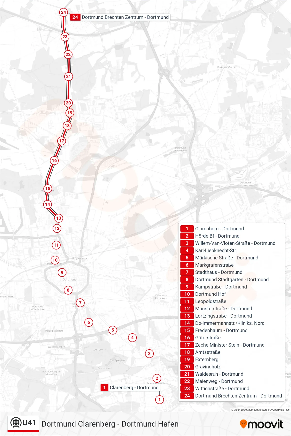
Stops list (U41 - Dortmund Brechten Zentrum)
- Clarenberg - Dortmund
- Hörde Bf - Dortmund
- Willem-Van-Vloten-Straße - Dortmund
- Karl-Liebknecht-Str.
- Märkische Straße - Dortmund
- Markgrafenstraße
- Stadthaus - Dortmund
- Dortmund Stadtgarten - Dortmund
- Kampstraße - Dortmund
- Dortmund Hbf
- Leopoldstraße
- Münsterstraße - Dortmund
- Lortzingstraße - Dortmund
- Do-Immermannstr./Klinikz. Nord
- Fredenbaum - Dortmund
- Güterstraße
- Zeche Minister Stein - Dortmund
- Amtsstraße
- Externberg
- Grävingholz
- Waldesruh - Dortmund
- Maienweg - Dortmund
- Wittichstraße - Dortmund
- Dortmund Brechten Zentrum - Dortmund
Change direction
- Route Map - U41 - Dortmund Hbf
- Route Map - U41 - Dortmund Stadion
- Route Map - U41 - Dortmund Oetringhauser Straße
- Route Map - U41 - Dortmund Lortzingstraße
- Route Map - U41 - Dortmund Fredenbaum
- Route Map - U41 - Dortmund Lortzingstraße
- Route Map - U41 - Lünen Brambauer Verkehrshof
- Route Map - U41 - Dortmund Markgrafenstraße
- Route Map - U41 - Dortmund Hafen
- Route Map - U41 - Dortmund Stadtgarten
- Route Map - U41 - Dortmund Stadthaus
- Route Map - U41 - Dortmund Hbf
- Route Map - U41 - Dortmund Clarenberg
- Route Map - U41 - Dortmund Westfalenhallen
- Route Map - U41 - Dortmund Grävingholz
- Route Map - U41 - Dortmund Stadtgarten