
V Bus Route Map
View the V route map and see all V stops along the route. The map of V shows where the bus travels and the location of each stop, making it easy to understand the entire route at a glance.
Explore Aachener Straßenbahn- und Energieversorgungs-AG routes on the map and see where Aachener Straßenbahn- und Energieversorgungs-AG bus services operate. Use the V map to find bus stops and see how the V connects different areas along its trip.
All V stops on the map are displayed in route order, helping you follow the V bus from the first stop to the last.
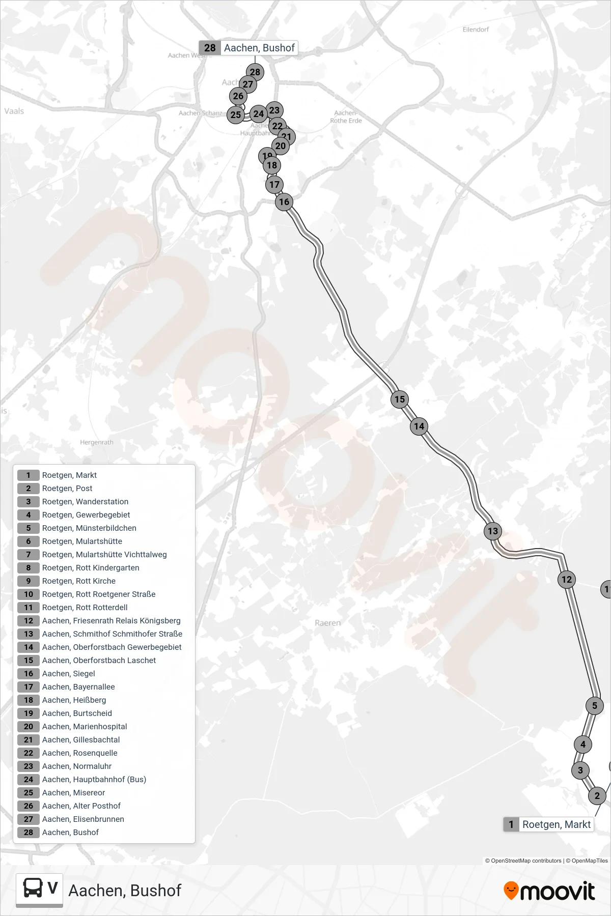
Stops list (V - Aachen, Bushof)
- Roetgen, Post
- Roetgen, Wanderstation
- Roetgen, Gewerbegebiet
- Roetgen, Münsterbildchen
- Roetgen, Mulartshütte
- Roetgen, Mulartshütte Vichttalweg
- Roetgen, Rott Kindergarten
- Roetgen, Rott Kirche
- Roetgen, Rott Roetgener Straße
- Roetgen, Rott Rotterdell
- Aachen, Friesenrath Relais Königsberg
- Aachen, Schmithof Schmithofer Straße
- Aachen, Oberforstbach Gewerbegebiet
- Aachen, Oberforstbach Laschet
- Aachen, Siegel
- Aachen, Bayernallee
- Aachen, Heißberg
- Aachen, Burtscheid
- Aachen, Marienhospital
- Aachen, Gillesbachtal
- Aachen, Rosenquelle
- Aachen, Normaluhr
- Aachen, Hauptbahnhof (Bus)
- Aachen, Misereor
- Aachen, Alter Posthof
- Aachen, Elisenbrunnen
- Aachen, Bushof
Change direction
- Route Map - V - Monschau, Gymnasium
- Route Map - V - Eilendorf Schubertstraße
- Route Map - V - Vossenack Gymnasium
- Route Map - V - Würselen Markt
- Route Map - V - Atsch Im Rehgrund
- Route Map - V - Aachen, Brüsseler Ring
- Route Map - V - Lichtenbusch
- Route Map - V - Aldenhoven Markt
- Route Map - V - Brand Schulzentrum
- Route Map - V - Lammersdorf Kirche
- Route Map - V - Rothe Kreuz
- Route Map - V - Monschau Gymnasium
- Route Map - V - Alsdorf, Hoengen Marienstraße
- Route Map - V - Liester Schulzentrum
- Route Map - V - Werth Kreuzung
- Route Map - V - Hücheln Wasserfeld
- Route Map - V - Würselen, Parkhotel
- Route Map - V - Aachen, Siegel
- Route Map - V - Eschweiler Bushof
- Route Map - V - Sief Schule
- Route Map - V - Kohlscheid Markt
- Route Map - V - Kinzweiler
- Route Map - V - Bank - Vetschau - Laurensberg Schulzentrum
- Route Map - V - Hamich
- Route Map - V - Langerwehe, Heistern Fourné
- Route Map - V - Breinigerberg
- Route Map - V - Kellersberg
- Route Map - V - Heistern Fourné
- Route Map - V - Barbarakirche
- Route Map - V - Aachen, Eilendorf Karlstraße
- Route Map - V - Stolberg Hans-Böckler-Straße
- Route Map - V - Alsdorf Annapark
- Route Map - V - Ronheider Weg (Pius-Gymnasium)
- Route Map - V - Hücheln
- Route Map - V - Merkstein Gesamtschule
- Route Map - V - Eschweiler Bushof
- Route Map - V - Verlautenheide Endstraße
- Route Map - V - Herzogenrath, Kohlscheid Altes Rathaus
- Route Map - V - Fringsgraben
- Route Map - V - Monschau, Altstadt
- Route Map - V - Schmithofer Straße
- Route Map - V - Aachen, Eilendorf Schubertstraße
- Route Map - V - Neusen Kreuz
- Route Map - V - Aachen, Ronheider Weg
- Route Map - V - Simmerath Bushof
- Route Map - V - Stolberg Mühlener Bahnhof
- Route Map - V - Mausbach Kirche
- Route Map - V - Lammersdorf Grundschule
- Route Map - V - Volkenrath
- Route Map - V - Rott - Roetgen Post
- Route Map - V - Rollesbroich Schlad
- Route Map - V - Münsterbusch Kreuz
- Route Map - V - Alsdorf am Klött
- Route Map - V - Eschweiler, St. Jöris Schule
- Route Map - V - Aachen, Prager Ring
- Route Map - V - Würselen Broich Gymnasium
- Route Map - V - Hüls Schulzentrum
- Route Map - V - Heistern-Schevenhütte
- Route Map - V - Stolberg Birkengang
- Route Map - V - Roetgen Post
- Route Map - V - Hoengen Markt
- Route Map - V - Würselen, Markt
- Route Map - V - Buschmühle Friedhof
- Route Map - V - Würselen, Bardenberg Pley
- Route Map - V - Aachen, Kornelimünster Napoleonsberg (Eifelsteig)
- Route Map - V - Merkstein Gesamtschule
- Route Map - V - Eschweiler Südstraße
- Route Map - V - Vossenack Gymnasium
- Route Map - V - Donnerberg - Atsch Im Rehgrund
- Route Map - V - Schleiden Busbahnhof
- Route Map - V - Langerwehe Schulzentrum
- Route Map - V - Kaiserplatz
- Route Map - V - Hücheln Wasserfeld
- Route Map - V - Zweifall Kirche
- Route Map - V - Eschweiler Waldschule
- Route Map - V - Brand
- Route Map - V - Hält Nur Zum Aussteigen
- Route Map - V - Gressenich Kapelle
- Route Map - V - Hauptbahnhof - Schanz - Uniklinik
- Route Map - V - Stolberg, Liester Schulzentrum
- Route Map - V - Zweifall Solchbachtal
- Route Map - V - Hoengen Kirche
- Route Map - V - Schmithof Schule
- Route Map - V - Gressenich Poststraße
- Route Map - V - Aachen Bushof
- Route Map - V - Laurensberg
- Route Map - V - Mariadorf Dreieck
- Route Map - V - Aachen, Hüls
- Route Map - V - Alsdorf, Busch Bahnhof (Bus)
- Route Map - V - Verlautenheide Quinx
- Route Map - V - Berensberg
- Route Map - V - Hürtgenwald, Vossenack Gymnasium
- Route Map - V - Locht Zollmuseum
- Route Map - V - Breinig Entengasse
- Route Map - V - Mausbach Kirche
- Route Map - V - Sief - Oberforstbach
- Route Map - V - Alsdorf Kubiz
- Route Map - V - Aachen, Laurensberg Schulzentrum (Parkplatz)
- Route Map - V - Werth Kreuzung
- Route Map - V - Würselen, Rathaus
- Route Map - V - Eilendorf Karlstraße
- Route Map - V - Aachen Bushof
- Route Map - V - Simmerath, Bushof
- Route Map - V - Stolberg, Mausbach Kirche
- Route Map - V - Schleckheim (Weiter Als Li. 65)
- Route Map - V - Simmerath, Strauch Gartenstraße
- Route Map - V - Eschweiler, Volkenrath
- Route Map - V - Eschweiler Oberdorf
- Route Map - V - Laurensberg Schulzentrum
- Route Map - V - Schmidt (Gerstenhof)
- Route Map - V - Herzogenrath, Kohlscheid Kämpchen
- Route Map - V - Erkensruhr Finkenauel
- Route Map - V - Schevenhütte Hotel Roeb
- Route Map - V - Walheim Hasbach
- Route Map - V - Herzogenrath, Kohlscheid Rumpen Im Grüntal
- Route Map - V - Euchen
- Route Map - V - Aachen Siegel
- Route Map - V - Merkstein Stadion
- Route Map - V - Werth Brunnenweg
- Route Map - V - Aachen, Brand Freund
- Route Map - V - Simmerath Sekundarschule
- Route Map - V - Würselen Parkhotel
- Route Map - V - Brand Ringstraße
- Route Map - V - Laurensberg Schulzentrum
- Route Map - V - Aachen, Uniklinik
- Route Map - V - Roetgen, Post
- Route Map - V - Würselen Parkhotel - Aachen Bushof
- Route Map - V - Gressenich Kapelle
- Route Map - V - Kaninsberg
- Route Map - V - Ronheider Weg
- Route Map - V - Alsdorf Annapark
- Route Map - V - Eilendorf Josefstraße
- Route Map - V - Baesweiler, Loverich Puffendorfer Straße
- Route Map - V - Herzogenrath Bahnhof (Weiter Als Li. 54)
- Route Map - V - Neu-Lohn Wiesenstraße
- Route Map - V - Aachen, Preusweg
- Route Map - V - Aachen Rödgerbach
- Route Map - V - Uniklinik - Vaals Grenze
- Route Map - V - Herzogenrath Bahnhof
- Route Map - V - Augustastraße - Ronheider Weg
- Route Map - V - Elisenbrunnen
- Route Map - V - Würselen Parkhotel
- Route Map - V - Sief Schule (Magelspfad)
- Route Map - V - Horbach
- Route Map - V - Stolberg, Abzw. Venwegen
- Route Map - V - Süsterau
- Route Map - V - Kohlscheid Alte Post