Aldershot Go Station stop - Saturday schedule
| Line | Direction | Time |
|---|---|---|
| 4 | Appleby Go Station | 8:32 AM |
| 4 | Appleby Go Station | 9:32 AM |
| 4 | Aldershot Go Station | 10:29 AM |
| 4 | Appleby Go Station | 10:32 AM |
| 4 | Aldershot Go Station | 11:29 AM |
| 4 | Appleby Go Station | 11:32 AM |
| 4 | Aldershot Go Station | 12:29 PM |
| 4 | Appleby Go Station | 12:32 PM |
| 4 | Aldershot Go Station | 1:29 PM |
| 4 | Appleby Go Station | 1:32 PM |
| 4 | Aldershot Go Station | 2:29 PM |
| 4 | Appleby Go Station | 2:32 PM |
| 4 | Aldershot Go Station | 3:29 PM |
| 4 | Appleby Go Station | 3:32 PM |
| 4 | Aldershot Go Station | 4:29 PM |
| 4 | Appleby Go Station | 4:32 PM |
| 4 | Aldershot Go Station | 5:29 PM |
| 4 | Appleby Go Station | 5:32 PM |
| 4 | Aldershot Go Station | 6:29 PM |
| 4 | Appleby Go Station | 6:32 PM |
| 4 | Aldershot Go Station | 7:29 PM |
| 4 | John Street Terminal | 7:32 PM |
| 4 | Aldershot Go Station | 8:29 PM |
| 4 | John Street Terminal | 8:32 PM |
Directions to Aldershot Go Station (Burlington) with public transportation
The following transit lines have routes that pass near Aldershot Go Station
How to get to Aldershot Go Station by bus?
Click on the bus route to see step by step directions with maps, line arrival times and updated time schedules.
How to get to Aldershot Go Station by train?
Click on the train route to see step by step directions with maps, line arrival times and updated time schedules.
Bus stops near Aldershot Go Station in Burlington
- Aldershot Go Via Station Platform 10, 1 min walk,
- Aldershot Go, 2 min walk,
- Waterdown Rd. @ Masonry Crt., 10 min walk,
- Plains at St. Matthew's, 16 min walk,
- 201 North Service, 19 min walk,
Train stations near Aldershot Go Station in Burlington
- Aldershot, 4 min walk,
Bus lines to Aldershot Go Station in Burlington
- 18, Waterdown Walmart,
- LW, # | West Harbour Go,
- 11, 11 - Aldershot Go,
- 15, 15 - Aldershot Go,
- 17, 17 - U Of Waterloo,
- 18, 18f - Hamilton Go,
- 4, Appleby Go Station,
- 1, Appleby Go Station,
- 87, Aldershot Go Station,
What are the closest stations to Aldershot Go Station?
The closest stations to Aldershot Go Station are:
- Aldershot Go Via Station Platform 10 is 13 meters away, 1 min walk.
- Aldershot Go is 89 meters away, 2 min walk.
- Aldershot is 158 meters away, 4 min walk.
- Waterdown Rd. @ Masonry Crt. is 742 meters away, 10 min walk.
- Plains at St. Matthew's is 1063 meters away, 16 min walk.
- 201 North Service is 1414 meters away, 19 min walk.
Which bus lines stop near Aldershot Go Station?
These bus lines stop near Aldershot Go Station: 15, 17, 18, 4, 87.
Which train line stops near Aldershot Go Station?
LW
What’s the nearest train station to Aldershot Go Station in Burlington?
The nearest train station to Aldershot Go Station in Burlington is Aldershot. It’s a 4 min walk away.
What’s the nearest bus stop to Aldershot Go Station in Burlington?
The nearest bus stop to Aldershot Go Station in Burlington is Aldershot Go Via Station Platform 10. It’s a 1 min walk away.
What time is the first train to Aldershot Go Station in Burlington?
The LW is the first train that goes to Aldershot Go Station in Burlington. It stops nearby at 4:52 AM.
What time is the last train to Aldershot Go Station in Burlington?
The LW is the last train that goes to Aldershot Go Station in Burlington. It stops nearby at 1:27 AM.
What time is the first bus to Aldershot Go Station in Burlington?
The 18 is the first bus that goes to Aldershot Go Station in Burlington. It stops nearby at 3:51 AM.
What time is the last bus to Aldershot Go Station in Burlington?
The 18 is the last bus that goes to Aldershot Go Station in Burlington. It stops nearby at 3:53 AM.
How much is the train fare to Aldershot Go Station?
The train fare to Aldershot Go Station costs about $3.70 - $11.08.
How much is the bus fare to Aldershot Go Station?
The bus fare to Aldershot Go Station costs about $2.50 - $14.12.
See Aldershot Go Station, Burlington, on the map
Public transit to Aldershot Go Station stop (ID: 729) in Burlington
Looking for directions to Aldershot Go Station in Burlington, Canada?
Download the Moovit App to find the current schedule and step-by-step directions for Bus or Train routes that pass through Aldershot Go Station.
Looking for the nearest stops closest to Aldershot Go Station ? Check out this list of closest stops to your destination: Aldershot Go Via Station Platform 10; Aldershot Go; Aldershot; Waterdown Rd. @ Masonry Crt.; Plains at St. Matthew's; 201 North Service.
Bus: 15, 17, 18, 4, 87, LW, 11, 1.Train: LW, VIA RAIL, VIA RAIL, VIA RAIL.
We make riding on public transit to Aldershot Go Station easy, which is why over 1.5 million users, including users in Burlington trust Moovit as the best app for public transit.
Use the app to navigate to popular places including to the airport, hospital, stadium, grocery store, mall, coffee shop, school, college, and university.
Aldershot Go Station stop’s code is 729
The first line to this stop is 4, at 8:32 AM, and the last line is 4 at 8:32 PM.
This stop serves Burlington Transit’s lines
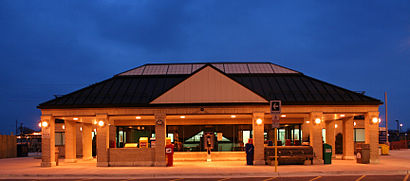
Aldershot GO Station is a railway station and bus station used by Via Rail and GO Transit, located at Highway 403 and Waterdown Road in the Aldershot community of Burlington, Ontario, Canada.Wiki
Bus stops near Aldershot Go Station
Aldershot Go Via Station Platform 10,Aldershot Go,Waterdown Rd. @ Masonry Crt.,Plains at St. Matthew's,201 North ServiceTrain station near Aldershot Go Station
AldershotPopular public transit stations in Burlington
Bronte Go,Wilson Ave at Keele St,Runnymede Station,County Court Blvd (S) E/Of Hurontario St,Derry Rd at Mississauga Rd,Pinebush Station,Eglinton Go,Grenoble Blvd N/Of Central Park Dr,Markham Go,Brock University,Drew Centre at Milton Go Station,Shaw St at Queen St West,Airport Rd At American Dr,Kipling Ave at Steeles Ave West,Sandalwood Pkwy E/Of Main St,Birchmount Rd at Kingston Rd North Side,Erin Centre Blvd West Of Erin Mills Pky,Brock Rd. @ Mclean Rd. (Aberfoyle) Park & Ride,First Ave. @ Front St. Park & Ride,Finch Ave S/Of Steeles AveGet around Toronto by public transit!
Traveling around Toronto has never been so easy. See step by step directions as you travel to any attraction, street or major public transit station. View bus and train schedules, arrival times, service alerts and detailed routes on a map, so you know exactly how to get to anywhere in Toronto.
When traveling to any destination around Toronto use Moovit's Live Directions with Get Off Notifications to know exactly where and how far to walk, how long to wait for your line, and how many stops are left. Moovit will alert you when it's time to get off — no need to constantly re-check whether yours is the next stop.
Wondering how to use public transit in Toronto or how to pay for public transit in Toronto? Moovit public transit app can help you navigate your way with public transit easily, and at minimum cost. It includes public transit fees, ticket prices, and costs. Looking for a map of Toronto public transit lines? Moovit public transit app shows all public transit maps in Toronto with all Bus, Train, Subway, Streetcar and Ferry routes and stops on an interactive map.
Toronto has 5 transit type(s), including: Bus, Train, Subway, Streetcar and Ferry, operated by several transit agencies, including TTC, TTC Streetcar, Toronto Subway, Brampton Transit, MiWay, York Region Transit, GO Transit Bus, GO Transit, Durham Region Transit, UP Express, Grand River Transit, Guelph Transit, grt, Hamilton Street Railway, Burlington Transit