Directions to St James Mill (Norwich) with public transport
The following transport lines have routes that pass near St James Mill
How to get to St James Mill by bus?
Click on the bus route to see step by step directions with maps, line arrival times and updated time schedules.
How to get to St James Mill by train?
Click on the train route to see step by step directions with maps, line arrival times and updated time schedules.
Bus stops near St James Mill in Norwich
- Palace Street, Norwich, 4 min walk,
- Anglia Square, Norwich, 6 min walk,
- Tombland, Norwich, 8 min walk,
- Prince Of Wales Road, Norwich, 11 min walk,
- Norwich, 18 min walk,
Bus lines to St James Mill in Norwich
- 32, Norwich City Centre,
- 10, Mousehold Heath - Eaton Park,
- 10A, Mousehold Heath - Cringleford,
- 11, Sprowston - Norfolk & Norwich Hospital,
- 11A, Sprowston - Norfolk & Norwich Hospital,
- 11B, Sprowston - Linacre Avenue - Tesco - Norwich City Centre,
- 11C, Heartsease - Norwich,
- 12, Wroxham - Norfolk & Norwich Hospital,
- 13, Spixworth - Attleborough,
- 21, N&N Hospital - Old Catton,
- 21A, N&N Hospital - Old Catton,
- 23, Horningtoft - North Elmham - Norwich,
- 24, Fakenham - Reepham - Norwich,
- 28, Norwich - Thorpe Marriott,
- 29, Norwich - Taverham,
- X29, Norwich - Fakenham,
- 35, Helledon - Norwich Airport - Norwich,
- 36, Horsford - Norwich,
- 36A, Horsford - Harleston,
- 36B, Horsford - Harleston,
What are the nearest stations to St James Mill?
The nearest stations to St James Mill are:
- Palace Street, Norwich is 250 meters away, 4 min walk.
- Anglia Square, Norwich is 444 meters away, 6 min walk.
- Tombland, Norwich is 537 meters away, 8 min walk.
- Prince Of Wales Road, Norwich is 813 meters away, 11 min walk.
- Norwich is 1362 meters away, 18 min walk.
Which bus lines stop near St James Mill?
These bus lines stop near St James Mill: 11A|PINK LINE, 15A|GREEN LINE, 501|PARK & RIDE, 55.
Which train line stops near St James Mill?
GREATER ANGLIA
What’s the nearest bus stop to St James Mill in Norwich?
The nearest bus stop to St James Mill in Norwich is Palace Street, Norwich. It’s a 4 min walk away.
See St James Mill, Norwich, on the map
Public Transit to St James Mill in Norwich
Wondering how to get to St James Mill in Norwich, United Kingdom? Moovit helps you find the best way to get to St James Mill with step-by-step directions from the nearest public transit station.
Moovit provides free maps and live directions to help you navigate through your city. View schedules, routes, timetables, and find out how long does it take to get to St James Mill in real time.
Looking for the nearest stop or station to St James Mill? Check out this list of stops closest to your destination: Palace Street; Anglia Square; Tombland; Prince Of Wales Road; Norwich.
Bus: 11A|PINK LINE, 15A|GREEN LINE, 501|PARK & RIDE, 55, 32, 10, 10A, 11, 11A, 11B, 37B, 45A, 5, 5B, 6B, 7, 8, 8A, EAST MIDLANDS RAILWAY, EAST MIDLANDS RAILWAY, GREATER ANGLIA, GREATER ANGLIA.Train: GREATER ANGLIA.
Want to see if there’s another route that gets you there at an earlier time? Moovit helps you find alternative routes or times. Get directions from and directions to St James Mill easily from the Moovit App or Website.
We make riding to St James Mill easy, which is why over 1.5 million users, including users in Norwich, trust Moovit as the best app for public transit. You don’t need to download an individual bus app or train app, Moovit is your all-in-one transit app that helps you find the best bus time or train time available.
For information on prices of bus and train, costs and ride fares to St James Mill, please check the Moovit app.
Use the app to navigate to popular places including to the airport, hospital, stadium, grocery store, mall, coffee shop, school, college, and university.
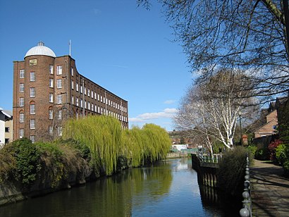
St James Mill Address: Norwich street in Norwich
Attractions near St James Mill
Naked Element,Nr3 1tn,John Jarrold Printing Museum,Nr3 1xu,Nr3 1su,Nr3 1up,Norwich Crown Court,Barrack Street,N O R C A S,Bishop's House Gardens,Jarrold Bridge,33 Charlton Road,Movieshak,Silver Road Community Centre,Smurfit Kappa,Centenary House,Mousehold Street, Norwich,Stew,Flamenco Dance with la Rubia,Smurfit (fishergate)How to get to popular attractions in Norwich with public transportation
Pleasurewood Hills, Waveney,Huntingdon Marriott Hotel, Huntingdonshire,Platform 7, Cambridge,Holiday Inn Norwich - North, Norwich,University Of East Anglia, Norwich,PS3 & PS4 Gym, Broadland,Nr4 7uy, South Norfolk,Zara, Cambridge,Norfolk and Norwich University Hospital, South Norfolk,Cherry Hinton Hall, Cambridge,Cambridge University Sports Centre, Cambridge,Needham Lake, Mid Suffolk,Sportspark, Norwich,Hunstanton Beach, King'S Lynn And West Norfolk,Reffley, King'S Lynn And West Norfolk,The Cricketers (Wetherspoon), Ipswich,Cb1 3df, Cambridge,Globe Hotel (Wetherspoon), King'S Lynn And West Norfolk,Littleport, East Cambridgeshire,Milton Country Park, South CambridgeshireGet around East Anglia by public transport!
Travelling around East Anglia has never been so easy. See step by step directions as you travel to any attraction, street or major public transport station. View bus and train timetables, arrival times, service alerts and detailed routes on a map, so you know exactly how to get to anywhere in East Anglia.
When travelling to any destination around East Anglia use Moovit's Live Directions with Get Off Notifications to know exactly where and how far to walk, how long to wait for your line , and how many stops are left. Moovit will alert you when it’s time to get off — no need to constantly re-check whether yours is the next stop.
Wondering how to use public transport in East Anglia or how to pay for public transport in East Anglia? Moovit public transport app can help you navigate your way with public transport easily, and at minimum cost. It includes public transport fees, ticket prices, and costs. Looking for a map of East Anglia public transport lines? Moovit public transport app shows all public transport maps in East Anglia with all Bus, Train and Ferry routes and stops on an interactive map.
East Anglia has 3 transport type(s), including: Bus, Train and Ferry, operated by several transport agencies, including National Rail, Ambassador Travel, Harwich Harbour Ferry, Stephensons of Essex, Villager Minibus Sharnbrook, The Voluntary Network, Dews Coaches, Lord's Travel, Felixstowe Ferry Boat Yard, Hadleigh Community Transport, Beestons, Fenland Association for Community Transport, First Norfolk & Suffolk, Mulleys Motorways, Halesworth Area Community Transport