Camps Bay stop - Thursday schedule
| Line | Direction | Time |
|---|---|---|
| RED CITY TOUR | V&A Waterfront | 07:20 |
| BLUE MINI PENINSULA TOUR | V&A Waterfront | 07:20 |
| RED CITY TOUR | V&A Waterfront | 07:40 |
| BLUE MINI PENINSULA TOUR | V&A Waterfront | 07:40 |
| RED CITY TOUR | V&A Waterfront | 08:00 |
| BLUE MINI PENINSULA TOUR | V&A Waterfront | 08:00 |
| RED CITY TOUR | V&A Waterfront | 08:20 |
| BLUE MINI PENINSULA TOUR | V&A Waterfront | 08:20 |
| RED CITY TOUR | V&A Waterfront | 08:40 |
| BLUE MINI PENINSULA TOUR | V&A Waterfront | 08:40 |
| BLUE MINI PENINSULA TOUR | V&A Waterfront | 08:50 |
| RED CITY TOUR | V&A Waterfront | 09:00 |
| RED CITY TOUR | V&A Waterfront | 09:20 |
| BLUE MINI PENINSULA TOUR | V&A Waterfront | 09:25 |
| RED CITY TOUR | V&A Waterfront | 09:40 |
| BLUE MINI PENINSULA TOUR | V&A Waterfront | 10:00 |
| RED CITY TOUR | V&A Waterfront | 10:00 |
| RED CITY TOUR | V&A Waterfront | 10:20 |
| BLUE MINI PENINSULA TOUR | V&A Waterfront | 10:35 |
| RED CITY TOUR | V&A Waterfront | 10:40 |
| RED CITY TOUR | V&A Waterfront | 11:00 |
| BLUE MINI PENINSULA TOUR | V&A Waterfront | 11:10 |
| RED CITY TOUR | V&A Waterfront | 11:20 |
| RED CITY TOUR | V&A Waterfront | 11:40 |
| BLUE MINI PENINSULA TOUR | V&A Waterfront | 11:45 |
Directions to Camps Bay (Goodwood) with public transport
The following transport lines have routes that pass near Camps Bay
How to get to Camps Bay by bus?
Click on the bus route to see step by step directions with maps, line arrival times and updated time schedules.
Bus stops near Camps Bay in Goodwood
- Whale Rock, 2 min walk,
- Camps Bay, 2 min walk,
Bus lines to Camps Bay in Goodwood
- 106, 106: Camps Bay (clockwise),
- 108, 108: Hangberg - Sea Point - Adderley,
- 109, 109: Hout Bay - Imizamo Yethu - Sea Point - Adderley,
- 107, Civic Centre,
What are the nearest stations to Camps Bay?
The nearest stations to Camps Bay are:
- Whale Rock is 113 meters away, 2 min walk.
- Camps Bay is 144 meters away, 2 min walk.
Which bus lines stop near Camps Bay?
These bus lines stop near Camps Bay: 107, 109, BLUE MINI PENINSULA TOUR.
What’s the nearest bus stop to Camps Bay in Goodwood?
The nearest bus stops to Camps Bay in Goodwood are Whale Rock and Camps Bay. The closest one is a 2 min walk away.
What time is the first bus to Camps Bay in Goodwood?
The 109 is the first bus that goes to Camps Bay in Goodwood. It stops nearby at 04:35.
What time is the last bus to Camps Bay in Goodwood?
The 108 is the last bus that goes to Camps Bay in Goodwood. It stops nearby at 20:10.
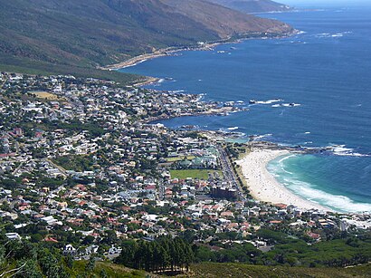
See Camps Bay, Goodwood, on the map
Public transport to Camps Bay stop (ID: CSS10) in Goodwood
Looking for directions to Camps Bay in Goodwood, South Africa?
Download the Moovit App to find the current schedule and step-by-step directions for Bus or Train routes that pass through Camps Bay.
Looking for the nearest stops closest to Camps Bay ? Check out this list of closest stops to your destination: Whale Rock; Camps Bay.
Bus: 107, 109, BLUE MINI PENINSULA TOUR, 106, 108.
We make riding on public transit to Camps Bay easy, which is why over 1.5 million users, including users in Goodwood trust Moovit as the best app for public transit.
Use the app to navigate to popular places including to the airport, hospital, stadium, grocery store, mall, coffee shop, school, college, and university.
Camps Bay stop’s code is CSS10
The first line to this stop is RED CITY TOUR, at 07:20, and the last line is RED CITY TOUR at 16:35.
This stop serves City Sightseeing Cpt’s lines
Popular routes from Camps Bay, Goodwood
Popular public transport stations in Goodwood
Get around Cape Town by public transport!
Travelling around Cape Town has never been so easy. See step by step directions as you travel to any attraction, street or major public transport station. View bus and train timetables, arrival times, service alerts and detailed routes on a map, so you know exactly how to get to anywhere in Cape Town.
When travelling to any destination around Cape Town use Moovit's Live Directions with Get Off Notifications to know exactly where and how far to walk, how long to wait for your line , and how many stops are left. Moovit will alert you when it’s time to get off — no need to constantly re-check whether yours is the next stop.
Wondering how to use public transport in Cape Town or how to pay for public transport in Cape Town? Moovit public transport app can help you navigate your way with public transport easily, and at minimum cost. It includes public transport fees, ticket prices, and costs. Looking for a map of Cape Town public transport lines? Moovit public transport app shows all public transport maps in Cape Town with all Bus, Train and Funicular routes and stops on an interactive map.
Cape Town has 3 transport type(s), including: Bus, Train and Funicular, operated by several transport agencies, including Golden Arrow, MyCiTi, Metrorail Western Cape, Intercape, City Sightseeing Cpt