Directions to Oriole Go Station (Toronto) with public transportation
The following transit lines have routes that pass near Oriole Go Station
How to get to Oriole Go Station by bus?
Click on the bus route to see step by step directions with maps, line arrival times and updated time schedules.
How to get to Oriole Go Station by train?
Click on the train route to see step by step directions with maps, line arrival times and updated time schedules.
How to get to Oriole Go Station by subway?
Click on the subway route to see step by step directions with maps, line arrival times and updated time schedules.
Bus stops near Oriole Go Station in Toronto
- Leslie St at Oriole Go Station South Side, 2 min walk,
- Woodsworth Rd at Northey Dr (East) - Walkway To Oriole Go Station, 7 min walk,
- Sheppard Ave East at Leslie St East Side - North York General Hospital, 8 min walk,
Subway stations near Oriole Go Station in Toronto
- Leslie, 27 min walk,
Train stations near Oriole Go Station in Toronto
- Oriole Go, 30 min walk,
Bus lines to Oriole Go Station in Toronto
- 51, Freshmeadow Dr at Don Mills Rd,
- 115, York Mills Station,
- 185, Don Mills Station,
- 385, Meadowvale Loop at Sheppard Ave East,
What are the closest stations to Oriole Go Station?
The closest stations to Oriole Go Station are:
- Leslie St at Oriole Go Station South Side is 113 meters away, 2 min walk.
- Woodsworth Rd at Northey Dr (East) - Walkway To Oriole Go Station is 484 meters away, 7 min walk.
- Sheppard Ave East at Leslie St East Side - North York General Hospital is 618 meters away, 8 min walk.
- Leslie is 2074 meters away, 27 min walk.
- Oriole Go is 2332 meters away, 30 min walk.
Which bus line stops near Oriole Go Station?
51
Which train line stops near Oriole Go Station?
RH
Which subway line stops near Oriole Go Station?
4
What’s the nearest subway station to Oriole Go Station in Toronto?
The nearest subway station to Oriole Go Station in Toronto is Leslie. It’s a 27 min walk away.
What’s the nearest train station to Oriole Go Station in Toronto?
The nearest train station to Oriole Go Station in Toronto is Oriole Go. It’s a 30 min walk away.
What’s the nearest bus stop to Oriole Go Station in Toronto?
The nearest bus stop to Oriole Go Station in Toronto is Leslie St at Oriole Go Station South Side. It’s a 2 min walk away.
What time is the first subway to Oriole Go Station in Toronto?
The 4 is the first subway that goes to Oriole Go Station in Toronto. It stops nearby at 5:31 AM.
What time is the last subway to Oriole Go Station in Toronto?
The 4 is the last subway that goes to Oriole Go Station in Toronto. It stops nearby at 2:30 AM.
What time is the first train to Oriole Go Station in Toronto?
The RH is the first train that goes to Oriole Go Station in Toronto. It stops nearby at 6:31 AM.
What time is the last train to Oriole Go Station in Toronto?
The RH is the last train that goes to Oriole Go Station in Toronto. It stops nearby at 7:13 PM.
What time is the first bus to Oriole Go Station in Toronto?
The 385 is the first bus that goes to Oriole Go Station in Toronto. It stops nearby at 3:23 AM.
What time is the last bus to Oriole Go Station in Toronto?
The 385 is the last bus that goes to Oriole Go Station in Toronto. It stops nearby at 2:54 AM.
How much is the subway fare to Oriole Go Station?
The subway fare to Oriole Go Station costs about $3.30.
How much is the bus fare to Oriole Go Station?
The bus fare to Oriole Go Station costs about $3.30 - $3.88.
How much is the Streetcar fare to Oriole Go Station?
The Streetcar fare to Oriole Go Station costs about $3.30.
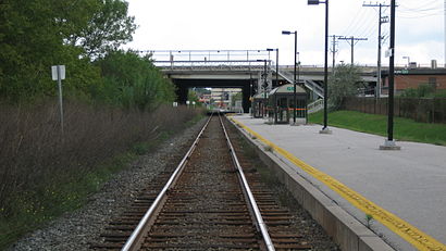
See Oriole Go Station, Toronto, on the map
Public Transit to Oriole Go Station in Toronto
How to get to Oriole Go Station in Toronto, Canada?
It’s easy with Moovit. Type in your street address and Moovit’s route finder will locate the fastest way to get you there! Not sure where to get off on the street? Download the Moovit App to find live directions (including where to get off on Oriole Go Station), see timetables and get the estimated arrival times for your favorite bus, subway, train or Streetcar lines.
Looking for the nearest stop or station to Oriole Go Station? Check out this list of closest stops available to your destination: Leslie St at Oriole Go Station South Side; Woodsworth Rd at Northey Dr (East) - Walkway To Oriole Go Station; Sheppard Ave East at Leslie St East Side - North York General Hospital; Leslie; Oriole Go.
Bus: 51, 115, 185, 385.Train: RH.Subway: 4.
Download the Moovit App to see the current schedule and routes available for Toronto. No need to install a special bus app to check the bus time or a train app to get train time. Moovit is the only all-in-one transit app that helps you get where you need to go.
We make riding on public transit to Oriole Go Station easy, which is why over 1.5 million users, including users in Toronto trust Moovit as the best app for public transit.
Use the app to navigate to popular places including to the airport, hospital, stadium, grocery store, mall, coffee shop, school, college, and university.
Location: Toronto
Streets near Oriole Go Station, Toronto
Access Road To Oriole Go Station Parking, Toronto,Esther Shiner Boulevard, Toronto,Northey Drive, Toronto,Shouldice Court, Toronto,Leslie North Ny Hospital Ramp, Toronto,Old Leslie Street, Toronto,Manorpark Court, Toronto,Leslie Bus Terminal, Toronto,Davean Drive, Toronto,Provost Drive, Toronto,Singer Court, Toronto,Ealing Drive, Toronto,Cheryl Shepway, Toronto,Havenbrook Boulevard, Toronto,Mcmahon Drive, Toronto,Stubbs Drive, Toronto,Woodsworth Road, Toronto,Tyson Shepway, Toronto,East Don Parkland, Toronto,Dunlace Drive, TorontoGet around Toronto by public transit!
Traveling around Toronto has never been so easy. See step by step directions as you travel to any attraction, street or major public transit station. View bus and train schedules, arrival times, service alerts and detailed routes on a map, so you know exactly how to get to anywhere in Toronto.
When traveling to any destination around Toronto use Moovit's Live Directions with Get Off Notifications to know exactly where and how far to walk, how long to wait for your line, and how many stops are left. Moovit will alert you when it's time to get off — no need to constantly re-check whether yours is the next stop.
Wondering how to use public transit in Toronto or how to pay for public transit in Toronto? Moovit public transit app can help you navigate your way with public transit easily, and at minimum cost. It includes public transit fees, ticket prices, and costs. Looking for a map of Toronto public transit lines? Moovit public transit app shows all public transit maps in Toronto with all Bus, Train, Subway, Streetcar and Ferry routes and stops on an interactive map.
Toronto has 5 transit type(s), including: Bus, Train, Subway, Streetcar and Ferry, operated by several transit agencies, including TTC, TTC Streetcar, Toronto Subway, Brampton Transit, MiWay, York Region Transit, GO Transit Bus, GO Transit, Durham Region Transit, UP Express, Grand River Transit, Guelph Transit, grt, Hamilton Street Railway, Burlington Transit