The Most Popular Urban Mobility App in Na H-Eileanan An Iar.
All local mobility options in one app
| Line | Direction | Time |
|---|---|---|
| W10 | Tarbert | 07:48 |
| W10 | Tarbert | 07:48 |
| W13 | Leverburgh | 09:01 |
| W13 | Leverburgh | 09:02 |
| W13 | Leverburgh | 12:24 |
| W13 | Rodel | 12:25 |
| W13 | Leverburgh | 14:59 |
| W13 | Leverburgh | 16:25 |
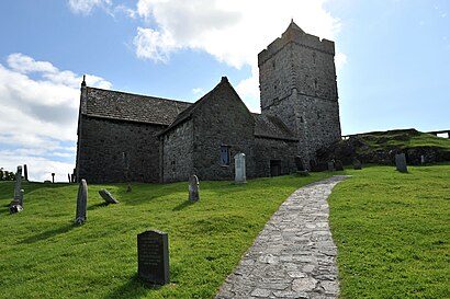
The following transport lines have routes that pass near St Clements Church, Rodel
The nearest stations to St Clements Church, Rodel are:
These Bus lines stop near St Clements Church, Rodel: W10
The nearest bus stop to St Clements Church, Rodel in Na H-Eileanan An Iar is Glen Rodel, Rodel. It’s a 13 min walk away.
The W10 is the first Bus that goes to St Clements Church, Rodel in Na H-Eileanan An Iar. It stops nearby at 07:46.
The W10 is the last Bus that goes to St Clements Church, Rodel in Na H-Eileanan An Iar. It stops nearby at 19:24.
Looking for directions to St Clements Church, Rodel in Na H-Eileanan An Iar, United Kingdom?
Download the Moovit App to find the current schedule and step-by-step directions for Bus or Ferry routes that pass through St Clements Church, Rodel.
Looking for the nearest stops closest to St Clements Church, Rodel ? Check out this list of closest stops to your destination: Glen Rodel.
Bus:
We make riding on public transit to St Clements Church, Rodel easy, which is why over 1.5 million users, including users in Na H-Eileanan An Iar trust Moovit as the best app for public transit.
Use the app to navigate to popular places including to the airport, hospital, stadium, grocery store, mall, coffee shop, school, college, and university.
St Clements Church, Rodel stop’s code is 6010731789
The first line to this stop is W10, at 07:48, and the last line is W13 at 16:25.
This stop serves South Harris Coaches and Lochs Motor Transport’s lines