Directions to Ayscoughfee (South Holland) with public transport
The following transport lines have routes that pass near Ayscoughfee
How to get to Ayscoughfee by bus?
Click on the bus route to see step by step directions with maps, line arrival times and updated time schedules.
Bus stations near Ayscoughfee in South Holland
- South Holland Centre, Spalding,2 min walk,
- Vine Street, Spalding,2 min walk,
- Chancery Court, Spalding,5 min walk,
- Broad Street, Spalding,5 min walk,
- Love Lane, Spalding,5 min walk,
- Grange Drive, Spalding,6 min walk,
Bus lines to Ayscoughfee in South Holland
- 301,Stamford,
- 302,Bourne,
- IT2|SPALDING INTO TOWN,Spalding,
- 37,Peterborough,
- G78,West Pinchbeck,
- S138S,Tydd St Giles,
- G76,Gosberton Risegate,
- S137S,Spalding,
- S139S,Sutton St James,
- B3,Spalding,
- NG1,Sutton Bridge,
What are the nearest stations to Ayscoughfee?
The nearest stations to Ayscoughfee are:
- South Holland Centre, Spalding is 58 meters away, 2 min walk.
- Vine Street, Spalding is 75 meters away, 2 min walk.
- Chancery Court, Spalding is 303 meters away, 5 min walk.
- Broad Street, Spalding is 304 meters away, 5 min walk.
- Love Lane, Spalding is 314 meters away, 5 min walk.
- Grange Drive, Spalding is 445 meters away, 6 min walk.
Which bus line stops near Ayscoughfee?
IT2|SPALDING INTO TOWN
What’s the nearest bus stop to Ayscoughfee in South Holland?
The nearest bus stops to Ayscoughfee in South Holland are South Holland Centre, Spalding and Vine Street, Spalding. The closest one is a 2 min walk away.
See Ayscoughfee, South Holland, on the map
Public Transit to Ayscoughfee in South Holland
Wondering how to get to Ayscoughfee in South Holland, United Kingdom? Moovit helps you find the best way to get to Ayscoughfee with step-by-step directions from the nearest public transit station.
Moovit provides free maps and live directions to help you navigate through your city. View schedules, routes, timetables, and find out how long does it take to get to Ayscoughfee in real time.
Looking for the nearest stop or station to Ayscoughfee? Check out this list of stops closest to your destination: South Holland Centre; Vine Street; Chancery Court; Broad Street; Love Lane; Grange Drive.
Bus:IT2|SPALDING INTO TOWN30130237G78S138SG76S137SS139S
Want to see if there’s another route that gets you there at an earlier time? Moovit helps you find alternative routes or times. Get directions from and directions to Ayscoughfee easily from the Moovit App or Website.
We make riding to Ayscoughfee easy, which is why over 1.5 million users, including users in South Holland, trust Moovit as the best app for public transit. You don’t need to download an individual bus app or train app, Moovit is your all-in-one transit app that helps you find the best bus time or train time available.
For information on prices of bus, costs and ride fares to Ayscoughfee, please check the Moovit app.
Use the app to navigate to popular places including to the airport, hospital, stadium, grocery store, mall, coffee shop, school, college, and university.
Ayscoughfee Address: Church Gate Spalding Spalding PE11 1 street in South Holland
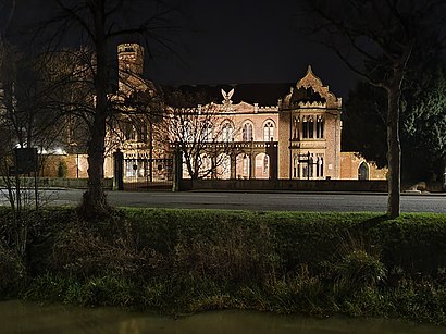
Ayscoughfee Hall (listen) is a grade I listed building and modest associated parkland in central Spalding, Lincolnshire, England, and is a landmark on the fen tour.Wiki
Attractions near Ayscoughfee
The Vista St Mary and St Nicolas Catering Committee,Ayscoughfee Hall Cafe,Silks,River Lodge B&B,David Bowman,Oakhouse Financial Services Limited,Equiptor,Essential Well-Being,High Bridge House,Karatespalding,Highbridge House (Highbridge Guest House),Essential Well-Being,D & M Tech Limited,Head Office Hair Design,The Crystal Inn,Rosewood Estate Agents,Bingham-Woods,Marstons,John Shields Detective Bureau,Everybody's Gym (Everybody S Gym Limited)How to get to popular attractions in South Holland with public transportation
Wyberton, Boston,The Watermill (Toby Carvery), Ashfield,Experian Embankment House, Nottingham,Daventry Court Hotel, Daventry,Horizon CDT, Nottingham,Steep Hill, Lincoln,Currys PC World, Nottingham,De Montfort University, Leicester,Sport Park Loughborough University, Charnwood,Morrisons, Bassetlaw,Blidworth, Newark And Sherwood,Lenton Boulevard, Nottingham,Wilko, Nottingham,The Showroom, Lincoln,Icon Centre, Daventry,St Margaret's Bus Station, Leicester,Highfields Park, Nottingham,Colwick Country Park, Nottingham,Kirby Muxloe, Blaby,Chequered Flag (Hungry Horse), CorbyGet around South Holland by public transport!
Travelling around South Holland has never been so easy. See step by step directions as you travel to any attraction, street or major public transport station. View bus and train timetables, arrival times, service alerts and detailed routes on a map, so you know exactly how to get to anywhere in South Holland.
When travelling to any destination around South Holland use Moovit's Live Directions with Get Off Notifications to know exactly where and how far to walk, how long to wait for your line , and how many stops are left. Moovit will alert you when it’s time to get off — no need to constantly re-check whether yours is the next stop.
Wondering how to use public transport in South Holland or how to pay for public transport in South Holland? Moovit public transport app can help you navigate your way with public transport easily, and at minimum cost. It includes public transport fees, ticket prices, and costs. Looking for a map of South Holland public transport lines? Moovit public transport app shows all public transport maps in South Holland with all bus routes and stops on an interactive map.
South Holland has 1 transport type(s), including: bus, operated by several transport agencies, including National Rail, Ashbourne Community Transport, Delaine Buses, Arriva Midlands, Centrebus, Our Centre, Hulleys of Baslow, D & G Bus, Stagecoach East Midlands, North Lincolnshire Council, National Rail, Roberts Coaches, Lawson's of Corby, Hawkes Coaches and East Yorkshire