See Bawsey, King'S Lynn And West Norfolk, on the map
Directions to Bawsey (King'S Lynn And West Norfolk) with public transport
The following transport lines have routes that pass near Bawsey
 Bus:
Bus:
How to get to Bawsey by bus?
Click on the bus route to see step by step directions with maps, line arrival times and updated time schedules.
Bus stations near Bawsey in King'S Lynn And West Norfolk
- Chilver House Lane, Bawsey,10 min walk,
Bus lines to Bawsey in King'S Lynn And West Norfolk
- 48,Grimston,
- 49A,Fakenham,
What are the nearest stations to Bawsey?
The nearest stations to Bawsey are:
- Chilver House Lane, Bawsey is 714 meters away, 10 min walk.
Which bus line stops near Bawsey?
48
What’s the nearest bus stop to Bawsey in King'S Lynn And West Norfolk?
The nearest bus stop to Bawsey in King'S Lynn And West Norfolk is Chilver House Lane, Bawsey. It’s a 10 min walk away.
What time is the first bus to Bawsey in King'S Lynn And West Norfolk?
The 49A is the first bus that goes to Bawsey in King'S Lynn And West Norfolk. It stops nearby at 07:43.
What time is the last bus to Bawsey in King'S Lynn And West Norfolk?
The 48 is the last bus that goes to Bawsey in King'S Lynn And West Norfolk. It stops nearby at 18:00.
See Bawsey, King'S Lynn And West Norfolk, on the map
Public Transit to Bawsey in King'S Lynn And West Norfolk
Wondering how to get to Bawsey in King'S Lynn And West Norfolk, United Kingdom? Moovit helps you find the best way to get to Bawsey with step-by-step directions from the nearest public transit station.
Moovit provides free maps and live directions to help you navigate through your city. View schedules, routes, timetables, and find out how long does it take to get to Bawsey in real time.
Looking for the nearest stop or station to Bawsey? Check out this list of stops closest to your destination: Chilver House Lane.
Bus:
Want to see if there’s another route that gets you there at an earlier time? Moovit helps you find alternative routes or times. Get directions from and directions to Bawsey easily from the Moovit App or Website.
We make riding to Bawsey easy, which is why over 1.5 million users, including users in King'S Lynn And West Norfolk, trust Moovit as the best app for public transit. You don’t need to download an individual bus app or train app, Moovit is your all-in-one transit app that helps you find the best bus time or train time available.
For information on prices of bus and train, costs and ride fares to Bawsey, please check the Moovit app.
Use the app to navigate to popular places including to the airport, hospital, stadium, grocery store, mall, coffee shop, school, college, and university.
Location: King'S Lynn And West Norfolk, East Anglia
Attractions near Bawsey
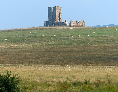
Brian R Goodison,Leziate Village Hall,Tax Analyst,Activate Financial Management,Sandringham Lawn Care,Leziate,Brundle Consulting,Innisfree Park Homes,Bawsey Estate & Country Park,The Pightle,Andy Graham Guitar Tutor,Ashwicken,Church Farm,Hardy HR Solutions,Pe32 1hb,Mintlyn Crematorium,Mintlyn Crematorium,Bawsey Ruin,Bawsey Crematorium,Pe32 1ddHow to get to popular attractions in King'S Lynn And West Norfolk with public transportation
Bluntisham, Huntingdonshire,Thickthorn Park and Ride, South Norfolk,Breydon Waters Holiday Park, Great Yarmouth,Glasswells, St Edmundsbury,Hellesdon, Norwich,ipl whitlesey, Fenland,Wicken Fen National Nature Reserve, East Cambridgeshire,Hunstanton Beach, King'S Lynn And West Norfolk,Woolpit, Mid Suffolk,Lucy Cavendish College, Cambridge,Kettle's Yard, Cambridge,Cambridge School of Visual & Performing Arts, Cambridge,Milsoms, Kesgrave Hall, Suffolk Coastal,Morston Quay, North Norfolk,UEA Congregation Hall, Norwich,Nowton Park, St Edmundsbury,Salthouse Harbour Hotel, Ipswich,Hunstanton,Scotsdales Garden Centre, South Cambridgeshire,Goals Soccer Centre, NorwichGet around King'S Lynn And West Norfolk by public transport!
Travelling around King'S Lynn And West Norfolk has never been so easy. See step by step directions as you travel to any attraction, street or major public transport station. View bus and train timetables, arrival times, service alerts and detailed routes on a map, so you know exactly how to get to anywhere in King'S Lynn And West Norfolk.
When travelling to any destination around King'S Lynn And West Norfolk use Moovit's Live Directions with Get Off Notifications to know exactly where and how far to walk, how long to wait for your line , and how many stops are left. Moovit will alert you when it’s time to get off — no need to constantly re-check whether yours is the next stop.
Wondering how to use public transport in King'S Lynn And West Norfolk or how to pay for public transport in King'S Lynn And West Norfolk? Moovit public transport app can help you navigate your way with public transport easily, and at minimum cost. It includes public transport fees, ticket prices, and costs. Looking for a map of King'S Lynn And West Norfolk public transport lines? Moovit public transport app shows all public transport maps in King'S Lynn And West Norfolk with all bus or train routes and stops on an interactive map.
King'S Lynn And West Norfolk has 2 transport type(s), including: bus or train, operated by several transport agencies, including National Rail, Ambassador Travel, Harwich Harbour Ferry, Stephensons of Essex, Villager Minibus Sharnbrook, The Voluntary Network, Dews Coaches, Felixstowe Ferry Boat Yard, Lord's Travel, Hadleigh Community Transport, Beestons, Fenland Association for Community Transport, First Norfolk & Suffolk, National Rail and Mulleys Motorways