See Belsize Park Station on the map
Directions to Belsize Park Station with public transportation
The following transport lines have routes that pass near Belsize Park Station
 Bus:
Bus: - Train:
- Tube:
How to get to Belsize Park Station by bus?
Click on the bus route to see step by step directions with maps, line arrival times and updated time schedules.
How to get to Belsize Park Station by train?
Click on the train route to see step by step directions with maps, line arrival times and updated time schedules.
How to get to Belsize Park Station by Tube?
Click on the Tube route to see step by step directions with maps, line arrival times and updated time schedules.
Bus stations near Belsize Park Station
- Downside Crescent (M),1 min walk,
- Haverstock Hill / Pond Street (F),6 min walk,
- Royal Free Hospital (C),9 min walk,
- Lawn Road (GU),10 min walk,
Tube stations near Belsize Park Station
- Hampstead,15 min walk,
- Swiss Cottage,16 min walk,
- Finchley Road,19 min walk,
Bus routes to Belsize Park Station
- 1,Canada Water,
- N5,Trafalgar Square,
- C11,Brent Cross, Shopping Centre,
- 268,Finchley Road, O2 Centre,
- 46,Paddington,
- 24,Hampstead Heath,
What are the nearest stations to Belsize Park Station?
The nearest stations to Belsize Park Station are:
- Downside Crescent (M) is 47 meters away, 1 min walk.
- Haverstock Hill / Pond Street (F) is 398 meters away, 6 min walk.
- Royal Free Hospital (C) is 616 meters away, 9 min walk.
- Lawn Road (GU) is 729 meters away, 10 min walk.
- Swiss Cottage is 1142 meters away, 16 min walk.
- Hampstead is 1152 meters away, 15 min walk.
- Finchley Road is 1416 meters away, 19 min walk.
Which bus lines stop near Belsize Park Station?
These bus lines stop near Belsize Park Station: 1, C11.
Which train line stops near Belsize Park Station?
OVERGROUND
Which Tube lines stop near Belsize Park Station?
These Tube lines stop near Belsize Park Station: JUBILEE, METROPOLITAN.
What’s the nearest Tube station to Belsize Park Station?
The nearest Tube station to Belsize Park Station is Swiss Cottage. It’s a 16 min walk away.
What’s the nearest bus stop to Belsize Park Station?
The nearest bus stop to Belsize Park Station is Downside Crescent (M). It’s a 1 min walk away.
What time is the first Tube to Belsize Park Station?
The METROPOLITAN is the first Tube that goes to Belsize Park Station. It stops nearby at 05:07.
What time is the last Tube to Belsize Park Station?
The METROPOLITAN is the last Tube that goes to Belsize Park Station. It stops nearby at 00:55.
What time is the first bus to Belsize Park Station?
The 24 is the first bus that goes to Belsize Park Station. It stops nearby at 03:08.
What time is the last bus to Belsize Park Station?
The 24 is the last bus that goes to Belsize Park Station. It stops nearby at 03:39.
See Belsize Park Station on the map
Public Transportation to Belsize Park Station
Wondering how to get to Belsize Park Station, United Kingdom? Moovit helps you find the best way to get to Belsize Park Station with step-by-step directions from the nearest public transit station.
Moovit provides free maps and live directions to help you navigate through your city. View schedules, routes, timetables, and find out how long does it take to get to Belsize Park Station in real time.
Looking for the nearest stop or station to Belsize Park Station? Check out this list of stops closest to your destination: Downside Crescent (M); Haverstock Hill / Pond Street (F); Royal Free Hospital (C); Lawn Road (GU); Swiss Cottage; Hampstead; Finchley Road.
Bus:Train:Tube:
Want to see if there’s another route that gets you there at an earlier time? Moovit helps you find alternative routes or times. Get directions from and directions to Belsize Park Station easily from the Moovit App or Website.
We make riding to Belsize Park Station easy, which is why over 1.5 million users, including users in Belsize Park, trust Moovit as the best app for public transit. You don’t need to download an individual bus app or train app, Moovit is your all-in-one transit app that helps you find the best bus time or train time available.
For information on prices of bus, train and Tube, costs and ride fares to Belsize Park Station, please check the Moovit app.
Use the app to navigate to popular places including to the airport, hospital, stadium, grocery store, mall, coffee shop, school, college, and university.
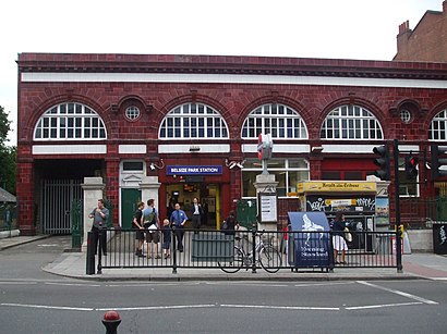
Belsize Park Station Address: Haverstock Hill NW3 London NW3 2 street in Belsize Park
Attractions near Belsize Park Station
Belsize Park,Belsize Park London Underground Station,Belsize Park Station (Stop L) (Belsize Park Underground Station),Belsize Park Underground Station,Clare Coffey Consulting,Gourmet Burger Kitchen,Chabad Lubavitch of Bournemouth,Roundford Limited,Post Office B de C,Nashdene Limited,Globe Tennis Club,Everyman Belsize Park,Hampstead Town Hall Centre,Nw3 4qp,Haverstock Hill Belsize,Hampstead Town Hall,Hillfield Court,VGG Accounting & Audit,Rosary R C Primary School (The Rosary Rc Primary School),End of the Line Terminal GearHow to get to popular attractions in Belsize Park with public transportation
Southgate, Southgate,Covent Garden Station, Covent Garden,Barnet, Finchley,Heathrow Terminal 3, Heathrow,Windsor Royal Shopping, Windsor,Goring-on-Thames, South Oxfordshire,Chinatown, Soho,Terminal 4, Heathrow,Brixton, Brixton,Issigonis House, Acton,Stratford Centre, Stratford,Oxford Brookes University Gipsy Lane Site, Oxford,Gatwick Airport, Crawley,John Radcliffe Main Hospital, Oxford,Westbourne Studios, Westbourne Park,Crouch End, Crouch End,Barking Station, Barking,Departure Lounge, Stansted,Kingston Hospital, Norbiton,Windsor Castle, WindsorGet around Belsize Park by public transport!
Travelling around Belsize Park has never been so easy. See step by step directions as you travel to any attraction, street or major public transport station. View bus and train timetables, arrival times, service alerts and detailed routes on a map, so you know exactly how to get to anywhere in Belsize Park.
When travelling to any destination around Belsize Park use Moovit's Live Directions with Get Off Notifications to know exactly where and how far to walk, how long to wait for your line , and how many stops are left. Moovit will alert you when it’s time to get off — no need to constantly re-check whether yours is the next stop.
Wondering how to use public transport in Belsize Park or how to pay for public transport in Belsize Park? Moovit public transport app can help you navigate your way with public transport easily, and at minimum cost. It includes public transport fees, ticket prices, and costs. Looking for a map of Belsize Park public transport lines? Moovit public transport app shows all public transport maps in Belsize Park with all bus, train or Tube routes and stops on an interactive map.
Belsize Park has 3 transport type(s), including: bus, train or Tube, operated by several transport agencies, including London Underground, London Buses, Transport for London, London Tramlink, Transport for London, National Rail, Bluestar, Berry's Coaches, Oxford Bus Company, Stagecoach West, Community First Wessex, Cresta Coaches, D & P Boat Hire, First Portsmouth, Fareham & Gosport and FYTbus