Directions to Bridge Of Don (Aberdeen) with public transport
The following transport lines have routes that pass near Bridge Of Don
How to get to Bridge Of Don by bus?
Click on the bus route to see step by step directions with maps, line arrival times and updated time schedules.
Bus stops near Bridge Of Don in Aberdeen
- Dubford Park, Bridge Of Don, 14 min walk,
- Broadfold Road, Bridge Of Don, 17 min walk,
- Newburgh Drive, Middleton, 20 min walk,
Bus lines to Bridge Of Don in Aberdeen
- 32, Bridge Of Don,
- 1B, RGU Garthdee/Bridge Street - Dubford,
- X60, Aberdeen - Ellon or Newburgh/Peterhead,
- 61, Aberdeen - Ellon/Peterhead,
- 62, Aberdeen - Ellon/Peterhead,
- X63, Aberdeen - Ellon or Newburgh/Peterhead,
- X67, Aberdeen - Ellon/Fraserburgh,
- 68, Aberdeen - Ellon/Fraserburgh,
- X68, Aberdeen - Ellon/Fraserburgh,
- 290, Aberdeen Union Square - Methlick,
- 291, Aberdeen Union Square - Methlick,
- 2, Garthdee,
What are the nearest stations to Bridge Of Don?
The nearest stations to Bridge Of Don are:
- Dubford Park, Bridge Of Don is 992 meters away, 14 min walk.
- Broadfold Road, Bridge Of Don is 1232 meters away, 17 min walk.
- Newburgh Drive, Middleton is 1452 meters away, 20 min walk.
Which bus line stops near Bridge Of Don?
2
What’s the nearest bus stop to Bridge Of Don in Aberdeen?
The nearest bus stop to Bridge Of Don in Aberdeen is Dubford Park, Bridge Of Don. It’s a 14 min walk away.
See Bridge Of Don, Aberdeen, on the map
Public Transit to Bridge Of Don in Aberdeen
Wondering how to get to Bridge Of Don in Aberdeen, United Kingdom? Moovit helps you find the best way to get to Bridge Of Don with step-by-step directions from the nearest public transit station.
Moovit provides free maps and live directions to help you navigate through your city. View schedules, routes, timetables, and find out how long does it take to get to Bridge Of Don in real time.
Looking for the nearest stop or station to Bridge Of Don? Check out this list of stops closest to your destination: Dubford Park; Broadfold Road; Newburgh Drive.
Bus: 2, 32, 1B, X60, 61, 62, X63.
Want to see if there’s another route that gets you there at an earlier time? Moovit helps you find alternative routes or times. Get directions from and directions to Bridge Of Don easily from the Moovit App or Website.
We make riding to Bridge Of Don easy, which is why over 1.5 million users, including users in Aberdeen, trust Moovit as the best app for public transit. You don’t need to download an individual bus app or train app, Moovit is your all-in-one transit app that helps you find the best bus time or train time available.
For information on prices of bus and train, costs and ride fares to Bridge Of Don, please check the Moovit app.
Use the app to navigate to popular places including to the airport, hospital, stadium, grocery store, mall, coffee shop, school, college, and university.
Bridge Of Don Address: Scotstown Road street in Aberdeen
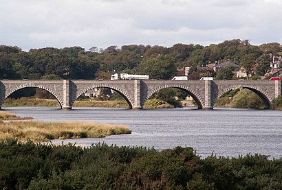
The Bridge of Don is a five-arch bridge of granite crossing the River Don just above its mouth in Aberdeen, Scotland.Wiki
Attractions near Bridge Of Don
Rsl Motors,Braehead,12 Cameron Way,100 Gordon Place,Clashieknowe (braehead clashieknowe),Alex Collie Sports and Community Centre,8 Cameron Avenue,Batleys Cash And Carry Aberdeen,8 Cameron Road,Cameron Road, Aberdeen,8 Cameron Drive,The Workshop @ Bis Salamis,Cameron Scotstown,Bridge of Don,Your Vision Building Services,Icing Design,Steven Sim Football Coaching,Scotstown Primary School,12 Cameron Terrace,Murison Commercials Ltd.How to get to popular attractions in Aberdeen with public transportation
BrewDog Glasgow, Glasgow,Corstorphine, Edinburgh,Marks & Spencer, Edinburgh,Dundee Bus Station, Dundee,Skyscanner, Edinburgh,Croy Railway Station (CRO), North Lanarkshire,John Lewis, Glasgow,Inverness Railway Station (INV), Inverness,Asda, Glasgow,Newton Mearns, Newton Mearns,England / Scotland Border, Carlisle District (B),Forth Bridge,Motherwell Railway Station (MTH), Motherwell,Dunfermline, Dunfermline,Kirkcaldy Bus Station, Kirkcaldy And Dysart,Buchanan Street Bus Station, Glasgow,Dunfermline Bus Station, Dunfermline,Ninewells Hospital, Dundee,Ninewells Hospital & Medical School, Dundee,Bruntsfield Links, EdinburghGet around Scotland by public transport!
Travelling around Scotland has never been so easy. See step by step directions as you travel to any attraction, street or major public transport station. View bus and train timetables, arrival times, service alerts and detailed routes on a map, so you know exactly how to get to anywhere in Scotland.
When travelling to any destination around Scotland use Moovit's Live Directions with Get Off Notifications to know exactly where and how far to walk, how long to wait for your line , and how many stops are left. Moovit will alert you when it’s time to get off — no need to constantly re-check whether yours is the next stop.
Wondering how to use public transport in Scotland or how to pay for public transport in Scotland? Moovit public transport app can help you navigate your way with public transport easily, and at minimum cost. It includes public transport fees, ticket prices, and costs. Looking for a map of Scotland public transport lines? Moovit public transport app shows all public transport maps in Scotland with all Bus, Train, Light rail and Ferry routes and stops on an interactive map.
Scotland has 4 transport type(s), including: Bus, Train, Light rail and Ferry, operated by several transport agencies, including First Greater Glasgow, First Aberdeen, Lothian Buses, McGill's Bus Service, Stagecoach East Scotland, Stagecoach Bluebird, Xplore Dundee, Community Transport Glasgow, Prentice Westwood, McCall's Coaches, J P Minibus, National Rail, R Robertson & Son, Burnbrae Garage, Ember