See Brigidine College Randwick on the map
Directions to Brigidine College Randwick with public transportation
The following transport lines have routes that pass near Brigidine College Randwick
- Bus:
- Train:
- Light rail:
How to get to Brigidine College Randwick by Bus?
Click on the Bus route to see step by step directions with maps, line arrival times and updated time schedules.
How to get to Brigidine College Randwick by Train?
Click on the Train route to see step by step directions with maps, line arrival times and updated time schedules.
Bus stations near Brigidine College Randwick
- Coogee Bay Rd at Perouse Rd,2 min walk,
- Coogee Bay Rd after Belmore Rd,2 min walk,
- Avoca St opp Sacred Heart Primary School,2 min walk,
- Belmore Rd at Avoca St,2 min walk,
- Sacred Heart Primary School, Avoca St,2 min walk,
- Perouse Rd at Aeolia St,3 min walk,
- Perouse Rd at Soudan St,3 min walk,
- Clara St at Blenheim St,3 min walk,
- Avoca St opp Randwick Girls High School,4 min walk,
- Randwick Girls High School, Avoca St, Stand A,5 min walk,
Light rail stations near Brigidine College Randwick
- Juniors Kingsford Light Rail,15 min walk,
- UNSW High Street Light Rail,17 min walk,
{{TRANSIT_TYPE}#Capitalized} routes to Brigidine College Randwick
- 370,Glebe Point,
- 619E,Maroubra Junction,
- 718E,Watsons Bay,
- 651E,Mascot to Brigidine College Randwick,
- 652E,Maroubra Junction to Brigidine College Randwick,
- 719E,Edgecliff to Sydney French School,
- 615E,Kingsford to Marcellin Senior,
- 616E,Perry St at Bunnerong Rd to Marcellin College,
- 623E,Randwick Boys HS to Bondi Junction,
- 629E,Randwick Boys HS to Clovelly Beach,
- 636E,Randwick High Schools to Gardeners & Botany Rds,
- 645E,Randwick High Schools to Albion & Macpherson Sts,
- 647E,Randwick High Schools to North Bondi,
- 650E,Brigidine College Randwick to Mascot,
- 654E,Little Bay to Brigidine College Randwick,
- 655E,Gardeners & Botany Rds to Brigidine College Randwick,
- 658E,La Perouse to Brigidine College Randwick,
- 697E,Dover Heights to Mount Sinai College,
- 348,Wolli Creek to Prince of Wales Hospital,
- 356,Eastgardens to Bondi Junction,
What are the nearest stations to Brigidine College Randwick?
The nearest stations to Brigidine College Randwick are:
- Coogee Bay Rd at Perouse Rd is 79 meters away, 2 min walk.
- Coogee Bay Rd after Belmore Rd is 85 meters away, 2 min walk.
- Avoca St opp Sacred Heart Primary School is 109 meters away, 2 min walk.
- Belmore Rd at Avoca St is 112 meters away, 2 min walk.
- Perouse Rd at Aeolia St is 115 meters away, 3 min walk.
- Sacred Heart Primary School, Avoca St is 125 meters away, 2 min walk.
- Perouse Rd at Soudan St is 141 meters away, 3 min walk.
- Clara St at Blenheim St is 202 meters away, 3 min walk.
- Avoca St opp Randwick Girls High School is 306 meters away, 4 min walk.
- Randwick Girls High School, Avoca St, Stand A is 377 meters away, 5 min walk.
- Juniors Kingsford Light Rail is 1127 meters away, 15 min walk.
- UNSW High Street Light Rail is 1323 meters away, 17 min walk.
Which Bus lines stop near Brigidine College Randwick?
These Bus lines stop near Brigidine College Randwick:Â 370, 373X, 377X
Which Train lines stop near Brigidine College Randwick?
These Train lines stop near Brigidine College Randwick:Â T4
Which Light rail lines stop near Brigidine College Randwick?
These Light rail lines stop near Brigidine College Randwick:Â L2
What’s the nearest light rail station to Brigidine College Randwick?
The nearest light rail station to Brigidine College Randwick is Juniors Kingsford Light Rail. It’s a 15 min walk away.
What’s the nearest bus stop to Brigidine College Randwick?
The nearest bus stops to Brigidine College Randwick are Coogee Bay Rd at Perouse Rd, Coogee Bay Rd after Belmore Rd, Avoca St opp Sacred Heart Primary School, Belmore Rd at Avoca St and Sacred Heart Primary School, Avoca St. The closest one is a 2 min walk away.
What time is the first Light rail to Brigidine College Randwick?
The L2 is the first Light rail that goes to Brigidine College Randwick. It stops nearby at 05:04.
What time is the last Light rail to Brigidine College Randwick?
The L2 is the last Light rail that goes to Brigidine College Randwick. It stops nearby at 01:39.
What time is the first Bus to Brigidine College Randwick?
The 373 is the first Bus that goes to Brigidine College Randwick. It stops nearby at 03:13.
What time is the last Bus to Brigidine College Randwick?
The 373 is the last Bus that goes to Brigidine College Randwick. It stops nearby at 03:15.
How much is the Bus fare to Brigidine College Randwick?
The Bus fare to Brigidine College Randwick costs about $2.24 - $5.33.
How much is the Light rail fare to Brigidine College Randwick?
The Light rail fare to Brigidine College Randwick costs about $2.24 - $5.33.
How much is the Train fare to Brigidine College Randwick?
The Train fare to Brigidine College Randwick costs about $2.80 - $7.65.
See Brigidine College Randwick on the map
Public Transportation to Brigidine College Randwick
Wondering how to get to Brigidine College Randwick, Australia? Moovit helps you find the best way to get to Brigidine College Randwick with step-by-step directions from the nearest public transit station.
Moovit provides free maps and live directions to help you navigate through your city. View schedules, routes, timetables, and find out how long does it take to get to Brigidine College Randwick in real time.
Looking for the nearest stop or station to Brigidine College Randwick? Check out this list of stops closest to your destination: Coogee Bay Rd at Perouse Rd; Coogee Bay Rd after Belmore Rd; Avoca St opp Sacred Heart Primary School; Belmore Rd at Avoca St; Perouse Rd at Aeolia St; Sacred Heart Primary School; Perouse Rd at Soudan St; Clara St at Blenheim St; Avoca St opp Randwick Girls High School; Randwick Girls High School; Juniors Kingsford Light Rail; UNSW High Street Light Rail.
Bus:Train:Light rail:
Want to see if there’s another route that gets you there at an earlier time? Moovit helps you find alternative routes or times. Get directions from and directions to Brigidine College Randwick easily from the Moovit App or Website.
We make riding to Brigidine College Randwick easy, which is why over 1.5 million users, including users in Randwick, trust Moovit as the best app for public transit. You don’t need to download an individual bus app or train app, Moovit is your all-in-one transit app that helps you find the best bus time or train time available.
For information on prices of Bus, Train and Light rail, costs and ride fares to Brigidine College Randwick, please check the Moovit app.
Use the app to navigate to popular places including to the airport, hospital, stadium, grocery store, mall, coffee shop, school, college, and university.
Location: Randwick, Sydney
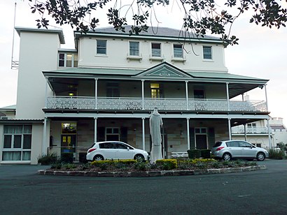
Brigidine College Randwick is an independent Roman Catholic secondary day school for girls located in Randwick, an eastern suburb of Sydney, New South Wales, Australia.Wiki
Attractions near Brigidine College Randwick
- The Spot
- Perouse Lodge
- Soul Burger
- Jarn Charm
- Randwick Ritz
- Royal Hotel
- The Ritz Cinema Randwick
- Claremont College
- Royal Hotel
- The Spot
- Saint Pauls Street
- Randwick Oral Surgery-Dr Frances Maloof
- Edmund Blackett Building Prince Of Wales Hospital
- Catherine Hayes Building
- McNevin Dickson Building
- Euroa Centre
- 22 Grams Cafe
- Avoca Street
- The Bright Alliance
- Wales Medical Centre
How to get to popular attractions in Randwick with public transportation
- Coogee, Coogee (NSW)
- UNSW, Kensington (NSW)
- Ms. G's, Potts Point
- Marquee, Pyrmont
- Coogee Pavilion, Coogee (NSW)
- Westfield Warringah Mall, Brookvale
- Helm Bar, Sydney
- Charlestown Square, Charlestown (NSW)
- Watsons Bay, Watsons Bay
- Toko, Surry Hills
- The Sheaf, Double Bay
- Narrabeen, Narrabeen
- Mortdale Station, Mortdale
- Kingsford Smith Airport - International Terminal, Mascot
- Westfield Miranda, Miranda (NSW)
- Castle Towers, Castle Hill (NSW)
- The Russian Club, Strathfield (NSW)
- University of Wollongong, Keiraville
- Rouse Hill Town Centre, Rouse Hill
- St Marys Station, St Marys (NSW)