Bury Interchange stop - Tuesday schedule
| Line | Direction | Time |
|---|---|---|
| 135 | Piccadilly Gardens | 04:25 |
| 163 | Piccadilly Gardens | 04:35 |
| 98 | Shudehill | 04:45 |
| 524 | Bolton | 04:45 |
| 135 | Piccadilly Gardens | 04:55 |
| 163 | Piccadilly Gardens | 05:00 |
| 472 | Ramsbottom | 05:00 |
| 471 | Rochdale | 05:03 |
| 98 | Shudehill | 05:04 |
| 135 | Piccadilly Gardens | 05:10 |
| 163 | Piccadilly Gardens | 05:15 |
| 524 | Bolton | 05:15 |
| 95 | Pendleton | 05:15 |
| 471 | Bolton | 05:20 |
| 135 | Piccadilly Gardens | 05:25 |
| 474 | Bury | 05:29 |
| 163 | Piccadilly Gardens | 05:30 |
| 97 | Shudehill | 05:30 |
| 474 | Ramsbottom | 05:30 |
| 471 | Rochdale | 05:33 |
| 94 | Unsworth | 05:34 |
| 98 | Shudehill | 05:34 |
| 524 | Bury | 05:35 |
| 472 | Ramsbottom | 05:36 |
| 135 | Piccadilly Gardens | 05:40 |
Directions to Bury Interchange with public transportation
The following transport lines have routes that pass near Bury Interchange
How to get to Bury Interchange by bus?
Click on the bus route to see step by step directions with maps, line arrival times and updated time schedules.
How to get to Bury Interchange by light rail?
Click on the light rail route to see step by step directions with maps, line arrival times and updated time schedules.
Bus stops near Bury Interchange
- Bury Museum (Stop Ms), 3 min walk,
- Mill Gate Shopping Centre (Stop Jj), 3 min walk,
- Trinity Street (Stop Hh), 4 min walk,
- Bury Town Hall (Stop Nn), 4 min walk,
- Bury Market (Stop Ff), 5 min walk,
- Bury Market (Stop Ee), 5 min walk,
- Bury Market (Stop Dd), 5 min walk,
- Tenterden Street (Stop Pp), 7 min walk,
Light Rail stations near Bury Interchange
- Bury (Manchester Metrolink), 20 min walk,
Bus routes to Bury Interchange
- TA2, Darwen,
- TA02, Harwood Lee,
- 469, Tottington - Bury,
- 471, Bolton - Rochdale,
- 472, Bury,
- 477, Ramsbottom - Bury,
- 480, Bolton - Bury,
- 511, Bolton - Bury,
- 512, Farnworth - Bury,
- 94, Manchester - Bury,
- 95, Salford - Bury,
- 97, Bury - Manchester,
- 135, Manchester - Bury,
- 513, Farnworth - Bury,
- 524, Bury - Bolton,
- 481, Bury - Blackburn,
- 483, Burnley - Bury,
- 487, Bury - Greenmount,
- 898, Bury,
- 163, Bury,
What are the nearest stations to Bury Interchange?
The nearest stations to Bury Interchange are:
- Bury Museum (Stop Ms) is 148 meters away, 3 min walk.
- Mill Gate Shopping Centre (Stop Jj) is 187 meters away, 3 min walk.
- Trinity Street (Stop Hh) is 240 meters away, 4 min walk.
- Bury Town Hall (Stop Nn) is 294 meters away, 4 min walk.
- Bury Market (Stop Ff) is 365 meters away, 5 min walk.
- Bury Market (Stop Ee) is 365 meters away, 5 min walk.
- Bury Market (Stop Dd) is 372 meters away, 5 min walk.
- Tenterden Street (Stop Pp) is 460 meters away, 7 min walk.
- Bury (Manchester Metrolink) is 1544 meters away, 20 min walk.
Which bus lines stop near Bury Interchange?
These bus lines stop near Bury Interchange: 135, 471, 98.
Which light rail line stops near Bury Interchange?
YELLOW LINE
What’s the nearest light rail station to Bury Interchange?
The nearest light rail station to Bury Interchange is Bury (Manchester Metrolink). It’s a 20 min walk away.
What’s the nearest bus stop to Bury Interchange?
The nearest bus stops to Bury Interchange are Bury Museum (Stop Ms) and Mill Gate Shopping Centre (Stop Jj). The closest one is a 3 min walk away.
What time is the first light rail to Bury Interchange?
The YELLOW LINE is the first light rail that goes to Bury Interchange. It stops nearby at 06:31.
What time is the last light rail to Bury Interchange?
The YELLOW LINE is the last light rail that goes to Bury Interchange. It stops nearby at 00:24.
What time is the first bus to Bury Interchange?
The 472 is the first bus that goes to Bury Interchange. It stops nearby at 06:00.
What time is the last bus to Bury Interchange?
The 472 is the last bus that goes to Bury Interchange. It stops nearby at 00:56.
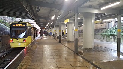
Bury Interchange station
 Taken by Anonymous
See Bury Interchange on the map
Public transport to Bury Interchange stop
Looking for directions to Bury Interchange in Bury, United Kingdom?
Download the Moovit App to find the current schedule and step-by-step directions for Bus or Light rail routes that pass through Bury Interchange.
Looking for the nearest stops closest to Bury Interchange ? Check out this list of closest stops to your destination: Bury Museum (Stop Ms); Mill Gate Shopping Centre (Stop Jj); Trinity Street (Stop Hh); Bury Town Hall (Stop Nn); Bury Market (Stop Ff); Bury Market (Stop Ee); Bury Market (Stop Dd); Tenterden Street (Stop Pp); Bury (Manchester Metrolink).
Bus: 135, 471, 98, TA2, TA02, 469, 472, 477, 480, 94, 95, 97, 513, 524, 481, 483, 487, 898, 163, 433, 467, 468, 475.Light rail: YELLOW LINE.
We make riding on public transit to Bury Interchange easy, which is why over 1.5 million users, including users in Bury trust Moovit as the best app for public transit.
Use the app to navigate to popular places including to the airport, hospital, stadium, grocery store, mall, coffee shop, school, college, and university.
The first line to this stop is 135, at 04:25, and the last line is 471 at 01:34.
This stop serves Bee Network, Bee Network, Bee Network, Bee Network and Rosso’s lines
Popular routes from Bury Interchange
Bus stops near Bury Interchange
Light Rail station near Bury Interchange
Popular public transport stations in Bury
Get around North West by public transport!
Travelling around North West has never been so easy. See step by step directions as you travel to any attraction, street or major public transport station. View bus and train timetables, arrival times, service alerts and detailed routes on a map, so you know exactly how to get to anywhere in North West.
When travelling to any destination around North West use Moovit's Live Directions with Get Off Notifications to know exactly where and how far to walk, how long to wait for your line , and how many stops are left. Moovit will alert you when it’s time to get off — no need to constantly re-check whether yours is the next stop.
Wondering how to use public transport in North West or how to pay for public transport in North West? Moovit public transport app can help you navigate your way with public transport easily, and at minimum cost. It includes public transport fees, ticket prices, and costs. Looking for a map of North West public transport lines? Moovit public transport app shows all public transport maps in North West with all Bus, Train, Light rail and Ferry routes and stops on an interactive map.
North West has 4 transport type(s), including: Bus, Train, Light rail and Ferry, operated by several transport agencies, including Stagecoach Manchester, Arriva North West, Diamond Bus North West, Stagecoach Merseyside and South Lancashire, Stagecoach Cumbria and North Lancashire, First Greater Manchester, First Halifax, National Express, Warrington's Own Buses, First Potteries, Rosso, Blackpool Transport, The Blackburn Bus Company, The Burnley Bus Company, Vision Bus