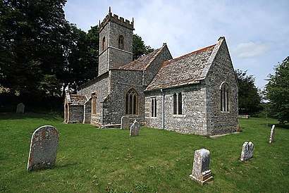
See Cheselbourne, West Dorset, on the map
Directions to Cheselbourne (West Dorset) with public transport
The following transport lines have routes that pass near Cheselbourne
Bus:
Bus stations near Cheselbourne in West Dorset
- Crawthorne Farm, Milborne St Andrew,67 min walk,
- Furzehill, Puddletown,74 min walk,
Bus lines to Cheselbourne in West Dorset
- 6,Tisbury,
- CR8,Blandford,
What are the nearest stations to Cheselbourne?
The nearest stations to Cheselbourne are:
- Crawthorne Farm, Milborne St Andrew is 5241 meters away, 67 min walk.
- Furzehill, Puddletown is 5772 meters away, 74 min walk.
Which Bus lines stop near Cheselbourne?
These Bus lines stop near Cheselbourne: X12
See Cheselbourne, West Dorset, on the map

Public Transit to Cheselbourne in West Dorset
Wondering how to get to Cheselbourne in West Dorset, United Kingdom? Moovit helps you find the best way to get to Cheselbourne with step-by-step directions from the nearest public transit station.
Moovit provides free maps and live directions to help you navigate through your city. View schedules, routes, timetables, and find out how long does it take to get to Cheselbourne in real time.
Looking for the nearest stop or station to Cheselbourne? Check out this list of stops closest to your destination: Crawthorne Farm; Furzehill.
Bus:
Want to see if there’s another route that gets you there at an earlier time? Moovit helps you find alternative routes or times. Get directions from and directions to Cheselbourne easily from the Moovit App or Website.
We make riding to Cheselbourne easy, which is why over 1.5 million users, including users in West Dorset, trust Moovit as the best app for public transit. You don’t need to download an individual bus app or train app, Moovit is your all-in-one transit app that helps you find the best bus time or train time available.
For information on prices of Bus and Train, costs and ride fares to Cheselbourne, please check the Moovit app.
Use the app to navigate to popular places including to the airport, hospital, stadium, grocery store, mall, coffee shop, school, college, and university.
Cheselbourne Address: Drake's Lane, Dorchester, Dorset DT2 7NS, UK street in West Dorset

Attractions near Cheselbourne
- Crawthorne
- Langham Wine Estate
- Crawthorne Farm, Milborne St Andrew
- Doles Ash Farm Holiday Cottages
- Milton Abbas Sewage Pumping Station
- Milton Abbey School
- Brown Bear Iron Works
- Wessex smart R
- Cornucopia Event Hire
- Milton Abbey Church and Landscape
- Greenacres Kennels & Cattery
- Milton Abbey School Entrance, Milton Abbas
- Smiths Dorset
- Milborne St Andrew
- Clubhouse1896
- Dorset Land Ro
- Castleman Hotel & Restaurant
- Sterck
- Three Little Pigs Luxury Cottage
- Match Community Lunches
How to get to popular attractions in West Dorset with public transportation
- Uwe Bower Ashton Campus, Bristol, City Of
- EE - Parkgate, South Gloucestershire
- DoubleTree by Hilton Hotel Bristol North, South Gloucestershire
- Boscombe Bus Station, Bournemouth
- De Vere Cotswold Water Park, Cotswold
- Bodmin, Cornwall
- Chaseside, Bournemouth
- Barnstaple Bus Station, North Devon
- Filton Abbey Wood Railway Station (FIT), South Gloucestershire
- Aviva, Eastleigh
- Cosmo Restaurant, Bristol, City Of
- Horfield Leisure Centre, Bristol, City Of
- Tiverton Parkway Railway Station (TVP), Mid Devon
- EE, South Hams
- HMS Collingwood, Fareham
- Cirencester, Cotswold
- Dyson Ltd., Wiltshire
- Swindon Marriott Hotel, Swindon
- JPMorgan, Bournemouth
- M5 Avonmouth Bridge