Directions to Circular Quay (Sydney) with public transport
The following transport lines have routes that pass near Circular Quay
How to get to Circular Quay by bus?
Click on the bus route to see step by step directions with maps, line arrival times and updated time schedules.
How to get to Circular Quay by train?
Click on the train route to see step by step directions with maps, line arrival times and updated time schedules.
Bus stops near Circular Quay in Sydney
- Circular Quay, Alfred St, Stand B, 7 min walk,
- Circular Quay, Alfred St, Stand A, 7 min walk,
- Art Gallery Rd opp Art Gallery of Nsw, 17 min walk,
- Argyle St at Kent St, 18 min walk,
- Wynyard Station, Jamison St, Stand U, 18 min walk,
- Wynyard Station, Carrington St, Stand B, 18 min walk,
- Wynyard Station, York St, Stand L, 18 min walk,
- Wynyard Station, Clarence St, Stand Q, 18 min walk,
- Wynyard Station, Carrington St, Stand C, 19 min walk,
- Wynyard Station, York St, Stand K, 19 min walk,
- Wynyard Station, Carrington St, Stand D, 19 min walk,
- Hickson Rd opp Towns Pl, 22 min walk,
- Admiralty House, Kirribilli Ave, 47 min walk,
Train stations near Circular Quay in Sydney
- Circular Quay, 8 min walk,
- Martin Place, 15 min walk,
- Wynyard, 18 min walk,
Ferry stations near Circular Quay in Sydney
- Kirribilli Wharf, 48 min walk,
Bus lines to Circular Quay in Sydney
- 333, North Bondi to City Circular Quay via Bondi Junction,
- 392N, Matraville to City Circular Quay (Night Service),
- 396, Maroubra Beach to City Circular Quay,
- 304, City Circular Quay via Green Square,
- 343, Rosebery,
- 441, Birchgrove via City Art Gallery,
- 311, City Millers Point,
- 165X, South Curl Curl,
- B1, B-Line Mona Vale to City Wynyard,
- BN1, B-Line Mona Vale to City QVB (Night Service),
- 194, St Ives to City QVB,
- 194X, St Ives to City QVB (Express Service),
- 22T1, Chatswood, then Artarmon, St Leonards, North Sydney, Wynyard and return,
- 270, Terrey Hills to City QVB,
- 271, Belrose to City QVB,
- 273, Killarney Heights to City QVB via Forestville,
- 274, City QVB to Davidson via Frenchs Forest,
- 607X, Bella Vista Station,
- 610X, Castle Hill Station,
- 613X, Bella Vista,
What are the nearest stations to Circular Quay?
The nearest stations to Circular Quay are:
- Circular Quay, Alfred St, Stand B is 495 meters away, 7 min walk.
- Circular Quay, Alfred St, Stand A is 533 meters away, 7 min walk.
- Circular Quay is 607 meters away, 8 min walk.
- Martin Place is 1171 meters away, 15 min walk.
- Art Gallery Rd opp Art Gallery of Nsw is 1280 meters away, 17 min walk.
- Argyle St at Kent St is 1335 meters away, 18 min walk.
- Wynyard Station, Jamison St, Stand U is 1342 meters away, 18 min walk.
- Wynyard is 1374 meters away, 18 min walk.
- Wynyard Station, Carrington St, Stand B is 1384 meters away, 18 min walk.
- Wynyard Station, York St, Stand L is 1388 meters away, 18 min walk.
- Wynyard Station, Clarence St, Stand Q is 1391 meters away, 18 min walk.
- Wynyard Station, Carrington St, Stand C is 1418 meters away, 19 min walk.
- Wynyard Station, York St, Stand K is 1444 meters away, 19 min walk.
- Wynyard Station, Carrington St, Stand D is 1452 meters away, 19 min walk.
- Hickson Rd opp Towns Pl is 1634 meters away, 22 min walk.
- Admiralty House, Kirribilli Ave is 3642 meters away, 47 min walk.
- Kirribilli Wharf is 3725 meters away, 48 min walk.
Which bus lines stop near Circular Quay?
These bus lines stop near Circular Quay: 207, 304, 333, 343, 377, 392, 396, B1.
Which train lines stop near Circular Quay?
These train lines stop near Circular Quay: T2, T8.
Which ferry lines stop near Circular Quay?
These ferry lines stop near Circular Quay: F1, F4.
What’s the nearest train station to Circular Quay in Sydney?
The nearest train station to Circular Quay in Sydney is Circular Quay. It’s a 8 min walk away.
What’s the nearest bus stop to Circular Quay in Sydney?
The nearest bus stops to Circular Quay in Sydney are Circular Quay, Alfred St, Stand B and Circular Quay, Alfred St, Stand A. The closest one is a 7 min walk away.
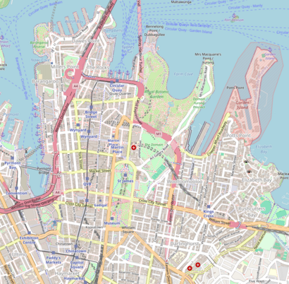
See Circular Quay, Sydney, on the map
Public Transit to Circular Quay in Sydney
Wondering how to get to Circular Quay in Sydney, Australia? Moovit helps you find the best way to get to Circular Quay with step-by-step directions from the nearest public transit station.
Moovit provides free maps and live directions to help you navigate through your city. View schedules, routes, timetables, and find out how long does it take to get to Circular Quay in real time.
Looking for the nearest stop or station to Circular Quay? Check out this list of stops closest to your destination: Circular Quay; Circular Quay; Circular Quay; Martin Place; Art Gallery Rd opp Art Gallery of Nsw; Argyle St at Kent St; Wynyard Station; Wynyard; Wynyard Station; Wynyard Station; Wynyard Station; Wynyard Station; Wynyard Station; Wynyard Station; Hickson Rd opp Towns Pl; Admiralty House; Kirribilli Wharf.
Bus: 207, 304, 333, 343, 377, 392, 396, B1, 392N.Train: T2, T8, T3, SCO, T4, M1, CCN, T1, T9.Ferry: F1, F4, F5.
Want to see if there’s another route that gets you there at an earlier time? Moovit helps you find alternative routes or times. Get directions from and directions to Circular Quay easily from the Moovit App or Website.
We make riding to Circular Quay easy, which is why over 1.5 million users, including users in Sydney, trust Moovit as the best app for public transit. You don’t need to download an individual bus app or train app, Moovit is your all-in-one transit app that helps you find the best bus time or train time available.
For information on prices of bus, train and ferry, costs and ride fares to Circular Quay, please check the Moovit app.
Use the app to navigate to popular places including to the airport, hospital, stadium, grocery store, mall, coffee shop, school, college, and university.
Circular Quay Address: Sydney NSW 2000 street in Sydney
Attractions near Circular Quay
Lower Concourse Opera House,Macquarie Street,Captain Cook Cruises,Meat & Cheese,Opera Bar,The Opera Bar, Circular Quay,Sydney Harbour Tunnel,Bennelong Point,Tarpeian Precinct Lawn - Royal Botanic Garden Sydney,悉尼歌剧院 (Sydney Opera House),Aria Restaurant,Dendy Cinemas Opera Quays,Manly Ferry,6a Circular Quay E,Taxi Stand,Aria,The East,Nuff Said,Sydney,悉尼How to get to popular attractions in Sydney with public transportation
Gosford Station (Main Concourse), Gosford,King Street Brewhouse, Sydney,Shady Pines Saloon, Darlinghurst,Charlestown Square Shopping Centre, Charlestown (NSW),Maroubra Beach, Maroubra,Heritage Belgian Beer Cafe, The Rocks (Sydney - NSW),Seven Hills Station (Concourse), Seven Hills (NSW),Dee Why, Dee Why,Zilver Restaurant, Haymarket,Manly Beach, Manly (NSW),West Ryde Station, West Ryde,Centro Bankstown, Bankstown,Cabramatta Station, Cabramatta,Petersham Station, Petersham,Westfield Eastgardens, Eastgardens,George Street, Sydney,Adriano Zumbo Pâtissier, Pyrmont,Chatswood Chase Shopping Centre, Chatswood,Fairfield Station, Fairfield (NSW),Westfield Mt Druitt, Mount DruittGet around Sydney by public transport!
Travelling around Sydney has never been so easy. See step by step directions as you travel to any attraction, street or major public transport station. View bus and train timetables, arrival times, service alerts and detailed routes on a map, so you know exactly how to get to anywhere in Sydney.
When travelling to any destination around Sydney use Moovit's Live Directions with Get Off Notifications to know exactly where and how far to walk, how long to wait for your line , and how many stops are left. Moovit will alert you when it’s time to get off — no need to constantly re-check whether yours is the next stop.
Wondering how to use public transport in Sydney or how to pay for public transport in Sydney? Moovit public transport app can help you navigate your way with public transport easily, and at minimum cost. It includes public transport fees, ticket prices, and costs. Looking for a map of Sydney public transport lines? Moovit public transport app shows all public transport maps in Sydney with all Bus, Train, Metro, Light rail and Ferry routes and stops on an interactive map.
Sydney has 5 transport type(s), including: Bus, Train, Metro, Light rail and Ferry, operated by several transport agencies, including Sydney Metro, Sydney Trains, Sydney Light Rail, Sydney Ferries, Intercity Trains, Intercity Train, NSW TrainLink, CDC NSW R14, U-Go Mobility, Keolis Downer Northern Beaches, Manly Fast Ferry, Transdev John Holland Buses, Busways, Busways North West, Dysons Buslines