Directions to Clarke Quay (Singapore) with public transport
The following transport lines have routes that pass near Clarke Quay
How to get to Clarke Quay by bus?
Click on the bus route to see step by step directions with maps, line arrival times and updated time schedules.
How to get to Clarke Quay by metro?
Click on the metro route to see step by step directions with maps, line arrival times and updated time schedules.
Metro station near Clarke Quay in Singapore
- Clarke Quay (NE5), 1 min walk,
Bus stops near Clarke Quay in Singapore
- Eu Tong Sen St - Clarke Quay Stn Exit E (04222), 2 min walk,
- New Bridge Rd - Opp Clarke Quay Stn (04239), 3 min walk,
- Eu Tong Sen St - Opp Hong Lim Pk (05023), 5 min walk,
- River Valley Rd - Clarke Quay (04211), 5 min walk,
- Sth Bridge Rd - Boat Quay (05029), 7 min walk,
- Upp Pickering St - Opp One Upp Pickering (05129), 7 min walk,
- Havelock Rd - Ctrl Sq (06189), 9 min walk,
Ferry stations near Clarke Quay in Singapore
- Eu Tong Sen Jetty, 5 min walk,
- Read Bridge Jetty, 6 min walk,
Bus lines to Clarke Quay in Singapore
- 2, Changi Village Ter ↔ Kg Bahru Ter,
- 12, Pasir Ris Int ↔ Kg Bahru Ter,
- 33, Bedok Int ↔ Kent Ridge Ter,
- 51, Hougang Ctrl Int ↔ Jurong East Int,
- 54, Bishan Int ↔ Kg Bahru Ter,
- 61, Bt Batok Int ↔ Eunos Int,
- 63, Eunos Int ↺ Jln Rumah Tinggi,
- 80, Sengkang Int ↔ HarbourFront Int,
- 124, St. Michael’s Ter ↔ HarbourFront Int,
- 145, Toa Payoh Int ↔ Buona Vista Ter,
- 147, Hougang Ctrl Int ↔ Clementi Int,
- 166, Ang Mo Kio Int ↔ Clementi Int,
- 174, Boon Lay Int ↔ Kg Bahru Ter,
- 190, Choa Chu Kang Int ↔ Kg Bahru Ter,
- 197, Bedok Int ↔ Jurong East Int,
- 851, Yishun Int ↔ Bt Merah Int,
- 961, Woodlands Temp Int ↔ Lor 1 Geylang Ter,
- 12E, Pasir Ris Int ↔ Kg Bahru Ter,
- 174E, [AM Peak]: Kg Bahru Ter [PM Peak]: Boon Lay Int,
- 851E, Yishun Int ↔ New Bridge Road,
What are the nearest stations to Clarke Quay?
The nearest stations to Clarke Quay are:
- Clarke Quay (NE5) is 67 meters away, 1 min walk.
- Eu Tong Sen St - Clarke Quay Stn Exit E (04222) is 127 meters away, 2 min walk.
- New Bridge Rd - Opp Clarke Quay Stn (04239) is 207 meters away, 3 min walk.
- Eu Tong Sen Jetty is 301 meters away, 5 min walk.
- Eu Tong Sen St - Opp Hong Lim Pk (05023) is 339 meters away, 5 min walk.
- River Valley Rd - Clarke Quay (04211) is 361 meters away, 5 min walk.
- Read Bridge Jetty is 418 meters away, 6 min walk.
- Sth Bridge Rd - Boat Quay (05029) is 480 meters away, 7 min walk.
- Upp Pickering St - Opp One Upp Pickering (05129) is 492 meters away, 7 min walk.
- Havelock Rd - Ctrl Sq (06189) is 628 meters away, 9 min walk.
Which bus lines stop near Clarke Quay?
These bus lines stop near Clarke Quay: 12E, 145, 147A, 174E, 190, 2, 575.
Which metro line stops near Clarke Quay?
NORTH EAST LINE (to ⑥ Harbourfront)
What’s the nearest metro station to Clarke Quay in Singapore?
The nearest metro station to Clarke Quay in Singapore is Clarke Quay (NE5). It’s a 1 min walk away.
What’s the nearest bus station to Clarke Quay in Singapore?
The nearest bus station to Clarke Quay in Singapore is Eu Tong Sen St - Clarke Quay Stn Exit E (04222). It’s a 2 min walk away.
What’s the nearest ferry station to Clarke Quay in Singapore?
The nearest ferry station to Clarke Quay in Singapore is Eu Tong Sen Jetty. It’s a 5 min walk away.
What time is the first metro to Clarke Quay in Singapore?
The NORTH EAST LINE is the first metro that goes to Clarke Quay in Singapore. It stops nearby at 06:05.
What time is the last metro to Clarke Quay in Singapore?
The NORTH EAST LINE is the last metro that goes to Clarke Quay in Singapore. It stops nearby at 00:02.
What time is the first bus to Clarke Quay in Singapore?
The 197 is the first bus that goes to Clarke Quay in Singapore. It stops nearby at 05:39.
What time is the last bus to Clarke Quay in Singapore?
The 961 is the last bus that goes to Clarke Quay in Singapore. It stops nearby at 01:04.
What time is the first ferry to Clarke Quay in Singapore?
The RIVER CRUISE BY WATERB is the first ferry that goes to Clarke Quay in Singapore. It stops nearby at 08:00.
What time is the last ferry to Clarke Quay in Singapore?
The SINGAPORE RIVER EXPERIENCE is the last ferry that goes to Clarke Quay in Singapore. It stops nearby at 22:44.
See Clarke Quay, Singapore, on the map
Public Transit to Clarke Quay in Singapore
Wondering how to get to Clarke Quay in Singapore? Moovit helps you find the best way to get to Clarke Quay with step-by-step directions from the nearest public transit station.
Moovit provides free maps and live directions to help you navigate through your city. View schedules, routes, timetables, and find out how long does it take to get to Clarke Quay in real time.
Looking for the nearest stop or station to Clarke Quay? Check out this list of stops closest to your destination: Clarke Quay (NE5); Eu Tong Sen St - Clarke Quay Stn Exit E (04222); New Bridge Rd - Opp Clarke Quay Stn (04239); Eu Tong Sen Jetty; Eu Tong Sen St - Opp Hong Lim Pk (05023); River Valley Rd - Clarke Quay (04211); Read Bridge Jetty; Sth Bridge Rd - Boat Quay (05029); Upp Pickering St - Opp One Upp Pickering (05129); Havelock Rd - Ctrl Sq (06189).
Bus: 12E, 145, 147A, 174E, 190, 2, 575, 12, 33, 51, 54, TS3, 32, 195, 195A, BIG BUS TOURS YELLOW LINE.Metro: NORTH EAST LINE.Ferry: RIVER CRUISE BY WATERB.
Want to see if there’s another route that gets you there at an earlier time? Moovit helps you find alternative routes or times. Get directions from and directions to Clarke Quay easily from the Moovit App or Website.
We make riding to Clarke Quay easy, which is why over 1.5 million users, including users in Singapore, trust Moovit as the best app for public transit. You don’t need to download an individual bus app or train app, Moovit is your all-in-one transit app that helps you find the best bus time or train time available.
For information on prices of bus and metro, costs and ride fares to Clarke Quay, please check the Moovit app.
Use the app to navigate to popular places including to the airport, hospital, stadium, grocery store, mall, coffee shop, school, college, and university.
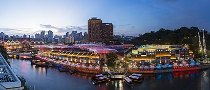
Clarke Quay Address: Eu Tong Sen Street street in Singapore
Clarke Quay is a historical riverside quay in Singapore, located within the Singapore River Planning Area. The quay is situated upstream from the mouth of the Singapore River and Boat Quay.Wiki
Places Near Clarke Quay (Singapore)
How to get to popular places in Singapore with public transport
Get around Singapore by public transport!
Travelling around Singapore has never been so easy. See step by step directions as you travel to any attraction, street or major public transport station. View bus and train timetables, arrival times, service alerts and detailed routes on a map, so you know exactly how to get to anywhere in Singapore.
When travelling to any destination around Singapore use Moovit's Live Directions with Get Off Notifications to know exactly where and how far to walk, how long to wait for your line , and how many stops are left. Moovit will alert you when it’s time to get off — no need to constantly re-check whether yours is the next stop.
Wondering how to use public transport in Singapore or how to pay for public transport in Singapore? Moovit public transport app can help you navigate your way with public transport easily, and at minimum cost. It includes public transport fees, ticket prices, and costs. Looking for a map of Singapore public transport lines? Moovit public transport app shows all public transport maps in Singapore with all Bus, Train, Metro, MRT & LRT, Ferry and Cable Car routes and stops on an interactive map.
Singapore has 6 transport type(s), including: Bus, Train, Metro, MRT & LRT, Ferry and Cable Car, operated by several transport agencies, including SMRT, SBS Transit, Tower Transit, Go-Ahead Singapore, Premium Bus, City Direct Bus, Changi Airport, Sentosa Development Corporation, Cross Border Bus, Singapore Cable Car Network, NUS Shuttle (ComfortDelGro), NTU Shuttle (ComfortDelGro), JTC Corp, Shuttle Bus (Appx. Schedule) and Tourist Bus (Book in Advance)