Dudley Port station - Thursday schedule
| Line | Direction | Time |
|---|---|---|
| WEST MIDLANDS RAILWAY | Rugeley Trent Valley | 05:41 |
| WEST MIDLANDS RAILWAY | Wolverhampton | 06:27 |
| WEST MIDLANDS RAILWAY | Birmingham New Street | 06:29 |
| WEST MIDLANDS RAILWAY | Wolverhampton | 06:57 |
| WEST MIDLANDS RAILWAY | Walsall | 06:59 |
| WEST MIDLANDS RAILWAY | Wolverhampton | 07:27 |
| WEST MIDLANDS RAILWAY | Walsall | 07:29 |
| WEST MIDLANDS RAILWAY | Wolverhampton | 07:57 |
| WEST MIDLANDS RAILWAY | Walsall | 07:59 |
| WEST MIDLANDS RAILWAY | Wolverhampton | 08:27 |
| WEST MIDLANDS RAILWAY | Walsall | 08:29 |
| WEST MIDLANDS RAILWAY | Wolverhampton | 08:57 |
| WEST MIDLANDS RAILWAY | Walsall | 08:59 |
| WEST MIDLANDS RAILWAY | Wolverhampton | 09:27 |
| WEST MIDLANDS RAILWAY | Walsall | 09:29 |
| WEST MIDLANDS RAILWAY | Wolverhampton | 09:57 |
| WEST MIDLANDS RAILWAY | Walsall | 09:59 |
| WEST MIDLANDS RAILWAY | Wolverhampton | 10:27 |
| WEST MIDLANDS RAILWAY | Walsall | 10:29 |
| WEST MIDLANDS RAILWAY | Wolverhampton | 10:57 |
| WEST MIDLANDS RAILWAY | Walsall | 10:59 |
| WEST MIDLANDS RAILWAY | Wolverhampton | 11:27 |
| WEST MIDLANDS RAILWAY | Walsall | 11:29 |
| WEST MIDLANDS RAILWAY | Wolverhampton | 11:57 |
| WEST MIDLANDS RAILWAY | Walsall | 11:59 |
See Dudley Port, Tipton Green, on the map
Directions to Dudley Port (Tipton Green) with public transport
The following transport lines have routes that pass near Dudley Port
 Bus:
Bus: - Train:
How to get to Dudley Port by bus?
Click on the bus route to see step by step directions with maps, line arrival times and updated time schedules.
How to get to Dudley Port by train?
Click on the train route to see step by step directions with maps, line arrival times and updated time schedules.
Bus stations near Dudley Port in Tipton Green
- Dudley Port Rail Station,2 min walk,
- Crompton Rd,8 min walk,
Light Rail stations near Dudley Port in Tipton Green
- Dartmouth Street,7 min walk,
Train stations near Dudley Port in Tipton Green
- Tipton,55 min walk,
Bus lines to Dudley Port in Tipton Green
- 74,Ladywood - St. James's,
- 74A,St. James's - West Bromwich Central,
- 229,Dudley,
What are the nearest stations to Dudley Port?
The nearest stations to Dudley Port are:
- Dudley Port Rail Station is 95 meters away, 2 min walk.
- Dartmouth Street is 447 meters away, 7 min walk.
- Crompton Rd is 556 meters away, 8 min walk.
- Tipton is 4240 meters away, 55 min walk.
Which bus line stops near Dudley Port?
74
Which train line stops near Dudley Port?
WEST MIDLANDS RAILWAY
What’s the nearest light rail station to Dudley Port in Tipton Green?
The nearest light rail station to Dudley Port in Tipton Green is Dartmouth Street. It’s a 7 min walk away.
What’s the nearest bus stop to Dudley Port in Tipton Green?
The nearest bus stop to Dudley Port in Tipton Green is Dudley Port Rail Station. It’s a 2 min walk away.
What time is the first light rail to Dudley Port in Tipton Green?
The METRO is the first light rail that goes to Dudley Port in Tipton Green. It stops nearby at 04:32.
What time is the last light rail to Dudley Port in Tipton Green?
The METRO is the last light rail that goes to Dudley Port in Tipton Green. It stops nearby at 01:08.
What time is the first train to Dudley Port in Tipton Green?
The WEST MIDLANDS RAILWAY is the first train that goes to Dudley Port in Tipton Green. It stops nearby at 05:38.
What time is the last train to Dudley Port in Tipton Green?
The WEST MIDLANDS RAILWAY is the last train that goes to Dudley Port in Tipton Green. It stops nearby at 00:20.
What time is the first bus to Dudley Port in Tipton Green?
The 74 is the first bus that goes to Dudley Port in Tipton Green. It stops nearby at 04:37.
What time is the last bus to Dudley Port in Tipton Green?
The 74 is the last bus that goes to Dudley Port in Tipton Green. It stops nearby at 00:23.
See Dudley Port, Tipton Green, on the map
Public transport to Dudley Port station in Tipton Green
Looking for directions to Dudley Port in Tipton Green, United Kingdom?
Download the Moovit App to find the current schedule and step-by-step directions for Bus or Train routes that pass through Dudley Port.
Looking for the nearest stops closest to Dudley Port ? Check out this list of closest stops to your destination: Dudley Port Rail Station; Dartmouth Street; Crompton Rd; Tipton.
Bus:Train:
We make riding on public transit to Dudley Port easy, which is why over 1.5 million users, including users in Tipton Green trust Moovit as the best app for public transit.
Use the app to navigate to popular places including to the airport, hospital, stadium, grocery store, mall, coffee shop, school, college, and university.
The station has the following entrances: Park Ln E and Dudley Port
The first line to this station is WEST MIDLANDS RAILWAY, at 05:41, and the last line is WEST MIDLANDS RAILWAY at 00:18.
Station Drive, Birmingham/Wolverhampton/Walsall/Dudley, England, United Kingdom
This station serves National Rail’s lines
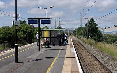
Dudley Port railway station serves the Dudley Port and Great Bridge areas of Tipton, West Midlands, England, Situated on the Stour Valley Line, the station is operated by West Midlands Railway.Wiki
Popular routes from Dudley Port, Tipton Green
Light Rail station near Dudley Port
Dartmouth StreetTrain station near Dudley Port
TiptonPopular public transport stations in Tipton Green
Sandwell Hospital (Stop Se),Bilston Fc,Museum Of the Gorge Car Park,Tally Ho Police Training,Sainsburys,Morrisons,Bermuda Park,Walstead Rd,Charlemont Ave,Hampton Road,Screwfix,Houndsfield Lane,The Lakes Railway Station,Chase Rd,Coventry Stadium,Baskerville House,Bishop Perowne School,Maxstoke Lane,Oldbury Cemetery,Clifford StreetGet around Tipton Green by public transport!
Travelling around Tipton Green has never been so easy. See step by step directions as you travel to any attraction, street or major public transport station. View bus and train timetables, arrival times, service alerts and detailed routes on a map, so you know exactly how to get to anywhere in Tipton Green.
When travelling to any destination around Tipton Green use Moovit's Live Directions with Get Off Notifications to know exactly where and how far to walk, how long to wait for your line , and how many stops are left. Moovit will alert you when it’s time to get off — no need to constantly re-check whether yours is the next stop.
Wondering how to use public transport in Tipton Green or how to pay for public transport in Tipton Green? Moovit public transport app can help you navigate your way with public transport easily, and at minimum cost. It includes public transport fees, ticket prices, and costs. Looking for a map of Tipton Green public transport lines? Moovit public transport app shows all public transport maps in Tipton Green with all bus or train routes and stops on an interactive map.
Tipton Green has 2 transport type(s), including: bus or train, operated by several transport agencies, including National Express West Midlands, National Express Coventry, National Express, Diamond Bus, Arriva Midlands, Stagecoach Midlands, West Midlands Metro, Stagecoach West, Stagecoach South Wales, First Potteries, First Worcestershire, LandFlight, trentbarton, D & G Bus and Flexibus