See Gouger Street, Adelaide, on the map
Directions to Gouger Street (Adelaide) with public transport
The following transport lines have routes that pass near Gouger Street
- Bus:
- Train:
How to get to Gouger Street by Bus?
Click on the Bus route to see step by step directions with maps, line arrival times and updated time schedules.
How to get to Gouger Street by Train?
Click on the Train route to see step by step directions with maps, line arrival times and updated time schedules.
Bus stations near Gouger Street in Adelaide
- Stop B2 Grote St - North side,1 min walk,
- Stop X1 Grote St - South side,2 min walk,
- Stop Y1 Sturt St - South side,6 min walk,
- Stop F1 West Tce - East side,6 min walk,
- Stop S1 West Tce - West side,6 min walk,
- Stop A1 Sir Donald Bradman Dr - North side,7 min walk,
- Stop B1 Sturt St - North side,7 min walk,
Light rail stations near Gouger Street in Adelaide
- Victoria Square,10 min walk,
- City West,12 min walk,
Train stations near Gouger Street in Adelaide
- Mile End,12 min walk,
Bus lines to Gouger Street in Adelaide
- 202,Ingle Farm to City,
- 202F,Ingle Farm to City,
- 203,Tea Tree Plaza Interchange to City,
- 203B,City to Ingle Farm,
- 203F,Tea Tree Plaza Interchange to City,
- 241,Marion Centre Interchange to City,
- 245,Hove to City,
- 248F,Marion Centre Interchange to City,
- 251,Mansfield Park to City,
- 252,Port Adelaide Interchange to City,
- 253,Mansfield Park to City,
- 254,Port Adelaide Interchange to City,
- N254,After Midnight Saturday PM - Sunday AM Semaphore to City,
- 262,Marion Centre Interchange to City,
- 719,Flinders University to City,
- 720,Old Reynella Interchange to City,
- 720H,Old Reynella Interchange to City,
- 721,Noarlunga Centre Interchange to City,
- 721F,Noarlunga Centre Interchange to City,
- N721,After Midnight Saturday PM - Sunday AM Seaford Centre to City,
What are the nearest stations to Gouger Street?
The nearest stations to Gouger Street are:
- Stop B2 Grote St - North side is 15 meters away, 1 min walk.
- Stop X1 Grote St - South side is 55 meters away, 2 min walk.
- Stop Y1 Sturt St - South side is 393 meters away, 6 min walk.
- Stop F1 West Tce - East side is 412 meters away, 6 min walk.
- Stop S1 West Tce - West side is 425 meters away, 6 min walk.
- Stop A1 Sir Donald Bradman Dr - North side is 507 meters away, 7 min walk.
- Stop B1 Sturt St - North side is 519 meters away, 7 min walk.
- Victoria Square is 706 meters away, 10 min walk.
- Mile End is 895 meters away, 12 min walk.
- City West is 898 meters away, 12 min walk.
Which Bus lines stop near Gouger Street?
These Bus lines stop near Gouger Street:Â 142, 253, 721, G10, H30S, M44
Which Train lines stop near Gouger Street?
These Train lines stop near Gouger Street:Â FLNDRS, OUTHA
What’s the nearest light rail station to Gouger Street in Adelaide?
The nearest light rail station to Gouger Street in Adelaide is Victoria Square. It’s a 10 min walk away.
What’s the nearest train station to Gouger Street in Adelaide?
The nearest train station to Gouger Street in Adelaide is Mile End. It’s a 12 min walk away.
What’s the nearest bus stop to Gouger Street in Adelaide?
The nearest bus stop to Gouger Street in Adelaide is Stop B2 Grote St - North side. It’s a 1 min walk away.
What time is the first Light rail to Gouger Street in Adelaide?
The GLNELG is the first Light rail that goes to Gouger Street in Adelaide. It stops nearby at 06:29.
What time is the last Light rail to Gouger Street in Adelaide?
The GLNELG is the last Light rail that goes to Gouger Street in Adelaide. It stops nearby at 00:53.
What time is the first Train to Gouger Street in Adelaide?
The FLNDRS is the first Train that goes to Gouger Street in Adelaide. It stops nearby at 06:19.
What time is the last Train to Gouger Street in Adelaide?
The BEL is the last Train that goes to Gouger Street in Adelaide. It stops nearby at 01:39.
What time is the first Bus to Gouger Street in Adelaide?
The N254 is the first Bus that goes to Gouger Street in Adelaide. It stops nearby at 03:00.
What time is the last Bus to Gouger Street in Adelaide?
The 168 is the last Bus that goes to Gouger Street in Adelaide. It stops nearby at 00:09.
How much is the Bus fare to Gouger Street?
The Bus fare to Gouger Street costs about $2.40 - $4.25.
How much is the Train fare to Gouger Street?
The Train fare to Gouger Street costs about $2.40.
See Gouger Street, Adelaide, on the map
Public Transit to Gouger Street in Adelaide
How to get to Gouger Street in Adelaide, Australia?
It’s easy with Moovit. Type in your street address and Moovit’s route finder will locate the fastest way to get you there! Not sure where to get off on the street? Download the Moovit App to find live directions (including where to get off on Gouger Street), see timetables and get the estimated arrival times for your favourite Bus, Train or Light rail lines.
Looking for the nearest stop or station to Gouger Street? Check out this list of closest stops available to your destination: Stop B2 Grote St - North side; Stop X1 Grote St - South side; Stop Y1 Sturt St - South side; Stop F1 West Tce - East side; Stop S1 West Tce - West side; Stop A1 Sir Donald Bradman Dr - North side; Stop B1 Sturt St - North side; Victoria Square; Mile End; City West.
Bus:Train:
Download the Moovit App to see the current schedule and routes available for Adelaide. No need to install a special bus app to check the bus time or a train app to get train time. Moovit is the only all-in-one transport app that helps you get where you need to go.
We make riding on public transit to Gouger Street easy, which is why over 1.5 million users, including users in Adelaide trust Moovit as the best app for public transport.
Use the app to navigate to popular places including to the airport, hospital, stadium, grocery store, mall, coffee shop, school, college, and university.
Location: Adelaide
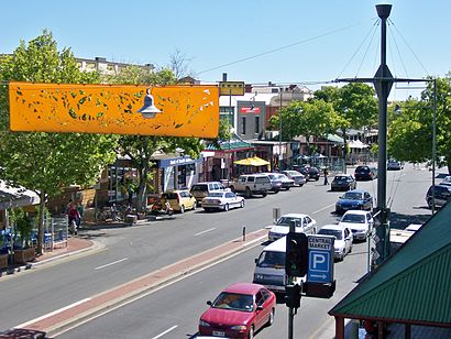
Gouger Street ( GUUJ-ər) is a major street in the centre of Adelaide, South Australia. It was named after Robert Gouger, the first Colonial Secretary of South Australia.Wiki
Streets near Gouger Street, Adelaide
- Monck Lane, Adelaide
- Hungry Jacks Drive Through Lane, Adelaide
- Murrays Lane, Adelaide
- Grote Street, Adelaide
- Mary Street, Adelaide
- Alfred Street, Adelaide
- Bailey Street, Adelaide
- Maud Street, Adelaide
- Rutland Place, Adelaide
- White Lane, Adelaide
- Wylde Road, Adelaide
- Blenheim Street, Adelaide
- Churchill Street, Adelaide
- Lowe Street, Adelaide
- Wright Street, Adelaide
- Ruthven Avenue, Adelaide
- Claxton Street, Adelaide
- Edward Street, Adelaide
- Marlborough Street, Adelaide
- Grattan Street, Adelaide
How to get to popular attractions in Adelaide with public transportation
- Flagstaff Hill, Flagstaff Hill
- Underdale High School, Underdale
- Glenunga International High Schol, Glenunga
- Cabra Dominican College, Cumberland Park
- South Australian Museum, Adelaide
- St Aloysius College, Adelaide
- Klemzig, Klemzig
- Alma Tavern, Norwood
- Brahma Lodge, Brahma Lodge
- Pirie Street, Adelaide
- Pullman Hotels, Adelaide
- Flinders Medical Centre Interchange, Bedford Park
- Mount Lofty, Crafers
- St. Francis Xavier Cathedral, Adelaide
- Central Markets, Adelaide
- Modbury Hospital, Modbury
- Lyell McEwin Hospital, Elizabeth Vale
- Blackwood Fitness, Blackwood
- Capri Cinema, Goodwood
- Blackwood Interchange, Blackwood