Headrow L stop - Saturday schedule
| Line | Direction | Time |
|---|---|---|
| 1 | Weetwood | 06:19 |
| 6 | Holt Park | 06:40 |
| 28 | Adel | 06:50 |
| 1 | Weetwood | 07:04 |
| 6 | Holt Park | 07:10 |
| 28 | Adel | 07:20 |
| 8 | Holt Park | 07:40 |
| 1 | Weetwood | 07:49 |
| 28 | Adel | 07:51 |
| 27 | Guiseley | 08:06 |
| 6 | Holt Park | 08:10 |
| 8 | Holt Park | 08:12 |
| 1 | Weetwood | 08:19 |
| 28 | Adel | 08:21 |
| 6 | Holt Park | 08:30 |
| 27 | Guiseley | 08:36 |
| 8 | Holt Park | 08:41 |
| 1 | Weetwood | 08:50 |
| 28 | Adel | 08:51 |
| 6 | Holt Park | 08:53 |
| 8 | Holt Park | 09:04 |
| 27 | Guiseley | 09:06 |
| 6 | Holt Park | 09:16 |
| 28 | Adel | 09:21 |
| 1 | Weetwood | 09:25 |
See Headrow L, Leeds, on the map
Directions to Headrow L (Leeds) with public transport
The following transport lines have routes that pass near Headrow L
 Bus:
Bus: - Train:
How to get to Headrow L by bus?
Click on the bus route to see step by step directions with maps, line arrival times and updated time schedules.
How to get to Headrow L by train?
Click on the train route to see step by step directions with maps, line arrival times and updated time schedules.
Bus stations near Headrow L in Leeds
- Headrow N,1 min walk,
- Headrow C,2 min walk,
- Merrion C,2 min walk,
- Headrow A,3 min walk,
- Headrow I,3 min walk,
- Headrow B,3 min walk,
- Merrion D,3 min walk,
- Civic L,5 min walk,
Train stations near Headrow L in Leeds
- Leeds,38 min walk,
Bus lines to Headrow L in Leeds
- 5,Halton Moor,
- 5A,Halton Moor,
- 56,Leeds City Centre,
- X84,Leeds City Centre,
- 874,Wetherby,
- 49,Seacroft,
- 50,Seacroft,
- 50A,Horsforth,
- AG50,Moor Grange,
- 1,Beeston,
- 1B,Beckett Park,
- N1,Leeds City Centre,
- 6,Leeds City Centre,
- 8,Leeds City Centre,
- 27,Leeds City Centre,
- 28,Adel,
- 42,Farnley,
- X6,Leeds - Bradford,
- 33,Leeds,
- 34,Leeds - Otley,
What are the nearest stations to Headrow L?
The nearest stations to Headrow L are:
- Headrow N is 12 meters away, 1 min walk.
- Headrow C is 98 meters away, 2 min walk.
- Merrion C is 123 meters away, 2 min walk.
- Headrow A is 160 meters away, 3 min walk.
- Headrow I is 163 meters away, 3 min walk.
- Headrow B is 179 meters away, 3 min walk.
- Merrion D is 188 meters away, 3 min walk.
- Civic L is 314 meters away, 5 min walk.
- Leeds is 2947 meters away, 38 min walk.
Which bus lines stop near Headrow L?
These bus lines stop near Headrow L: 1, 2, 201, 229, 34, 508, 52, 60A, A1, X6.
Which train line stops near Headrow L?
NORTHERN
What’s the nearest bus stop to Headrow L in Leeds?
The nearest bus stop to Headrow L in Leeds is Headrow N. It’s a 1 min walk away.
What time is the first train to Headrow L in Leeds?
The TRANSPENNINE EXPRESS is the first train that goes to Headrow L in Leeds. It stops nearby at 03:18.
What time is the last train to Headrow L in Leeds?
The TRANSPENNINE EXPRESS is the last train that goes to Headrow L in Leeds. It stops nearby at 03:17.
What time is the first bus to Headrow L in Leeds?
The 72 is the first bus that goes to Headrow L in Leeds. It stops nearby at 04:48.
What time is the last bus to Headrow L in Leeds?
The N1 is the last bus that goes to Headrow L in Leeds. It stops nearby at 02:48.
How much is the train fare to Headrow L?
The train fare to Headrow L costs about £5.30.
See Headrow L, Leeds, on the map
Public transport to Headrow L stop (ID: 45010921) in Leeds
Looking for directions to Headrow L in Leeds, United Kingdom?
Download the Moovit App to find the current schedule and step-by-step directions for Bus or Train routes that pass through Headrow L.
Looking for the nearest stops closest to Headrow L ? Check out this list of closest stops to your destination: Headrow N; Headrow C; Merrion C; Headrow A; Headrow I; Headrow B; Merrion D; Civic L; Leeds.
Bus:Train:
We make riding on public transit to Headrow L easy, which is why over 1.5 million users, including users in Leeds trust Moovit as the best app for public transit.
Use the app to navigate to popular places including to the airport, hospital, stadium, grocery store, mall, coffee shop, school, college, and university.
Headrow L stop’s code is 45010921
The first line to this stop is 1, at 06:19, and the last line is N1 at 02:34.
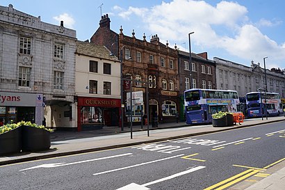
Albion Street, Leeds, England, United Kingdom
This stop serves First Leeds’s lines
Popular routes to Headrow L, Leeds
Popular routes from Headrow L, Leeds
Bus stops near Headrow L
Headrow N,Headrow C,Merrion C,Headrow A,Headrow I,Headrow B,Merrion D,Civic LTrain station near Headrow L
LeedsPopular public transport stations in Leeds
Waterdale/Wood Street,Norton Avenue/Lightwood Lane,Asda Wakefield,Wellington C,Domestic Road,Civic Centre,Warren Vale/Kilnhurst Road,Park Street/Market Place,Fox View (Stop A),Cathedral Retail Park D,Waterdale/College Road,Arundel Gate/Ag6,Monks Cross Park And Ride,Swinton (South Yorks),Europa Link/Europa View,St James's Hospital,Thornbury Barracks,Corton Wood/Dearne Valley Parkway,White Lee Road,Elland Wood BottomGet around Leeds by public transport!
Travelling around Leeds has never been so easy. See step by step directions as you travel to any attraction, street or major public transport station. View bus and train timetables, arrival times, service alerts and detailed routes on a map, so you know exactly how to get to anywhere in Leeds.
When travelling to any destination around Leeds use Moovit's Live Directions with Get Off Notifications to know exactly where and how far to walk, how long to wait for your line , and how many stops are left. Moovit will alert you when it’s time to get off — no need to constantly re-check whether yours is the next stop.
Wondering how to use public transport in Leeds or how to pay for public transport in Leeds? Moovit public transport app can help you navigate your way with public transport easily, and at minimum cost. It includes public transport fees, ticket prices, and costs. Looking for a map of Leeds public transport lines? Moovit public transport app shows all public transport maps in Leeds with all bus or train routes and stops on an interactive map.
Leeds has 2 transport type(s), including: bus or train, operated by several transport agencies, including First Leeds, First South Yorkshire, First York, First West Yorkshire Ltd, Arriva Yorkshire, Stagecoach Yorkshire, National Rail, First Bradford, First Halifax, Calder Valley & Huddersfield, East Yorkshire, The Keighley Bus Company, South Yorkshire Future Tram, The Harrogate Bus Company, National Rail and TM Travel