North West Terrace stop - Saturday schedule
| Line | Direction | Time |
|---|---|---|
| 9A | Asda Superstore, Stop T6 | 07:23 |
| 98 | Ball Green | 08:07 |
| 9 | Wharf Road | 08:08 |
| 9A | Asda Superstore, Stop T6 | 08:23 |
| 98 | Ball Green | 08:43 |
| 8A | Stoney Lane | 08:53 |
| 9A | Asda Superstore, Stop T6 | 08:53 |
| 9 | Wharf Road | 09:08 |
| 98 | Ball Green | 09:11 |
| 9A | Asda Superstore, Stop T6 | 09:23 |
| 9 | Wharf Road | 09:38 |
| 98 | Ball Green | 09:40 |
| 8A | Stoney Lane | 09:53 |
| 9A | Asda Superstore, Stop T6 | 09:53 |
| 9 | Wharf Road | 10:08 |
| 98 | Ball Green | 10:11 |
| 90 | Wilding Road Shops | 10:15 |
| 9A | Asda Superstore, Stop T6 | 10:23 |
| 9 | Wharf Road | 10:38 |
| 98 | Ball Green | 10:41 |
| 8A | Stoney Lane | 10:53 |
| 9A | Asda Superstore, Stop T6 | 10:53 |
| 9 | Wharf Road | 11:08 |
| 98 | Ball Green | 11:13 |
| 90 | Wilding Road Shops | 11:15 |
Directions to High Lane stop (Ford Green And Smallthorne) with public transport
The following transport lines have routes that pass near High Lane
 Bus: 8A, 98, 9A, 8, 9.
- Train: EAST MIDLANDS RAILWAY, NORTHERN, WEST MIDLANDS RAILWAY.
How to get to High Lane stop by bus?
Click on the bus route to see step by step directions with maps, line arrival times and updated time schedules.
Bus stops near High Lane stop in Ford Green And Smallthorne
- St Saviour's Church, 1 min walk,
- Community Centre, 4 min walk,
- Nettlebank, 5 min walk,
Train stations near High Lane station in Ford Green And Smallthorne
- Longport, 53 min walk,
Bus lines to High Lane stop in Ford Green And Smallthorne
- 8, Baddeley, Milton And Norton - Etruria And Hanley,
- 8A, Brown Edge And Endon - Etruria And Hanley,
- 9, Great Chell And Packmoor - Town,
- 9, Biddulph West - Westbury Park & Northwood,
- 9A, Tunstall - Etruria And Hanley,
- 90, Baddeley, Milton And Norton - Tunstall,
- 98, Baddeley, Milton And Norton - Town,
- 62, Wilding Road Shops,
- 7, Queen Street,
- 7, Kidsgrove,
- 7A, Hanley (City Cent),
- 7A, Wharf Road,
- 24, Shops,
What are the nearest stations to High Lane?
The nearest stations to High Lane are:
- St Saviour's Church is 41 meters away, 1 min walk.
- Community Centre is 242 meters away, 4 min walk.
- Nettlebank is 328 meters away, 5 min walk.
- Longport is 4119 meters away, 53 min walk.
Which bus lines stop near High Lane?
These bus lines stop near High Lane: 8A, 98, 9A.
What’s the nearest bus station to High Lane in Ford Green And Smallthorne?
The nearest bus station to High Lane in Ford Green And Smallthorne is St Saviour's Church. It’s a 1 min walk away.
What time is the first train to High Lane in Ford Green And Smallthorne?
The WEST MIDLANDS RAILWAY is the first train that goes to High Lane in Ford Green And Smallthorne. It stops nearby at 06:05.
What time is the last train to High Lane in Ford Green And Smallthorne?
The WEST MIDLANDS RAILWAY is the last train that goes to High Lane in Ford Green And Smallthorne. It stops nearby at 23:05.
What time is the first bus to High Lane in Ford Green And Smallthorne?
The 24 is the first bus that goes to High Lane in Ford Green And Smallthorne. It stops nearby at 05:08.
What time is the last bus to High Lane in Ford Green And Smallthorne?
The 9 is the last bus that goes to High Lane in Ford Green And Smallthorne. It stops nearby at 23:23.
High Lane station
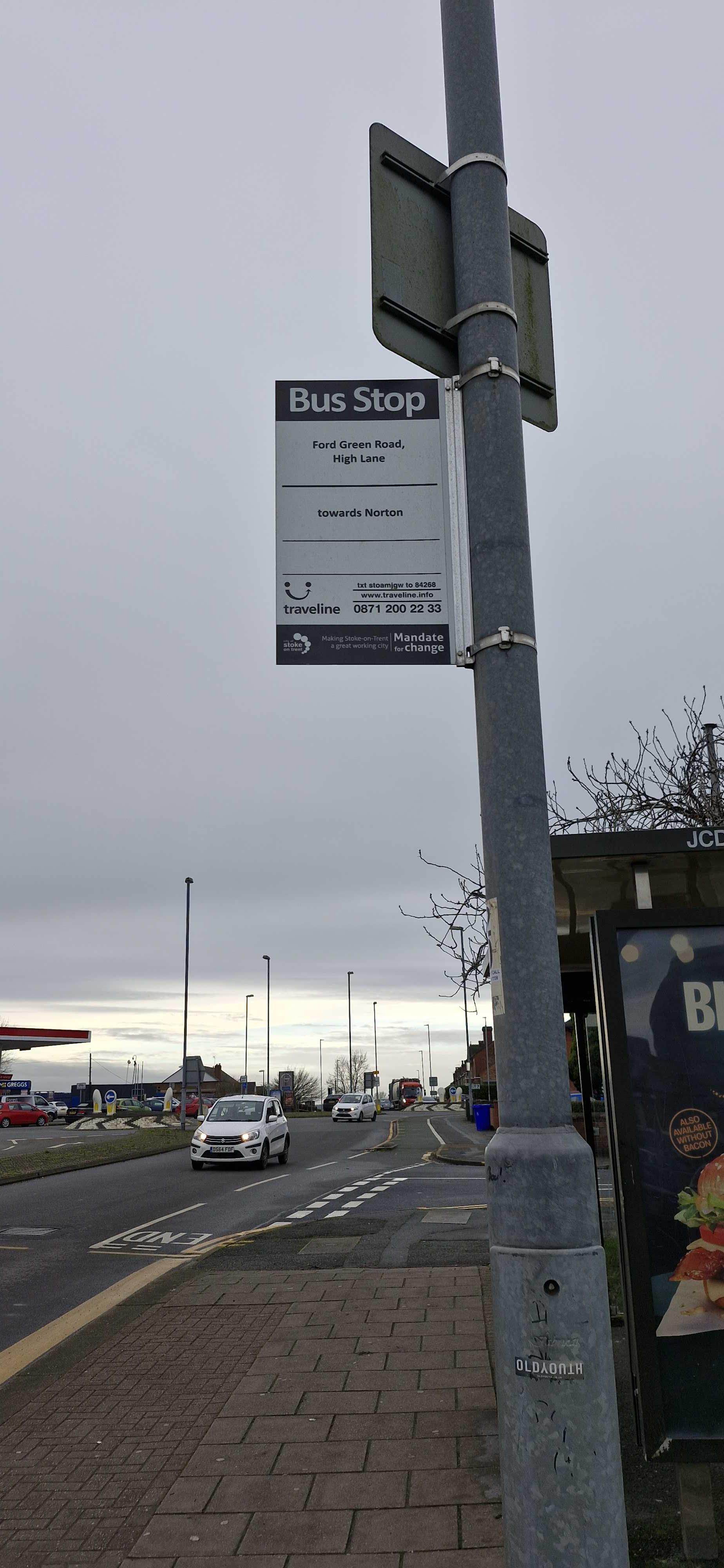 Taken by Anonymous
See High Lane stop, Ford Green And Smallthorne, on the map
Public transport to North West Terrace stop (ID: stoamjgw) in Ford Green And Smallthorne
Looking for directions to High Lane in Ford Green And Smallthorne, United Kingdom?
Download the Moovit App to find the current schedule and step-by-step directions for Bus routes that pass through High Lane.
Looking for the nearest stops closest to High Lane ? Check out this list of closest stops to your destination: St Saviour's Church; Community Centre; Nettlebank; Longport.
Bus: 8A, 98, 9A, 8, 9, 9, 62, 7, 7, 7A, 7A, 24.Train: EAST MIDLANDS RAILWAY, NORTHERN, WEST MIDLANDS RAILWAY.
We make riding on public transit to High Lane easy, which is why over 1.5 million users, including users in Ford Green And Smallthorne trust Moovit as the best app for public transit.
Use the app to navigate to popular places including to the airport, hospital, stadium, grocery store, mall, coffee shop, school, college, and university.
North West Terrace stop’s code is stoamjgw
The first line to this stop is 9A, at 07:23, and the last line is 8A at 20:48.
Ford Green Road, Stoke-On-Trent, England, United Kingdom
This stop serves First Potteries, D & G Bus and Stanton of Stoke’s lines
- St Saviour's Church,
- Community Centre,
- Nettlebank
Bus stops near High Lane stop
- Longport
Train station near High Lane station
- Wolverhampton,
- Winchester,
- Solihull Ice Rink,
- Aldridge Road,
- Asda Superstore,
- Cromwell Lane,
- Bull & Butcher,
- St John Wall School,
- Olton,
- Bacchus Road,
- Lichfield City,
- Warstock Community Centre,
- Chase Rd,
- Dartmouth St,
- Sandwell & Dudley Station,
- Ninian Way,
- Cockshut Hill School,
- Tally Ho Police Training,
- Mcarthurglen Retail Outlet,
- Crescent Theatre
Popular public transport stations in Ford Green And Smallthorne
Get around Ford Green And Smallthorne by public transport!
Travelling around Ford Green And Smallthorne has never been so easy. See step by step directions as you travel to any attraction, street or major public transport station. View bus and train timetables, arrival times, service alerts and detailed routes on a map, so you know exactly how to get to anywhere in Ford Green And Smallthorne.
When travelling to any destination around Ford Green And Smallthorne use Moovit's Live Directions with Get Off Notifications to know exactly where and how far to walk, how long to wait for your line , and how many stops are left. Moovit will alert you when it’s time to get off — no need to constantly re-check whether yours is the next stop.
Wondering how to use public transport in Ford Green And Smallthorne or how to pay for public transport in Ford Green And Smallthorne? Moovit public transport app can help you navigate your way with public transport easily, and at minimum cost. It includes public transport fees, ticket prices, and costs. Looking for a map of Ford Green And Smallthorne public transport lines? Moovit public transport app shows all public transport maps in Ford Green And Smallthorne with all Bus, Train and Light rail routes and stops on an interactive map.
West Midlands has 3 transport type(s), including: Bus, Train and Light rail, operated by several transport agencies, including National Express West Midlands, National Express Coventry, National Express, Diamond Bus, Arriva Midlands, Stagecoach Midlands, West Midlands Metro, Stagecoach West, Stagecoach South Wales, First Potteries, First Worcestershire, LandFlight, trentbarton, D & G Bus and Flexibus