See High Road Central College tram stop, Broxtowe, on the map
Directions to High Road Central College tram stop (Broxtowe) with public transport
The following transport lines have routes that pass near High Road Central College tram stop
 Bus:
Bus: - Train:
- Light rail:
How to get to High Road Central College tram stop by bus?
Click on the bus route to see step by step directions with maps, line arrival times and updated time schedules.
How to get to High Road Central College tram stop by train?
Click on the train route to see step by step directions with maps, line arrival times and updated time schedules.
Light Rail stations near High Road Central College tram stop in Broxtowe
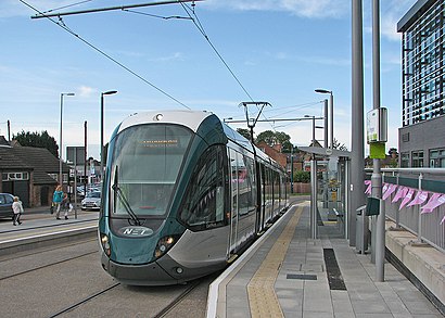
- High Road - Central College Tram Stop, Chilwell,1 min walk,
Bus stations near High Road Central College tram stop in Broxtowe
- Wilmot Lane, Chilwell,2 min walk,
- Georgina Road, Chilwell,7 min walk,
- Church Street, Beeston,9 min walk,
Bus lines to High Road Central College tram stop in Broxtowe
- INDIGO,Long Eaton,
- 18,Nottingham,
- 36,Nottingham,
- 36U,Chilwell,
- SKYLINK NOTTINGHAM,Nottingham,
- 510|NOTTSBUS ECONNECT,Stapleford,
- 18A,Beeston,
- N34,Nottingham,
- 536|NOTTSBUS CONNECT,Chilwell,
What are the nearest stations to High Road Central College tram stop?
The nearest stations to High Road Central College tram stop are:
- High Road - Central College Tram Stop, Chilwell is 7 meters away, 1 min walk.
- Wilmot Lane, Chilwell is 100 meters away, 2 min walk.
- Georgina Road, Chilwell is 489 meters away, 7 min walk.
- Church Street, Beeston is 669 meters away, 9 min walk.
Which bus lines stop near High Road Central College tram stop?
These bus lines stop near High Road Central College tram stop: 36, INDIGO.
Which train line stops near High Road Central College tram stop?
EAST MIDLANDS RAILWAY
Which light rail line stops near High Road Central College tram stop?
TRAM
What’s the nearest light rail station to High Road Central College tram stop in Broxtowe?
The nearest light rail station to High Road Central College tram stop in Broxtowe is High Road - Central College Tram Stop, Chilwell. It’s a 1 min walk away.
What’s the nearest bus stop to High Road Central College tram stop in Broxtowe?
The nearest bus stop to High Road Central College tram stop in Broxtowe is Wilmot Lane, Chilwell. It’s a 2 min walk away.
What time is the first light rail to High Road Central College tram stop in Broxtowe?
The TRAM is the first light rail that goes to High Road Central College tram stop in Broxtowe. It stops nearby at 05:49.
What time is the last light rail to High Road Central College tram stop in Broxtowe?
The TRAM is the last light rail that goes to High Road Central College tram stop in Broxtowe. It stops nearby at 00:14.
What time is the first bus to High Road Central College tram stop in Broxtowe?
The INDIGO is the first bus that goes to High Road Central College tram stop in Broxtowe. It stops nearby at 03:04.
What time is the last bus to High Road Central College tram stop in Broxtowe?
The SKYLINK NOTTINGHAM is the last bus that goes to High Road Central College tram stop in Broxtowe. It stops nearby at 03:41.
See High Road Central College tram stop, Broxtowe, on the map
Public Transit to High Road Central College tram stop in Broxtowe
Wondering how to get to High Road Central College tram stop in Broxtowe, United Kingdom? Moovit helps you find the best way to get to High Road Central College tram stop with step-by-step directions from the nearest public transit station.
Moovit provides free maps and live directions to help you navigate through your city. View schedules, routes, timetables, and find out how long does it take to get to High Road Central College tram stop in real time.
Looking for the nearest stop or station to High Road Central College tram stop? Check out this list of stops closest to your destination: High Road - Central College Tram Stop; Wilmot Lane; Georgina Road; Church Street.
Bus:Train:Light rail:
Want to see if there’s another route that gets you there at an earlier time? Moovit helps you find alternative routes or times. Get directions from and directions to High Road Central College tram stop easily from the Moovit App or Website.
We make riding to High Road Central College tram stop easy, which is why over 1.5 million users, including users in Broxtowe, trust Moovit as the best app for public transit. You don’t need to download an individual bus app or train app, Moovit is your all-in-one transit app that helps you find the best bus time or train time available.
For information on prices of bus, train and light rail, costs and ride fares to High Road Central College tram stop, please check the Moovit app.
Use the app to navigate to popular places including to the airport, hospital, stadium, grocery store, mall, coffee shop, school, college, and university.
Location: Broxtowe, East Midlands
Attractions near High Road Central College tram stop
G H Hurt & Son,Barton Quarter,Chequers Inn Chilwell Beeston,The Berliner,Chilwell Comprehensive School,Caron Keeton Wellness,The Beekeeper (Hungry Horse - Beekeeper Beeston),The Beekeeper ,The Beekeeper,The Royal British Legion Club,Black Line Creative,Beeston Youth & Community Centre,Oliverose Construction Limited,Yellow Wood Cafe,Broxtowe Borough Council,Beeston Library,Went To Mow,Quirkyduck,32 Degrees Limited,Thomas SolicitorsHow to get to popular attractions in Broxtowe with public transportation
Caroline Chisholm School, Northampton,Southwell, Newark And Sherwood,Premier Inn Nottingham West, Broxtowe,Western Park, Leicester,Lenton Boulevard, Nottingham,Mecca Bingo, Broxtowe,Matalan, Corby,Wilko, Nottingham,Holiday Inn Express Peterborough, Peterborough,The Observatory (Wetherspoon), Erewash,Tesco Extra, Leicester,Leicester Royal Infirmary, Leicester,Asda, Rushcliffe,Francis Crick House, Northampton,Kingsway Hospital, Derby,Hucknall Tram Stop, Ashfield,James France Building, Charnwood,Billing Aquadrome, Northampton,Bracebridge Heath, North Kesteven,Market Warsop, MansfieldGet around Broxtowe by public transport!
Travelling around Broxtowe has never been so easy. See step by step directions as you travel to any attraction, street or major public transport station. View bus and train timetables, arrival times, service alerts and detailed routes on a map, so you know exactly how to get to anywhere in Broxtowe.
When travelling to any destination around Broxtowe use Moovit's Live Directions with Get Off Notifications to know exactly where and how far to walk, how long to wait for your line , and how many stops are left. Moovit will alert you when it’s time to get off — no need to constantly re-check whether yours is the next stop.
Wondering how to use public transport in Broxtowe or how to pay for public transport in Broxtowe? Moovit public transport app can help you navigate your way with public transport easily, and at minimum cost. It includes public transport fees, ticket prices, and costs. Looking for a map of Broxtowe public transport lines? Moovit public transport app shows all public transport maps in Broxtowe with all bus, train or light rail routes and stops on an interactive map.
Broxtowe has 3 transport type(s), including: bus, train or light rail, operated by several transport agencies, including National Rail, Ashbourne Community Transport, Delaine Buses, Arriva Midlands, Centrebus, Our Centre, Hulleys of Baslow, D & G Bus, Stagecoach East Midlands, North Lincolnshire Council, National Rail, Roberts Coaches, Lawson's of Corby, Hawkes Coaches and East Yorkshire