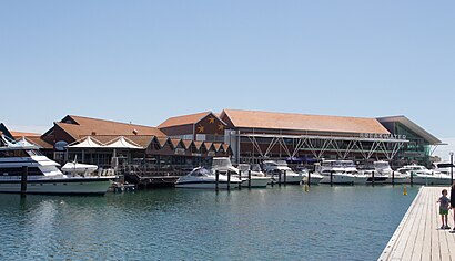
Directions to Hilary Boat Harbour (Perth) with public transport
The following transport lines have routes that pass near Hilary Boat Harbour
How to get to Hilary Boat Harbour by bus?
Click on the bus route to see step by step directions with maps, line arrival times and updated time schedules.
Bus stations near Hilary Boat Harbour in Perth
- West Coast Dr Hillarys Boat Harbour,8 min walk,
Bus lines to Hilary Boat Harbour in Perth
- 423,Hillarys Boat Harbour,
What are the nearest stations to Hilary Boat Harbour?
The nearest stations to Hilary Boat Harbour are:
- West Coast Dr Hillarys Boat Harbour is 604 meters away, 8 min walk.
Which bus lines stop near Hilary Boat Harbour?
These bus lines stop near Hilary Boat Harbour: 423, 441.
What’s the nearest bus stop to Hilary Boat Harbour in Perth?
The nearest bus stop to Hilary Boat Harbour in Perth is West Coast Dr Hillarys Boat Harbour. It’s a 8 min walk away.
See Hilary Boat Harbour, Perth, on the map
Public Transit to Hilary Boat Harbour in Perth
Wondering how to get to Hilary Boat Harbour in Perth, Australia? Moovit helps you find the best way to get to Hilary Boat Harbour with step-by-step directions from the nearest public transit station.
Moovit provides free maps and live directions to help you navigate through your city. View schedules, routes, timetables, and find out how long does it take to get to Hilary Boat Harbour in real time.
Looking for the nearest stop or station to Hilary Boat Harbour? Check out this list of stops closest to your destination: West Coast Dr Hillarys Boat Harbour.
Bus:423441
Want to see if there’s another route that gets you there at an earlier time? Moovit helps you find alternative routes or times. Get directions from and directions to Hilary Boat Harbour easily from the Moovit App or Website.
We make riding to Hilary Boat Harbour easy, which is why over 1.5 million users, including users in Perth, trust Moovit as the best app for public transit. You don’t need to download an individual bus app or train app, Moovit is your all-in-one transit app that helps you find the best bus time or train time available.
For information on prices of bus and train, costs and ride fares to Hilary Boat Harbour, please check the Moovit app.
Use the app to navigate to popular places including to the airport, hospital, stadium, grocery store, mall, coffee shop, school, college, and university.
Location: Perth
Attractions near Hilary Boat Harbour
Hillary Boat Harbour,Sunglass Shack,American Ribs and Grill,The Harbour Terrace Bar & Grill,Scarf Jewellery,Hooligans,Sorrento Beach Shack,Healtheze,Nino's Fish Bar & Cafe,Sweethearts English Candy,R'Nay Clothing,Tygr,Zambrero,Scion Scion,Fro Yo,Over Bored Cafe,Black Swan Cafe,58 Southside Drive,Zing Cafe and Restaurant,Zeno's CafeHow to get to popular attractions in Perth with public transportation
Herb Graham Recreation Centre, Mirrabooka,QEII Medical Centre, Nedlands,Quinns Rocks, Quinns Rocks,Mount Hawthorn, Mount Hawthorn,Albion Hotel, Cottesloe,Grosvenor Hotel, Perth,Fremantle Train Station, Fremantle,Optima Centre, Osborne Park,Ace Cinemas, Rockingham,Bayview Geographe Resort, Broadwater,Penguin Island Ferry, Shoalwater,The Rise At Maylands, Maylands,Balmoral Hotel, East Victoria Park,Coolbellup Shopping Centre, Coolbellup,Sir Charles Gairdner Hospital 8th Floor Cafeteria, Nedlands,Freemantle Esplanade, Fremantle,Westfield Innaloo Shopping Centre, Innaloo,Basinghall Street, East Victoria Park,Good Fortune Roast Duck House, East Victoria Park,Perth Convention Exhibition Centre, PerthGet around Perth by public transport!
Travelling around Perth has never been so easy. See step by step directions as you travel to any attraction, street or major public transport station. View bus and train timetables, arrival times, service alerts and detailed routes on a map, so you know exactly how to get to anywhere in Perth.
When travelling to any destination around Perth use Moovit's Live Directions with Get Off Notifications to know exactly where and how far to walk, how long to wait for your line , and how many stops are left. Moovit will alert you when it’s time to get off — no need to constantly re-check whether yours is the next stop.
Wondering how to use public transport in Perth or how to pay for public transport in Perth? Moovit public transport app can help you navigate your way with public transport easily, and at minimum cost. It includes public transport fees, ticket prices, and costs. Looking for a map of Perth public transport lines? Moovit public transport app shows all public transport maps in Perth with all bus or train routes and stops on an interactive map.
Perth has 2 transport type(s), including: bus or train, operated by several transport agencies, including Transperth Rail, Transwa, Transperth Ferry, Transperth, TransBusselton, TransAlbany, TransGoldfields, TransEsperance, TransGeraldton, TransCarnarvon, TransHedland, TransKarratha, Transwa, TransBunbury and Mandurah Bus Charter