Hillsborough Interchange stop - Sunday schedule
| Line | Direction | Time |
|---|---|---|
| 97 | Totley | 04:50 |
| 52A | Hillsborough | 05:49 |
| 52A | Woodhouse | 05:55 |
| 97 | Totley | 05:55 |
| 52 | Hillsborough | 06:12 |
| 52 | Woodhouse | 06:25 |
| 18A | Sheffield Centre | 06:33 |
| 52A | Hillsborough | 06:49 |
| 52A | Woodhouse | 06:55 |
| 97 | Hillsborough | 07:04 |
| 98 | Totley Brook | 07:09 |
| 52 | Hillsborough | 07:12 |
| 52 | Woodhouse | 07:25 |
| 52A | Hillsborough | 07:49 |
| 52A | Woodhouse | 07:56 |
| 98 | Totley Brook | 08:05 |
| 97 | Hillsborough | 08:09 |
| 52 | Hillsborough | 08:12 |
| 18A | Hillsborough | 08:22 |
| 52 | Woodhouse | 08:25 |
| 97 | Totley | 08:30 |
| 52A | Hillsborough | 08:31 |
| 18A | Sheffield Centre | 08:33 |
| 52A | Woodhouse | 08:40 |
| 52 | Hillsborough | 08:42 |
See Hillsborough Interchange, Sheffield, on the map
Directions to Hillsborough Interchange (Sheffield) with public transport
The following transport lines have routes that pass near Hillsborough Interchange
 Bus:
Bus: - Train:
- Light rail:
How to get to Hillsborough Interchange by bus?
Click on the bus route to see step by step directions with maps, line arrival times and updated time schedules.
How to get to Hillsborough Interchange by train?
Click on the train route to see step by step directions with maps, line arrival times and updated time schedules.
Light Rail stations near Hillsborough Interchange in Sheffield
- Hillsborough (South Yorkshire Supertram), Hillsborough,2 min walk,
- Hillsborough Park,8 min walk,
- Hillsborough,34 min walk,
Bus stations near Hillsborough Interchange in Sheffield
- Langsett Crescent/Freedom Court,2 min walk,
- Walkley Lane/Bowness Road,5 min walk,
- Langsett Road/Ripley Street,7 min walk,
- Penistone Road/Bradfield Road,7 min walk,
- Holme Lane/Walkley Lane,8 min walk,
- Middlewood Road/Taplin Road,8 min walk,
- Middlewood Road/Dykes Hall Road,9 min walk,
Bus lines to Hillsborough Interchange in Sheffield
- 31,Sheffield Centre,
- 52,Hillsborough,
- 52A,Hillsborough,
- 731,Stannington,
- 780,Middlewood,
- 782,Chapeltown,
- 783,Stocksbridge,
- 787,Grenoside,
- 57,Stocksbridge,
- 57A,Sheffield Centre,
- 81,Millhouses,
- 82,Millhouses,
- H1,Fir Vale,
- 7,Woodhouse,
- 8,Sheffield Centre,
- 86,Sheffield Centre,
- 62,Low Bradfield,
- 18,Hillsborough,
- 18A,Sheffield Centre,
- 58,Wharncliffe Side,
What are the nearest stations to Hillsborough Interchange?
The nearest stations to Hillsborough Interchange are:
- Hillsborough (South Yorkshire Supertram), Hillsborough is 94 meters away, 2 min walk.
- Langsett Crescent/Freedom Court is 95 meters away, 2 min walk.
- Walkley Lane/Bowness Road is 312 meters away, 5 min walk.
- Langsett Road/Ripley Street is 481 meters away, 7 min walk.
- Penistone Road/Bradfield Road is 531 meters away, 7 min walk.
- Holme Lane/Walkley Lane is 551 meters away, 8 min walk.
- Hillsborough Park is 565 meters away, 8 min walk.
- Middlewood Road/Taplin Road is 607 meters away, 8 min walk.
- Middlewood Road/Dykes Hall Road is 625 meters away, 9 min walk.
- Hillsborough is 2650 meters away, 34 min walk.
Which bus lines stop near Hillsborough Interchange?
These bus lines stop near Hillsborough Interchange: 57, 57A, 81, 82, 97.
Which train line stops near Hillsborough Interchange?
NORTHERN
Which light rail lines stop near Hillsborough Interchange?
These light rail lines stop near Hillsborough Interchange: BLUE, YELL.
What’s the nearest light rail station to Hillsborough Interchange in Sheffield?
The nearest light rail station to Hillsborough Interchange in Sheffield is Hillsborough (South Yorkshire Supertram), Hillsborough. It’s a 2 min walk away.
What’s the nearest bus stop to Hillsborough Interchange in Sheffield?
The nearest bus stop to Hillsborough Interchange in Sheffield is Langsett Crescent/Freedom Court. It’s a 2 min walk away.
What time is the first light rail to Hillsborough Interchange in Sheffield?
The BLUE is the first light rail that goes to Hillsborough Interchange in Sheffield. It stops nearby at 05:37.
What time is the last light rail to Hillsborough Interchange in Sheffield?
The BLUE is the last light rail that goes to Hillsborough Interchange in Sheffield. It stops nearby at 00:23.
What time is the first bus to Hillsborough Interchange in Sheffield?
The 7 is the first bus that goes to Hillsborough Interchange in Sheffield. It stops nearby at 04:37.
What time is the last bus to Hillsborough Interchange in Sheffield?
The 18A is the last bus that goes to Hillsborough Interchange in Sheffield. It stops nearby at 00:44.
How much is the train fare to Hillsborough Interchange?
The train fare to Hillsborough Interchange costs about £3.20 - £13.10.
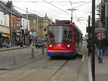
Hillsborough Interchange station
 Taken by Isaac
See Hillsborough Interchange, Sheffield, on the map
Public transport to Hillsborough Interchange stop in Sheffield
Looking for directions to Hillsborough Interchange in Sheffield, United Kingdom?
Download the Moovit App to find the current schedule and step-by-step directions for Bus, Light rail or Train routes that pass through Hillsborough Interchange.
Looking for the nearest stops closest to Hillsborough Interchange ? Check out this list of closest stops to your destination: Hillsborough (South Yorkshire Supertram); Langsett Crescent/Freedom Court; Walkley Lane/Bowness Road; Langsett Road/Ripley Street; Penistone Road/Bradfield Road; Holme Lane/Walkley Lane; Hillsborough Park; Middlewood Road/Taplin Road; Middlewood Road/Dykes Hall Road; Hillsborough.
Bus:Train:Light rail:
We make riding on public transit to Hillsborough Interchange easy, which is why over 1.5 million users, including users in Sheffield trust Moovit as the best app for public transit.
Use the app to navigate to popular places including to the airport, hospital, stadium, grocery store, mall, coffee shop, school, college, and university.
The first line to this stop is 97, at 04:50, and the last line is 18A at 00:16.
Kipling Road, Sheffield, England, United Kingdom
This stop serves Stagecoach Yorkshire, First South Yorkshire, South Pennine Community Transport and TM Travel’s lines
Popular routes from Hillsborough Interchange, Sheffield
Light Rail stations near Hillsborough Interchange
Hillsborough (South Yorkshire Supertram), Hillsborough,Hillsborough Park,HillsboroughBus stops near Hillsborough Interchange
Langsett Crescent/Freedom Court,Walkley Lane/Bowness Road,Langsett Road/Ripley Street,Penistone Road/Bradfield Road,Holme Lane/Walkley Lane,Middlewood Road/Taplin Road,Middlewood Road/Dykes Hall RoadPopular public transport stations in Sheffield
Handsworth Road/Finchwell Road,Howden,Fairfield Avenue,Bond Street E,West Bar/Workhouse Lane,Headrow E,Longley Lane/Herries Road,Spital Hill/Spital Street,St James's Hospital,Highlands Health Centre,White Lee Road,Victoria Avenue,Kirkstall Bridge SP,Chain Lane,Wincobank Avenue/Bluebell Road,Mytholmroyd,Ringinglow Road/Sheephill Road,West Hill/Hill Top Lane,Green Lane,Waterthorpe Greenway/Peaks MountGet around Sheffield by public transport!
Travelling around Sheffield has never been so easy. See step by step directions as you travel to any attraction, street or major public transport station. View bus and train timetables, arrival times, service alerts and detailed routes on a map, so you know exactly how to get to anywhere in Sheffield.
When travelling to any destination around Sheffield use Moovit's Live Directions with Get Off Notifications to know exactly where and how far to walk, how long to wait for your line , and how many stops are left. Moovit will alert you when it’s time to get off — no need to constantly re-check whether yours is the next stop.
Wondering how to use public transport in Sheffield or how to pay for public transport in Sheffield? Moovit public transport app can help you navigate your way with public transport easily, and at minimum cost. It includes public transport fees, ticket prices, and costs. Looking for a map of Sheffield public transport lines? Moovit public transport app shows all public transport maps in Sheffield with all bus, light rail or train routes and stops on an interactive map.
Sheffield has 3 transport type(s), including: bus, light rail or train, operated by several transport agencies, including First Leeds, First South Yorkshire, First York, First West Yorkshire Ltd, Arriva Yorkshire, Stagecoach Yorkshire, National Rail, First Bradford, First Halifax, Calder Valley & Huddersfield, East Yorkshire, The Keighley Bus Company, South Yorkshire Future Tram, The Harrogate Bus Company, National Rail and TM Travel