Directions to Holborn Station (Bloomsbury) with public transport
The following transport lines have routes that pass near Holborn Station
How to get to Holborn Station by bus?
Click on the bus route to see step by step directions with maps, line arrival times and updated time schedules.
How to get to Holborn Station by train?
Click on the train route to see step by step directions with maps, line arrival times and updated time schedules.
How to get to Holborn Station by Tube?
Click on the Tube route to see step by step directions with maps, line arrival times and updated time schedules.
Bus stations near Holborn Station in Bloomsbury
- Procter Street (H), 2 min walk,
- Red Lion Square (J), 3 min walk,
- Kingsway / Holborn Station (M), 3 min walk,
- High Holborn (Q), 3 min walk,
- Bloomsbury Square (B), 4 min walk,
Tube stations near Holborn Station in Bloomsbury
- Holborn, 2 min walk,
- Temple, 10 min walk,
Bus lines to Holborn Station in Bloomsbury
- 8, Tottenham Court Road - Bow Church,
- N8, Oxford Circus - Hainault, The Lowe,
- N25, Ilford - Oxford Circus,
- 59, Smithfield, St Bartholomew's Hospital - Streatham Hill, Telford Avenue,
- 133, Holborn - Streatham Station,
- N242, Tottenham Court Road - Homerton Hospital,
- 98, Holborn - Willesden, Bus Garage,
- N98, Holborn - Stanmore Station,
- 1, Canada Water,
- N1, Thamesmead,
- SL6, West Croydon,
- 68, Euston,
- N68, Tottenham Court Road,
- 91, Crouch End,
- N91, Trafalgar Square,
- N171, Hither Green Station,
- 188, North Greenwich,
- 243, Waterloo,
- N207, Holborn,
- 19, Battersea Bridge, South Side - Finsbury Park Station,
What are the nearest stations to Holborn Station?
The nearest stations to Holborn Station are:
- Procter Street (H) is 87 meters away, 2 min walk.
- Holborn is 110 meters away, 2 min walk.
- Red Lion Square (J) is 168 meters away, 3 min walk.
- Kingsway / Holborn Station (M) is 176 meters away, 3 min walk.
- High Holborn (Q) is 210 meters away, 3 min walk.
- Bloomsbury Square (B) is 283 meters away, 4 min walk.
- Temple is 762 meters away, 10 min walk.
Which bus lines stop near Holborn Station?
These bus lines stop near Holborn Station: 14, 243, 55, 59, 91, 98.
Which train lines stop near Holborn Station?
These train lines stop near Holborn Station: ELIZABETH, SOUTH WESTERN RAILWAY, SOUTHEASTERN, WEST MIDLANDS RAILWAY.
Which Tube lines stop near Holborn Station?
These Tube lines stop near Holborn Station: CENTRAL, PICCADILLY.
What’s the nearest Tube station to Holborn Station in Bloomsbury?
The nearest Tube station to Holborn Station in Bloomsbury is Holborn. It’s a 2 min walk away.
What’s the nearest bus stop to Holborn Station in Bloomsbury?
The nearest bus stop to Holborn Station in Bloomsbury is Procter Street (H). It’s a 2 min walk away.
What time is the first Tube to Holborn Station in Bloomsbury?
The PICCADILLY is the first Tube that goes to Holborn Station in Bloomsbury. It stops nearby at 03:32.
What time is the last Tube to Holborn Station in Bloomsbury?
The DISTRICT is the last Tube that goes to Holborn Station in Bloomsbury. It stops nearby at 00:41.
What time is the first bus to Holborn Station in Bloomsbury?
The N98 is the first bus that goes to Holborn Station in Bloomsbury. It stops nearby at 03:00.
What time is the last bus to Holborn Station in Bloomsbury?
The N8 is the last bus that goes to Holborn Station in Bloomsbury. It stops nearby at 04:09.
See Holborn Station, Bloomsbury, on the map
Public Transit to Holborn Station in Bloomsbury
Wondering how to get to Holborn Station in Bloomsbury, United Kingdom? Moovit helps you find the best way to get to Holborn Station with step-by-step directions from the nearest public transit station.
Moovit provides free maps and live directions to help you navigate through your city. View schedules, routes, timetables, and find out how long does it take to get to Holborn Station in real time.
Looking for the nearest stop or station to Holborn Station? Check out this list of stops closest to your destination: Procter Street (H); Holborn; Red Lion Square (J); Kingsway / Holborn Station (M); High Holborn (Q); Bloomsbury Square (B); Temple.
Bus: 14, 243, 55, 59, 91, 98, 8, N8, N25, 133, N98, 1, N1, SL6, 68, N68, N207.Train: ELIZABETH, SOUTH WESTERN RAILWAY, SOUTHEASTERN, WEST MIDLANDS RAILWAY.Tube: CENTRAL, PICCADILLY, CIRCLE, DISTRICT.
Want to see if there’s another route that gets you there at an earlier time? Moovit helps you find alternative routes or times. Get directions from and directions to Holborn Station easily from the Moovit App or Website.
We make riding to Holborn Station easy, which is why over 1.5 million users, including users in Bloomsbury, trust Moovit as the best app for public transit. You don’t need to download an individual bus app or train app, Moovit is your all-in-one transit app that helps you find the best bus time or train time available.
For information on prices of Tube, bus and train, costs and ride fares to Holborn Station, please check the Moovit app.
Use the app to navigate to popular places including to the airport, hospital, stadium, grocery store, mall, coffee shop, school, college, and university.
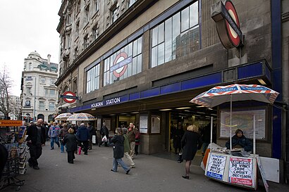
Holborn Station Address: High Holborn street in Bloomsbury
Attractions near Holborn Station
Waitrose,94-99 High Holborn,Holborn - Central Line - Westbound - Platform 1,Citadines Holborn Covent Garden Hotel,The London Skin and Hair Clinic,The Ship Tavern,Rosewood London,Holborn Dining Room,Holborn House,Skipton Building Society,Kingsway Holborn Station (Stop M) (Underground-Holborn),Leeds Building Society,Sir John Soane's Museum,Holborn Underground Station,Mishcon de Reya,Holborn London Underground Station,The Square Pig,Crossrail Fisher Street Shaft,Kingsway Holborn Station (Stop M),EatalyHow to get to popular attractions in Bloomsbury with public transportation
Lewisham Shopping Centre, Lewisham,Kingston upon Thames, Kingston,Terminal 4, Heathrow,Nuffield Health, Hayes Town,The Shard, Borough,Bicester North Railway Station (BCS), Bicester,Westfield Stratford City, Stratford,Hillingdon Hospital, Hillingdon,Homerton University Hospital, Clapton,Queen Elizabeth Hospital, Woolwich,North Finchley, Finchley,Queens Hospital, Romford,Terminal 3, Heathrow,Brent Cross Shopping Centre, Brent Cross,Southall, Southall,Science Museum, Kensington,Departure Lounge, Stansted,Ilford, Ilford,Cineworld, Chichester (Town),Oxford Circus, SohoGet around London by public transport!
Travelling around London has never been so easy. See step by step directions as you travel to any attraction, street or major public transport station. View bus and train timetables, arrival times, service alerts and detailed routes on a map, so you know exactly how to get to anywhere in London.
When travelling to any destination around London use Moovit's Live Directions with Get Off Notifications to know exactly where and how far to walk, how long to wait for your line , and how many stops are left. Moovit will alert you when it’s time to get off — no need to constantly re-check whether yours is the next stop.
Wondering how to use public transport in London or how to pay for public transport in London? Moovit public transport app can help you navigate your way with public transport easily, and at minimum cost. It includes public transport fees, ticket prices, and costs. Looking for a map of London public transport lines? Moovit public transport app shows all public transport maps in London with all Bus, Train, Tube, Tramlink, River Bus and DLR routes and stops on an interactive map.
London has 6 transport type(s), including: Bus, Train, Tube, Tramlink, River Bus and DLR, operated by several transport agencies, including London Underground, London Buses, Transport for London, London Tramlink, National Rail, Bluestar, Berry's Coaches, Oxford Bus Company, Stagecoach West, Community First Wessex, Cresta Coaches, D & P Boat Hire, First Portsmouth, Fareham & Gosport, FYTbus, IFS Cloud Cable Car