Directions to Hollingbourne Station (Maidstone) with public transport
The following transport lines have routes that pass near Hollingbourne Station
How to get to Hollingbourne Station by bus?
Click on the bus route to see step by step directions with maps, line arrival times and updated time schedules.
How to get to Hollingbourne Station by train?
Click on the train route to see step by step directions with maps, line arrival times and updated time schedules.
Bus stations near Hollingbourne Station in Maidstone
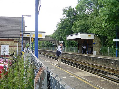
- Hollingbourne,1 min walk,
- Village Shop, Eyhorne Street,7 min walk,
- Great Danes Hotel, Hollingbourne,15 min walk,
Bus lines to Hollingbourne Station in Maidstone
- SOUTHEASTERN,Ramsgate,
- SOUTHEASTERN,Bus Replacement: Ashford International,
- 13,Hollingbourne,
- 14,Hollingbourne,
- 10X,Ashford,
What are the nearest stations to Hollingbourne Station?
The nearest stations to Hollingbourne Station are:
- Hollingbourne is 30 meters away, 1 min walk.
- Village Shop, Eyhorne Street is 493 meters away, 7 min walk.
- Great Danes Hotel, Hollingbourne is 1163 meters away, 15 min walk.
Which bus lines stop near Hollingbourne Station?
These bus lines stop near Hollingbourne Station: 10X, 13.
Which train line stops near Hollingbourne Station?
SOUTHEASTERN
What’s the nearest bus stop to Hollingbourne Station in Maidstone?
The nearest bus stop to Hollingbourne Station in Maidstone is Hollingbourne. It’s a 1 min walk away.
What time is the first train to Hollingbourne Station in Maidstone?
The SOUTHEASTERN is the first train that goes to Hollingbourne Station in Maidstone. It stops nearby at 05:49.
What time is the last train to Hollingbourne Station in Maidstone?
The SOUTHEASTERN is the last train that goes to Hollingbourne Station in Maidstone. It stops nearby at 00:39.
What time is the first bus to Hollingbourne Station in Maidstone?
The 10X is the first bus that goes to Hollingbourne Station in Maidstone. It stops nearby at 06:31.
What time is the last bus to Hollingbourne Station in Maidstone?
The 10X is the last bus that goes to Hollingbourne Station in Maidstone. It stops nearby at 19:35.
See Hollingbourne Station, Maidstone, on the map
Public Transit to Hollingbourne Station in Maidstone
Wondering how to get to Hollingbourne Station in Maidstone, United Kingdom? Moovit helps you find the best way to get to Hollingbourne Station with step-by-step directions from the nearest public transit station.
Moovit provides free maps and live directions to help you navigate through your city. View schedules, routes, timetables, and find out how long does it take to get to Hollingbourne Station in real time.
Looking for the nearest stop or station to Hollingbourne Station? Check out this list of stops closest to your destination: Hollingbourne; Village Shop; Great Danes Hotel.
Bus:10X13SOUTHEASTERNSOUTHEASTERN14Train:SOUTHEASTERN
Want to see if there’s another route that gets you there at an earlier time? Moovit helps you find alternative routes or times. Get directions from and directions to Hollingbourne Station easily from the Moovit App or Website.
We make riding to Hollingbourne Station easy, which is why over 1.5 million users, including users in Maidstone, trust Moovit as the best app for public transit. You don’t need to download an individual bus app or train app, Moovit is your all-in-one transit app that helps you find the best bus time or train time available.
For information on prices of bus and train, costs and ride fares to Hollingbourne Station, please check the Moovit app.
Use the app to navigate to popular places including to the airport, hospital, stadium, grocery store, mall, coffee shop, school, college, and university.
Hollingbourne Station Address: Hollingbourne Maidstone street in Maidstone
Attractions near Hollingbourne Station
Hollingbourne (Millennium Green),The Windmill, Hollingbourne,M20 Junction 8,Roadchef Maidstone Services,Pop-Ins Pet Care Services,Mercure Maidstone,Great Danes Hotel,Hollingbourne,Maidstone Motorway Services (RoadChef),Maidstone services,Me17 1re,Mercure Maidstone Great Danes,Leeds Castle,Go Ape Leeds Castle,Me17 1rg,The Park Gate Inn Restaurant,Bearsted Caravan And Motorhome Club Site,Royaume-Uni,Leeds Castle,Paul & StephHow to get to popular attractions in Maidstone with public transportation
Costco Wholesale, South Croydon,Amazon.co.uk HQ, Slough,Stratford Centre, Stratford,Brent Cross Shopping Centre, Brent Cross,Whitgift School, South Croydon,Virgin Active Chelsea, Chelsea,Cricklewood, Cricklewood,Renaissance London Heathrow Hotel, Heathrow,Hayes Railway Station, Hayes (Kent),Heathrow Terminal 3, Heathrow,Ferney Road, East Barnet,Terminal 4, Heathrow,Romford Market, Romford,Kingston University Penrhyn Road Campus, Kingston,British Museum, Bloomsbury,Brentwood, Brentwood,Southgate, Southgate,Gatwick Airport, Crawley,The Shard, Borough,Oxford Brookes University Gipsy Lane Site, OxfordGet around Maidstone by public transport!
Travelling around Maidstone has never been so easy. See step by step directions as you travel to any attraction, street or major public transport station. View bus and train timetables, arrival times, service alerts and detailed routes on a map, so you know exactly how to get to anywhere in Maidstone.
When travelling to any destination around Maidstone use Moovit's Live Directions with Get Off Notifications to know exactly where and how far to walk, how long to wait for your line , and how many stops are left. Moovit will alert you when it’s time to get off — no need to constantly re-check whether yours is the next stop.
Wondering how to use public transport in Maidstone or how to pay for public transport in Maidstone? Moovit public transport app can help you navigate your way with public transport easily, and at minimum cost. It includes public transport fees, ticket prices, and costs. Looking for a map of Maidstone public transport lines? Moovit public transport app shows all public transport maps in Maidstone with all bus or train routes and stops on an interactive map.
Maidstone has 2 transport type(s), including: bus or train, operated by several transport agencies, including London Underground, London Buses, Transport for London, London Tramlink, Transport for London, National Rail, Bluestar, Berry's Coaches, Oxford Bus Company, Stagecoach West, Community First Wessex, Cresta Coaches, D & P Boat Hire, First Portsmouth, Fareham & Gosport and FYTbus