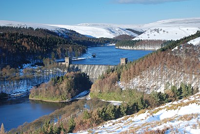
See Howden Reservoir, High Peak, on the map
Directions to Howden Reservoir (High Peak) with public transport
The following transport lines have routes that pass near Howden Reservoir
 Bus:
Bus:
How to get to Howden Reservoir by bus?
Click on the bus route to see step by step directions with maps, line arrival times and updated time schedules.
Which bus line stops near Howden Reservoir?
273
See Howden Reservoir, High Peak, on the map
Public Transit to Howden Reservoir in High Peak
Wondering how to get to Howden Reservoir in High Peak, United Kingdom? Moovit helps you find the best way to get to Howden Reservoir with step-by-step directions from the nearest public transit station.
Moovit provides free maps and live directions to help you navigate through your city. View schedules, routes, timetables, and find out how long does it take to get to Howden Reservoir in real time.
Bus:
Want to see if there’s another route that gets you there at an earlier time? Moovit helps you find alternative routes or times. Get directions from and directions to Howden Reservoir easily from the Moovit App or Website.
We make riding to Howden Reservoir easy, which is why over 1.5 million users, including users in High Peak, trust Moovit as the best app for public transit. You don’t need to download an individual bus app or train app, Moovit is your all-in-one transit app that helps you find the best bus time or train time available.
For information on prices of bus and light rail, costs and ride fares to Howden Reservoir, please check the Moovit app.
Use the app to navigate to popular places including to the airport, hospital, stadium, grocery store, mall, coffee shop, school, college, and university.
Location: High Peak, Yorkshire
Attractions near Howden Reservoir
Howden Farm,Bosen Holes,Cow Hey,Hey Bank,Abbey Grange,Stony Bank Clough,Hindholes Clough,Howden Clough,Abbey Bank,Cold Side,Cold Side Oaks,Long Edge,Cold Side Clough,Bamford House,Shire Owler's,Upper Hey,Walker's Farm,Walker's Clough,Howden Edge,Derwent ReservoirHow to get to popular attractions in High Peak with public transportation
Princes Quay Shopping Centre, Hull,Hunter's Bar, Sheffield,Robin Hood Airport (DSA), Finningley,Sainsbury's Leeds Colton, Leeds,Sumo Digital, Sheffield,Asos, Little Houghton,The Cuthbert Broderick (Wetherspoon), Leeds,York College, York,Scarborough, Scarborough,Cardigan Fields Leisure Park, Leeds,Supertram - Yellow Route: Meadowhall via City Centre to Middlewood, Sheffield,Brighouse Bus Station, Halifax,PwC Leeds, Leeds,Graves Park, Sheffield,Dewsbury & District Hospital, Heckmondwike,Greenhead College, Huddersfield,Cleckheaton, Heckmondwike,Elland Road Stadium, Leeds,Becketts Bank (Wetherspoon), Leeds,Middlewood Tram Stop, SheffieldGet around High Peak by public transport!
Travelling around High Peak has never been so easy. See step by step directions as you travel to any attraction, street or major public transport station. View bus and train timetables, arrival times, service alerts and detailed routes on a map, so you know exactly how to get to anywhere in High Peak.
When travelling to any destination around High Peak use Moovit's Live Directions with Get Off Notifications to know exactly where and how far to walk, how long to wait for your line , and how many stops are left. Moovit will alert you when it’s time to get off — no need to constantly re-check whether yours is the next stop.
Wondering how to use public transport in High Peak or how to pay for public transport in High Peak? Moovit public transport app can help you navigate your way with public transport easily, and at minimum cost. It includes public transport fees, ticket prices, and costs. Looking for a map of High Peak public transport lines? Moovit public transport app shows all public transport maps in High Peak with all bus or light rail routes and stops on an interactive map.
High Peak has 2 transport type(s), including: bus or light rail, operated by several transport agencies, including First Leeds, First South Yorkshire, First York, First West Yorkshire Ltd, Arriva Yorkshire, Stagecoach Yorkshire, National Rail, First Bradford, First Halifax, Calder Valley & Huddersfield, East Yorkshire, The Keighley Bus Company, South Yorkshire Future Tram, The Harrogate Bus Company, National Rail and TM Travel