Directions to Kidderminster Hospital (Blakebrook & Habberley South) with public transport
The following transport lines have routes that pass near Kidderminster Hospital
How to get to Kidderminster Hospital by bus?
Click on the bus route to see step by step directions with maps, line arrival times and updated time schedules.
How to get to Kidderminster Hospital by train?
Click on the train route to see step by step directions with maps, line arrival times and updated time schedules.
Bus stops near Kidderminster Hospital in Blakebrook & Habberley South
- Proud Cross Ringway, 3 min walk,
- General Hospital, 6 min walk,
- Police Station, 7 min walk,
Train station near Kidderminster Hospital in Blakebrook & Habberley South
- Kidderminster, 25 min walk,
Bus lines to Kidderminster Hospital in Blakebrook & Habberley South
- 4, Blakebrook & Habberley South - Franche & Habberley North,
- 4A, Franche & Habberley North,
- 297, Bridgnorth East And Astley Abbotts Ed - Blakebrook & Habberley South,
- 829, Wyre Forest Rural - Blakebrook & Habberley South,
- 291, Regal,
- 292, Kidderminster Bus Station,
- 292S, Cleobury Mortimer,
- 302, Hales Park, Hop Pole Inn,
- 125, Bridgnorth, Sainsburys Superstore,
What are the nearest stations to Kidderminster Hospital?
The nearest stations to Kidderminster Hospital are:
- Proud Cross Ringway is 189 meters away, 3 min walk.
- General Hospital is 449 meters away, 6 min walk.
- Police Station is 489 meters away, 7 min walk.
- Kidderminster is 1878 meters away, 25 min walk.
Which bus line stops near Kidderminster Hospital?
52 (Kidderminster Bus Station)
Which train line stops near Kidderminster Hospital?
WEST MIDLANDS RAILWAY (Worcester Foregate Street)
What’s the nearest train station to Kidderminster Hospital in Blakebrook & Habberley South?
The nearest train station to Kidderminster Hospital in Blakebrook & Habberley South is Kidderminster. It’s a 25 min walk away.
What’s the nearest bus station to Kidderminster Hospital in Blakebrook & Habberley South?
The nearest bus station to Kidderminster Hospital in Blakebrook & Habberley South is Proud Cross Ringway. It’s a 3 min walk away.
What time is the first train to Kidderminster Hospital in Blakebrook & Habberley South?
The WEST MIDLANDS RAILWAY is the first train that goes to Kidderminster Hospital in Blakebrook & Habberley South. It stops nearby at 09:46.
What time is the last train to Kidderminster Hospital in Blakebrook & Habberley South?
The WEST MIDLANDS RAILWAY is the last train that goes to Kidderminster Hospital in Blakebrook & Habberley South. It stops nearby at 23:31.
What time is the first bus to Kidderminster Hospital in Blakebrook & Habberley South?
The 3 is the first bus that goes to Kidderminster Hospital in Blakebrook & Habberley South. It stops nearby at 09:10.
What time is the last bus to Kidderminster Hospital in Blakebrook & Habberley South?
The 3 is the last bus that goes to Kidderminster Hospital in Blakebrook & Habberley South. It stops nearby at 18:01.
See Kidderminster Hospital, Blakebrook & Habberley South, on the map
Public Transit to Kidderminster Hospital in Blakebrook & Habberley South
Wondering how to get to Kidderminster Hospital in Blakebrook & Habberley South, United Kingdom? Moovit helps you find the best way to get to Kidderminster Hospital with step-by-step directions from the nearest public transit station.
Moovit provides free maps and live directions to help you navigate through your city. View schedules, routes, timetables, and find out how long does it take to get to Kidderminster Hospital in real time.
Looking for the nearest stop or station to Kidderminster Hospital? Check out this list of stops closest to your destination: Proud Cross Ringway; General Hospital; Police Station; Kidderminster.
Bus: 52, 4, 4A, 297, 829, 291, 292, 292S, 302, 125.Train: WEST MIDLANDS RAILWAY.
Want to see if there’s another route that gets you there at an earlier time? Moovit helps you find alternative routes or times. Get directions from and directions to Kidderminster Hospital easily from the Moovit App or Website.
We make riding to Kidderminster Hospital easy, which is why over 1.5 million users, including users in Blakebrook & Habberley South, trust Moovit as the best app for public transit. You don’t need to download an individual bus app or train app, Moovit is your all-in-one transit app that helps you find the best bus time or train time available.
For information on prices of train and bus, costs and ride fares to Kidderminster Hospital, please check the Moovit app.
Use the app to navigate to popular places including to the airport, hospital, stadium, grocery store, mall, coffee shop, school, college, and university.
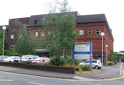
Kidderminster Hospital Address: Sutton Road street in Blakebrook & Habberley South
Kidderminster Hospital is an acute general hospital in Kidderminster in Worcestershire, England. It is managed by the Worcestershire Acute Hospitals NHS Trust.Wiki
Popular routes to Kidderminster Hospital, Blakebrook & Habberley South
Places Near Kidderminster Hospital (Blakebrook & Habberley South)
How to get to popular places in West Midlands with public transport
Get around Blakebrook & Habberley South by public transport!
Travelling around Blakebrook & Habberley South has never been so easy. See step by step directions as you travel to any attraction, street or major public transport station. View bus and train timetables, arrival times, service alerts and detailed routes on a map, so you know exactly how to get to anywhere in Blakebrook & Habberley South.
When travelling to any destination around Blakebrook & Habberley South use Moovit's Live Directions with Get Off Notifications to know exactly where and how far to walk, how long to wait for your line , and how many stops are left. Moovit will alert you when it’s time to get off — no need to constantly re-check whether yours is the next stop.
Wondering how to use public transport in Blakebrook & Habberley South or how to pay for public transport in Blakebrook & Habberley South? Moovit public transport app can help you navigate your way with public transport easily, and at minimum cost. It includes public transport fees, ticket prices, and costs. Looking for a map of Blakebrook & Habberley South public transport lines? Moovit public transport app shows all public transport maps in Blakebrook & Habberley South with all Bus, Train and Light rail routes and stops on an interactive map.
West Midlands has 3 transport type(s), including: Bus, Train and Light rail, operated by several transport agencies, including National Express West Midlands, National Express Coventry, National Express, Diamond Bus, Arriva Midlands, Stagecoach Midlands, West Midlands Metro, Stagecoach West, Stagecoach South Wales, First Potteries, First Worcestershire, LandFlight, trentbarton, D & G Bus and Flexibus