Directions to Knightswood St Margaret's Parish Church (Glasgow) with public transport
The following transport lines have routes that pass near Knightswood St Margaret's Parish Church
How to get to Knightswood St Margaret's Parish Church by bus?
Click on the bus route to see step by step directions with maps, line arrival times and updated time schedules.
How to get to Knightswood St Margaret's Parish Church by train?
Click on the train route to see step by step directions with maps, line arrival times and updated time schedules.
Bus stations near Knightswood St Margaret's Parish Church in Glasgow
- St Ninians Church, Knightswood,3 min walk,
- Morion Road, Knightswood,3 min walk,
- Knightswood Cross, Knightswood,3 min walk,
- Locksley Avenue, Knightswood,6 min walk,
Train stations near Knightswood St Margaret's Parish Church in Glasgow
- Kelvindale,29 min walk,
Ferry stations near Knightswood St Margaret's Parish Church in Glasgow
- Yoker Ferry Terminal, Yoker,55 min walk,
Bus lines to Knightswood St Margaret's Parish Church in Glasgow
- X4,Glasgow,
- 94,Knightswood,
- 6A,Drumchapel,
- N6,Glasgow,
- N60,Anniesland,
- 11,Clydebank,
- M11,Kelvinside,
- 3,Cardonald,
What are the nearest stations to Knightswood St Margaret's Parish Church?
The nearest stations to Knightswood St Margaret's Parish Church are:
- St Ninians Church, Knightswood is 134 meters away, 3 min walk.
- Morion Road, Knightswood is 147 meters away, 3 min walk.
- Knightswood Cross, Knightswood is 158 meters away, 3 min walk.
- Locksley Avenue, Knightswood is 391 meters away, 6 min walk.
- Kelvindale is 2268 meters away, 29 min walk.
- Yoker Ferry Terminal, Yoker is 4276 meters away, 55 min walk.
Which bus lines stop near Knightswood St Margaret's Parish Church?
These bus lines stop near Knightswood St Margaret's Parish Church: 11, 6, 6A, X4.
Which train line stops near Knightswood St Margaret's Parish Church?
SCOTRAIL
What’s the nearest train station to Knightswood St Margaret's Parish Church in Glasgow?
The nearest train station to Knightswood St Margaret's Parish Church in Glasgow is Kelvindale. It’s a 29 min walk away.
What’s the nearest bus stop to Knightswood St Margaret's Parish Church in Glasgow?
The nearest bus stops to Knightswood St Margaret's Parish Church in Glasgow are St Ninians Church, Knightswood, Morion Road, Knightswood and Knightswood Cross, Knightswood. The closest one is a 3 min walk away.
What time is the first train to Knightswood St Margaret's Parish Church in Glasgow?
The SCOTRAIL is the first train that goes to Knightswood St Margaret's Parish Church in Glasgow. It stops nearby at 09:48.
What time is the last train to Knightswood St Margaret's Parish Church in Glasgow?
The SCOTRAIL is the last train that goes to Knightswood St Margaret's Parish Church in Glasgow. It stops nearby at 19:16.
What time is the first bus to Knightswood St Margaret's Parish Church in Glasgow?
The 3 is the first bus that goes to Knightswood St Margaret's Parish Church in Glasgow. It stops nearby at 04:46.
What time is the last bus to Knightswood St Margaret's Parish Church in Glasgow?
The 3 is the last bus that goes to Knightswood St Margaret's Parish Church in Glasgow. It stops nearby at 00:12.
What time is the first ferry to Knightswood St Margaret's Parish Church in Glasgow?
The CLK is the first ferry that goes to Knightswood St Margaret's Parish Church in Glasgow. It stops nearby at 10:05.
What time is the last ferry to Knightswood St Margaret's Parish Church in Glasgow?
The CLK is the last ferry that goes to Knightswood St Margaret's Parish Church in Glasgow. It stops nearby at 18:35.
See Knightswood St Margaret's Parish Church, Glasgow, on the map
Public Transit to Knightswood St Margaret's Parish Church in Glasgow
Wondering how to get to Knightswood St Margaret's Parish Church in Glasgow, United Kingdom? Moovit helps you find the best way to get to Knightswood St Margaret's Parish Church with step-by-step directions from the nearest public transit station.
Moovit provides free maps and live directions to help you navigate through your city. View schedules, routes, timetables, and find out how long does it take to get to Knightswood St Margaret's Parish Church in real time.
Looking for the nearest stop or station to Knightswood St Margaret's Parish Church? Check out this list of stops closest to your destination: St Ninians Church; Morion Road; Knightswood Cross; Locksley Avenue; Kelvindale; Yoker Ferry Terminal.
Bus:1166AX494N6N60M113Train:SCOTRAILFerry:CLK
Want to see if there’s another route that gets you there at an earlier time? Moovit helps you find alternative routes or times. Get directions from and directions to Knightswood St Margaret's Parish Church easily from the Moovit App or Website.
We make riding to Knightswood St Margaret's Parish Church easy, which is why over 1.5 million users, including users in Glasgow, trust Moovit as the best app for public transit. You don’t need to download an individual bus app or train app, Moovit is your all-in-one transit app that helps you find the best bus time or train time available.
For information on prices of bus and train, costs and ride fares to Knightswood St Margaret's Parish Church, please check the Moovit app.
Use the app to navigate to popular places including to the airport, hospital, stadium, grocery store, mall, coffee shop, school, college, and university.
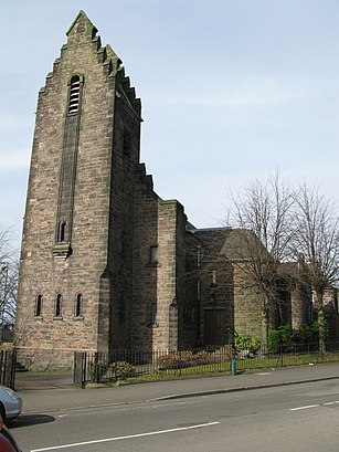
Knightswood St Margaret's Parish Church Address: Great Western Road street in Glasgow
Knightswood St. Margaret's Parish Church is a parish church of the Church of Scotland, serving part of the Knightswood area of Glasgow, Scotland.Wiki
Attractions near Knightswood St Margaret's Parish Church
Knightswood St Margaret's Parish Church,Knightswood St Margaret s Parish Church,St Margarets Church Knightswood Cross,Mohsan Bros,Papa Ali,Food Xpress,Technik,St Ninian's Roman Catholic Church,Notemachine,Knightscliffe Temple Community Credit Union,Post Office,Knightswood Gifts,Bank of Ireland,Knights Barbers,Steven Sim & Son,Stravaigin,Stravaigin Scotland,Baldwin Avenue Knightswood,Knightswood Cross,Blushing BridesHow to get to popular attractions in Glasgow with public transportation
IKEA, Glasgow,Corstorphine, Edinburgh,Glasgow Green, Glasgow,Dalry, Edinburgh,Kirkcaldy Bus Station, Kirkcaldy And Dysart,England / Scotland Border, Carlisle District (B),John Lewis, Glasgow,Crossmyloof Railway Station (CMY), Glasgow,Glasgow Prestwick Airport (PIK), Prestwick,Cineworld,The Three Sisters, Edinburgh,Stirling Railway Station (STG), Stirling,Asda, Glasgow,Dundee Bus Station, Dundee,World's End, Edinburgh,O2 ABC, Glasgow,Glasgow Airport (GLA), Paisley,Scottish Event Campus (SEC), Glasgow,Old Town, Edinburgh,Pleasance Courtyard, EdinburghGet around Glasgow by public transport!
Travelling around Glasgow has never been so easy. See step by step directions as you travel to any attraction, street or major public transport station. View bus and train timetables, arrival times, service alerts and detailed routes on a map, so you know exactly how to get to anywhere in Glasgow.
When travelling to any destination around Glasgow use Moovit's Live Directions with Get Off Notifications to know exactly where and how far to walk, how long to wait for your line , and how many stops are left. Moovit will alert you when it’s time to get off — no need to constantly re-check whether yours is the next stop.
Wondering how to use public transport in Glasgow or how to pay for public transport in Glasgow? Moovit public transport app can help you navigate your way with public transport easily, and at minimum cost. It includes public transport fees, ticket prices, and costs. Looking for a map of Glasgow public transport lines? Moovit public transport app shows all public transport maps in Glasgow with all bus or train routes and stops on an interactive map.
Glasgow has 2 transport type(s), including: bus or train, operated by several transport agencies, including First Greater Glasgow, First Aberdeen, Lothian Buses, McGill's Bus Service, Stagecoach East Scotland, Stagecoach Bluebird, Xplore Dundee, Community Transport Glasgow, Prentice Westwood, McCall's Coaches, J P Minibus, National Rail, R Robertson & Son, Burnbrae Garage and Ember