See Langar Hall, Rushcliffe, on the map
Directions to Langar Hall (Rushcliffe) with public transport
The following transport lines have routes that pass near Langar Hall
 Bus:
Bus:
How to get to Langar Hall by bus?
Click on the bus route to see step by step directions with maps, line arrival times and updated time schedules.
Bus stations near Langar Hall in Rushcliffe
- Earl Howe Crescent, Langar,5 min walk,
Bus lines to Langar Hall in Rushcliffe
- 33,Sutton Cum Granby,
- 833,Sutton Cum Granby,
What are the nearest stations to Langar Hall?
The nearest stations to Langar Hall are:
- Earl Howe Crescent, Langar is 334 meters away, 5 min walk.
Which bus line stops near Langar Hall?
833
What’s the nearest bus stop to Langar Hall in Rushcliffe?
The nearest bus stop to Langar Hall in Rushcliffe is Earl Howe Crescent, Langar. It’s a 5 min walk away.
See Langar Hall, Rushcliffe, on the map
Public Transit to Langar Hall in Rushcliffe
Wondering how to get to Langar Hall in Rushcliffe, United Kingdom? Moovit helps you find the best way to get to Langar Hall with step-by-step directions from the nearest public transit station.
Moovit provides free maps and live directions to help you navigate through your city. View schedules, routes, timetables, and find out how long does it take to get to Langar Hall in real time.
Looking for the nearest stop or station to Langar Hall? Check out this list of stops closest to your destination: Earl Howe Crescent.
Bus:
Want to see if there’s another route that gets you there at an earlier time? Moovit helps you find alternative routes or times. Get directions from and directions to Langar Hall easily from the Moovit App or Website.
We make riding to Langar Hall easy, which is why over 1.5 million users, including users in Rushcliffe, trust Moovit as the best app for public transit. You don’t need to download an individual bus app or train app, Moovit is your all-in-one transit app that helps you find the best bus time or train time available.
For information on prices of bus and train, costs and ride fares to Langar Hall, please check the Moovit app.
Use the app to navigate to popular places including to the airport, hospital, stadium, grocery store, mall, coffee shop, school, college, and university.
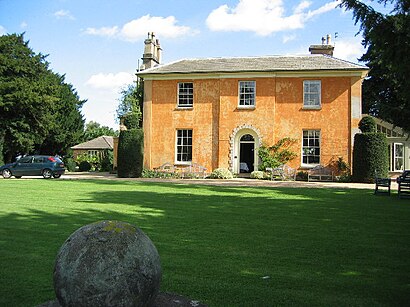
Langar Hall Address: Church Lane street in Rushcliffe
Attractions near Langar Hall
Langar Hall Hotel,Langar Hall Hotel & Restaurant,Langar,Vale Bakery LTD T A Belvoir Bakery,Barnstone,Granby,Cropwell Bishop Parish Council,Abacus Jockey,Harby Village Shop,Pizza Pals,Amazon Counter-Post Office Harby,Alvey & Towers,Vale Of Belvoir Shotokan Karate Club,Badger Village,Marstons Plc,Post Office,Harby,St Mary the Virgin Parish Church. Harby. Leicestershire,Knowledge File,RTM SHow to get to popular attractions in Rushcliffe with public transportation
Gedling, Gedling,Soar Valley Way, Leicester,Forest Fields, Nottingham,British Gas Museum, Leicester,Leicester Royal Infirmary, Leicester,Nuffield Health Nottingham Fitness & Wellbeing Gym, Gedling,Tesco Extra, Leicester,Wicksteed Park, Kettering,Outwood Academy Newbold, Chesterfield,Kings Mill Hospital, Ashfield,David Lloyd Nottingham, Nottingham,Nando's, Kettering,Bilborough College, Nottingham,Asda, Rushcliffe,Colwick Country Park, Nottingham,Chequered Flag (Hungry Horse), Corby,Kettering General Hospital, Kettering,Bagworth, Hinckley And Bosworth,Morrisons Distribution Centre, Northampton,Western Park, LeicesterGet around Rushcliffe by public transport!
Travelling around Rushcliffe has never been so easy. See step by step directions as you travel to any attraction, street or major public transport station. View bus and train timetables, arrival times, service alerts and detailed routes on a map, so you know exactly how to get to anywhere in Rushcliffe.
When travelling to any destination around Rushcliffe use Moovit's Live Directions with Get Off Notifications to know exactly where and how far to walk, how long to wait for your line , and how many stops are left. Moovit will alert you when it’s time to get off — no need to constantly re-check whether yours is the next stop.
Wondering how to use public transport in Rushcliffe or how to pay for public transport in Rushcliffe? Moovit public transport app can help you navigate your way with public transport easily, and at minimum cost. It includes public transport fees, ticket prices, and costs. Looking for a map of Rushcliffe public transport lines? Moovit public transport app shows all public transport maps in Rushcliffe with all bus or train routes and stops on an interactive map.
Rushcliffe has 2 transport type(s), including: bus or train, operated by several transport agencies, including National Rail, Ashbourne Community Transport, Delaine Buses, Arriva Midlands, Centrebus, Our Centre, Hulleys of Baslow, D & G Bus, Stagecoach East Midlands, North Lincolnshire Council, National Rail, Roberts Coaches, Hawkes Coaches, Lawson's of Corby and East Yorkshire