See Longthorpe Tower, Peterborough, on the map
Directions to Longthorpe Tower (Peterborough) with public transport
The following transport lines have routes that pass near Longthorpe Tower
 Bus:
Bus: - Train:
How to get to Longthorpe Tower by bus?
Click on the bus route to see step by step directions with maps, line arrival times and updated time schedules.
How to get to Longthorpe Tower by train?
Click on the train route to see step by step directions with maps, line arrival times and updated time schedules.
Bus stations near Longthorpe Tower in Peterborough
- Woburn Close, Longthorpe,3 min walk,
Bus lines to Longthorpe Tower in Peterborough
- 2,North Bretton,
- 27,Stamford,
- 47,Uppingham,
- 48,Wittering,
What are the nearest stations to Longthorpe Tower?
The nearest stations to Longthorpe Tower are:
- Woburn Close, Longthorpe is 229 meters away, 3 min walk.
Which bus lines stop near Longthorpe Tower?
These bus lines stop near Longthorpe Tower: 2, 9.
Which train lines stop near Longthorpe Tower?
These train lines stop near Longthorpe Tower: CROSSCOUNTRY, EAST MIDLANDS TRAINS.
What’s the nearest bus stop to Longthorpe Tower in Peterborough?
The nearest bus stop to Longthorpe Tower in Peterborough is Woburn Close, Longthorpe. It’s a 3 min walk away.
See Longthorpe Tower, Peterborough, on the map
Public Transit to Longthorpe Tower in Peterborough
Wondering how to get to Longthorpe Tower in Peterborough, United Kingdom? Moovit helps you find the best way to get to Longthorpe Tower with step-by-step directions from the nearest public transit station.
Moovit provides free maps and live directions to help you navigate through your city. View schedules, routes, timetables, and find out how long does it take to get to Longthorpe Tower in real time.
Looking for the nearest stop or station to Longthorpe Tower? Check out this list of stops closest to your destination: Woburn Close.
Bus:Train:
Want to see if there’s another route that gets you there at an earlier time? Moovit helps you find alternative routes or times. Get directions from and directions to Longthorpe Tower easily from the Moovit App or Website.
We make riding to Longthorpe Tower easy, which is why over 1.5 million users, including users in Peterborough, trust Moovit as the best app for public transit. You don’t need to download an individual bus app or train app, Moovit is your all-in-one transit app that helps you find the best bus time or train time available.
For information on prices of bus and train, costs and ride fares to Longthorpe Tower, please check the Moovit app.
Use the app to navigate to popular places including to the airport, hospital, stadium, grocery store, mall, coffee shop, school, college, and university.
Longthorpe Tower Address: Thorpe Road street in Peterborough
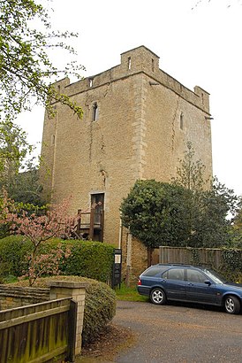
Longthorpe Tower is a 14th-century three-storey tower in the village of Longthorpe, famous for its well-preserved set of medieval murals.Wiki
Attractions near Longthorpe Tower
Thorpe Road,PE3 6sx,Designer Drives,1 The Leys,North Gate,PE3 6xr,PE3 6le,Thurston Gate,PE3 6SS,PE3 6ss,PE3 6lu,9 Apsley Way,Longthorpe,PE3 6ly,PE3 6su,PE3 6st,PE3 9ne,Chris Wells Building Contractors,St Botolph C of E Church,P C D P Services Ltd.How to get to popular attractions in Peterborough with public transportation
Burton Latimer, Kettering,Soar Valley Way, Leicester,James France Building, Charnwood,Tesco Extra, Leicester,Campanile Hotel Northampton, South Northamptonshire,Southwell, Newark And Sherwood,Greenfield Medical Library, Nottingham,Lenton Boulevard, Nottingham,Royal Derby Hospital, Derby,Gedling, Gedling,YBS Group - Lynch Wood, Peterborough,Currys PC World, Nottingham,Ideal World Studios, Peterborough,Bradlaugh Fields, Northampton,The Samuel Hall (Wetherspoon), Nottingham,Ikea, Broxtowe,Market Warsop, Mansfield,Bassett Lowke Halls, Northampton,Sutton-In-Ashfield, Ashfield,Forest Fields, NottinghamGet around Peterborough by public transport!
Travelling around Peterborough has never been so easy. See step by step directions as you travel to any attraction, street or major public transport station. View bus and train timetables, arrival times, service alerts and detailed routes on a map, so you know exactly how to get to anywhere in Peterborough.
When travelling to any destination around Peterborough use Moovit's Live Directions with Get Off Notifications to know exactly where and how far to walk, how long to wait for your line , and how many stops are left. Moovit will alert you when it’s time to get off — no need to constantly re-check whether yours is the next stop.
Wondering how to use public transport in Peterborough or how to pay for public transport in Peterborough? Moovit public transport app can help you navigate your way with public transport easily, and at minimum cost. It includes public transport fees, ticket prices, and costs. Looking for a map of Peterborough public transport lines? Moovit public transport app shows all public transport maps in Peterborough with all bus or train routes and stops on an interactive map.
Peterborough has 2 transport type(s), including: bus or train, operated by several transport agencies, including National Rail, Ashbourne Community Transport, Delaine Buses, Arriva Midlands, Centrebus, Our Centre, Hulleys of Baslow, D & G Bus, Stagecoach East Midlands, North Lincolnshire Council, National Rail, Roberts Coaches, Lawson's of Corby, Hawkes Coaches and East Yorkshire