Directions to Lower Dock Street station (Newport) with public transport
The following transport lines have routes that pass near Lower Dock Street
How to get to Lower Dock Street station by bus?
Click on the bus route to see step by step directions with maps, line arrival times and updated time schedules.
How to get to Lower Dock Street station by train?
Click on the train route to see step by step directions with maps, line arrival times and updated time schedules.
Bus stops near Lower Dock Street in Newport
- Hm Passport Office, Pillgwenlly, 4 min walk,
- Newport Central Police Station, Newport, 4 min walk,
- Emlyn Street, Newport, 4 min walk,
- Pillgwenlly Police Station, Pillgwenlly, 6 min walk,
- Newport (S Wales), 34 min walk,
Bus lines to Lower Dock Street station in Newport
- JF2, Pillgwenlly,
- SJ11, Newport,
- YGI3, Caerleon Road - Ysgol Gyfun Gwent Iscoed,
- X15, Brynmawr - Newport,
- 30, Cardiff - Newport,
- 31A, Newport - St Brides via Castleton, Lighthouse Park,
- 31C, Newport - St Brides via Lighthouse Park, Castleton,
- 35, Newport - Duffryn,
- 36, Newport - Duffryn,
- 37, Newport - Rhiwderin,
- 41, Newport Bus Station - Newport Bus Station via Pillgwenlly,
- 50A, Bargoed - Newport,
- 7, Ringland,
- 40, Maesglas,
- SJ1, Duffryn,
- X74, Newport,
- CROSSCOUNTRY, Derby,
- GREAT WESTERN RAILWAY, Portsmouth Harbour,
- TRANSPORT FOR WALES, Hereford,
What are the nearest stations to Lower Dock Street?
The nearest stations to Lower Dock Street are:
- Hm Passport Office, Pillgwenlly is 231 meters away, 4 min walk.
- Newport Central Police Station, Newport is 284 meters away, 4 min walk.
- Emlyn Street, Newport is 311 meters away, 4 min walk.
- Pillgwenlly Police Station, Pillgwenlly is 421 meters away, 6 min walk.
- Newport (S Wales) is 2583 meters away, 34 min walk.
Which bus lines stop near Lower Dock Street?
These bus lines stop near Lower Dock Street: 151, 29, 30, 31C, 50, X15.
Which train line stops near Lower Dock Street?
TRANSPORT FOR WALES
What’s the nearest bus stop to Lower Dock Street in Newport?
The nearest bus stops to Lower Dock Street in Newport are Hm Passport Office, Pillgwenlly, Newport Central Police Station, Newport and Emlyn Street, Newport. The closest one is a 4 min walk away.
What time is the first train to Lower Dock Street in Newport?
The TRANSPORT FOR WALES is the first train that goes to Lower Dock Street in Newport. It stops nearby at 04:54.
What time is the last train to Lower Dock Street in Newport?
The TRANSPORT FOR WALES is the last train that goes to Lower Dock Street in Newport. It stops nearby at 00:59.
What time is the first bus to Lower Dock Street in Newport?
The X74 is the first bus that goes to Lower Dock Street in Newport. It stops nearby at 06:03.
What time is the last bus to Lower Dock Street in Newport?
The 30 is the last bus that goes to Lower Dock Street in Newport. It stops nearby at 22:56.
See Lower Dock Street, Newport, on the map
Public Transit to Lower Dock Street in Newport
How to get to Lower Dock Street in Newport, United Kingdom?
It’s easy with Moovit. Type in your street address and Moovit’s route finder will locate the fastest way to get you there! Not sure where to get off on the street? Download the Moovit App to find live directions (including where to get off on Lower Dock Street), see timetables and get the estimated arrival times for your favourite bus or train lines.
Looking for the nearest stop or station to Lower Dock Street? Check out this list of closest stops available to your destination: Hm Passport Office; Newport Central Police Station; Emlyn Street; Pillgwenlly Police Station; Newport (S Wales).
Bus: 151, 29, 30, 31C, 50, X15, JF2, SJ11, YGI3, 31A, 7, 40, SJ1, X74, CROSSCOUNTRY, GREAT WESTERN RAILWAY, TRANSPORT FOR WALES.Train: TRANSPORT FOR WALES.
Download the Moovit App to see the current schedule and routes available for Newport. No need to install a special bus app to check the bus time or a train app to get train time. Moovit is the only all-in-one transport app that helps you get where you need to go.
We make riding on public transit to Lower Dock Street easy, which is why over 1.5 million users, including users in Newport trust Moovit as the best app for public transport.
Use the app to navigate to popular places including to the airport, hospital, stadium, grocery store, mall, coffee shop, school, college, and university.
Location: Newport, Wales
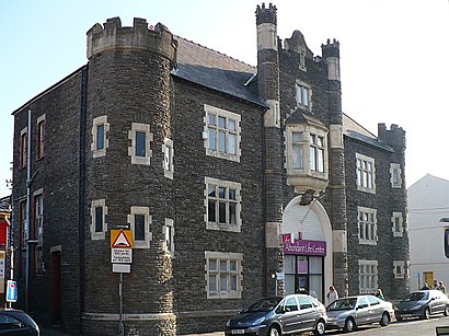
The Lower Dock Street Street drill hall is a former military installation in Newport, Wales.Wiki
Streets near Lower Dock Street, Newport
Get around Newport by public transport!
Travelling around Newport has never been so easy. See step by step directions as you travel to any attraction, street or major public transport station. View bus and train timetables, arrival times, service alerts and detailed routes on a map, so you know exactly how to get to anywhere in Newport.
When travelling to any destination around Newport use Moovit's Live Directions with Get Off Notifications to know exactly where and how far to walk, how long to wait for your line , and how many stops are left. Moovit will alert you when it’s time to get off — no need to constantly re-check whether yours is the next stop.
Wondering how to use public transport in Newport or how to pay for public transport in Newport? Moovit public transport app can help you navigate your way with public transport easily, and at minimum cost. It includes public transport fees, ticket prices, and costs. Looking for a map of Newport public transport lines? Moovit public transport app shows all public transport maps in Newport with all Bus and Train routes and stops on an interactive map.
Wales has 2 transport type(s), including: Bus and Train, operated by several transport agencies, including National Rail, Goodsir, Peter's Minibus Hire, Taf Valley Coaches, SP Cars, Berwyn, Caerphilly County Borough Council, Llew Jones, Thomas Herbert Jones & Partners, Owen's Travelmaster, Clynnog & Trefor / Berwyn Coaches, Lloyds Coaches, Adventure Travel, Pat's Coaches and DANSA