Directions to Matlock Cab (Derbyshire Dales) with public transport
The following transport lines have routes that pass near Matlock Cab
How to get to Matlock Cab by bus?
Click on the bus route to see step by step directions with maps, line arrival times and updated time schedules.
Bus stations near Matlock Cab in Derbyshire Dales
- Imperial Road, Matlock,2 min walk,
- Bakewell Road, Matlock,4 min walk,
- Matlock,5 min walk,
Bus lines to Matlock Cab in Derbyshire Dales
- X17,Wirksworth - Matlock,
- X17,Matlock - Sheffield,
- 6.1|SIXES,Derby - Bakewell,
- 63,Chesterfield - Clay Cross - Matlock,
- 143,East Midlands Designer Outlet - Matlock,
- 143A,East Midlands Designer Outlet - Matlock,
- 157,Matlock - Matlock,
- 158,Matlock - Bonsall,
- 159,Matlock - Matlock,
- 471,Darley Dale - Highfields School,
- 172,Matlock,
- LS|SIXES,Wirksworth - Matlock Bath - Matlock,
- TRANSPEAK,Derby - Belper - Matlock - Bakewell - Buxton,
- 110,Ashbourne - Matlock,
- 111,Ashbourne - Matlock,
- 160,Matlock - Chatsworth House,
- 169,Elton - Highfields School,
- 470,Winster - Highfields School,
- 141,Matlock,
- EAST MIDLANDS RAILWAY,Nottingham,
What are the nearest stations to Matlock Cab?
The nearest stations to Matlock Cab are:
- Imperial Road, Matlock is 77 meters away, 2 min walk.
- Bakewell Road, Matlock is 243 meters away, 4 min walk.
- Matlock is 349 meters away, 5 min walk.
Which bus line stops near Matlock Cab?
X17
What’s the nearest bus stop to Matlock Cab in Derbyshire Dales?
The nearest bus stop to Matlock Cab in Derbyshire Dales is Imperial Road, Matlock. It’s a 2 min walk away.
What time is the first bus to Matlock Cab in Derbyshire Dales?
The X17 is the first bus that goes to Matlock Cab in Derbyshire Dales. It stops nearby at 08:50.
What time is the last bus to Matlock Cab in Derbyshire Dales?
The X17 is the last bus that goes to Matlock Cab in Derbyshire Dales. It stops nearby at 19:16.
See Matlock Cab, Derbyshire Dales, on the map
Public Transit to Matlock Cab in Derbyshire Dales
Wondering how to get to Matlock Cab in Derbyshire Dales, United Kingdom? Moovit helps you find the best way to get to Matlock Cab with step-by-step directions from the nearest public transit station.
Moovit provides free maps and live directions to help you navigate through your city. View schedules, routes, timetables, and find out how long does it take to get to Matlock Cab in real time.
Looking for the nearest stop or station to Matlock Cab? Check out this list of stops closest to your destination: Imperial Road; Bakewell Road; Matlock.
Bus:X176.1|SIXES63143172LS|SIXESTRANSPEAK110111160141EAST MIDLANDS RAILWAY
Want to see if there’s another route that gets you there at an earlier time? Moovit helps you find alternative routes or times. Get directions from and directions to Matlock Cab easily from the Moovit App or Website.
We make riding to Matlock Cab easy, which is why over 1.5 million users, including users in Derbyshire Dales, trust Moovit as the best app for public transit. You don’t need to download an individual bus app or train app, Moovit is your all-in-one transit app that helps you find the best bus time or train time available.
For information on prices of bus, costs and ride fares to Matlock Cab, please check the Moovit app.
Use the app to navigate to popular places including to the airport, hospital, stadium, grocery store, mall, coffee shop, school, college, and university.
Matlock Cab Address: 29 Bank Road Matlock Matlock DE4 3 street in Derbyshire Dales
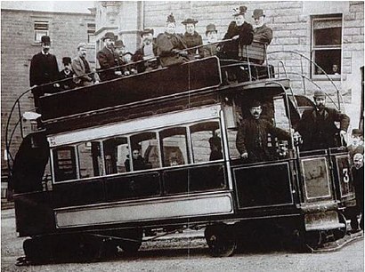
Matlock Cable Tramway was a cable tramway that served the town of Matlock, Derbyshire, UK between 28 March 1893 and 30 September 1927.Wiki
Attractions near Matlock Cab
Derbyshire Districts Citizens Advice Bureau,Sally Botham Estates,Yaz Taxi Matlock,Technical Will Limited,Youth Hostels Association,Derbyshire Wing Chun,Dr Campbell,Springmount Dental & Aesthetics,Reuben Gow Limited,Alderwasley Hall School,Greedy Grubs Limited,Matlock Methodist,Bank Gardens Flat Management Company Limited,Coaching for Change,Derbyshire Police - Matlock Enquiry Office,Geoplan,Peak Chiropody Clinic,Estetica Is Beauty,Matlock Bath Illuminations,Citizens Advice BureauHow to get to popular attractions in Derbyshire Dales with public transportation
Experian Embankment House, Nottingham,David Lloyd Nottingham, Nottingham,Oakham Railway Station (OKM), Rutland,The Castlewood (Brewers Fayre), Bolsover,Currys PC World, Nottingham,Billing Aquadrome, Northampton,Westwood Centre, Peterborough,Nando's, Kettering,Forest Fields, Nottingham,Nettleham, West Lindsey,Nottingham Council House, Nottingham,Western Park, Leicester,Matalan, Corby,Blidworth, Newark And Sherwood,The Nottingham Belfry, Nottingham,RBS Kegworth Data Centre, North West Leicestershire,Rushcliffe Country Park, Rushcliffe,Hotel ibis Chesterfield Centre, Chesterfield,Lenton Boulevard, Nottingham,Ratcliffe Power Station, RushcliffeGet around Derbyshire Dales by public transport!
Travelling around Derbyshire Dales has never been so easy. See step by step directions as you travel to any attraction, street or major public transport station. View bus and train timetables, arrival times, service alerts and detailed routes on a map, so you know exactly how to get to anywhere in Derbyshire Dales.
When travelling to any destination around Derbyshire Dales use Moovit's Live Directions with Get Off Notifications to know exactly where and how far to walk, how long to wait for your line , and how many stops are left. Moovit will alert you when it’s time to get off — no need to constantly re-check whether yours is the next stop.
Wondering how to use public transport in Derbyshire Dales or how to pay for public transport in Derbyshire Dales? Moovit public transport app can help you navigate your way with public transport easily, and at minimum cost. It includes public transport fees, ticket prices, and costs. Looking for a map of Derbyshire Dales public transport lines? Moovit public transport app shows all public transport maps in Derbyshire Dales with all bus routes and stops on an interactive map.
Derbyshire Dales has 1 transport type(s), including: bus, operated by several transport agencies, including National Rail, Ashbourne Community Transport, Delaine Buses, Arriva Midlands, Centrebus, Our Centre, Hulleys of Baslow, D & G Bus, Stagecoach East Midlands, North Lincolnshire Council, National Rail, Roberts Coaches, Lawson's of Corby, Hawkes Coaches and East Yorkshire