See Newlands Rugby Stadium, Wynberg, on the map
Directions to Newlands Rugby Stadium (Wynberg) with public transport
The following transport lines have routes that pass near Newlands Rugby Stadium
 Train:
How to get to Newlands Rugby Stadium by train?
Click on the train route to see step by step directions with maps, line arrival times and updated time schedules.
Train stations near Newlands Rugby Stadium in Wynberg
- Newlands,6 min walk,
What are the nearest stations to Newlands Rugby Stadium?
The nearest stations to Newlands Rugby Stadium are:
- Newlands is 406 meters away, 6 min walk.
Which train line stops near Newlands Rugby Stadium?
SOUTHERN LINE
What’s the nearest train station to Newlands Rugby Stadium in Wynberg?
The nearest train station to Newlands Rugby Stadium in Wynberg is Newlands. It’s a 6 min walk away.
What time is the first train to Newlands Rugby Stadium in Wynberg?
The SOUTHERN LINE is the first train that goes to Newlands Rugby Stadium in Wynberg. It stops nearby at 03:07.
What time is the last train to Newlands Rugby Stadium in Wynberg?
The SOUTHERN LINE is the last train that goes to Newlands Rugby Stadium in Wynberg. It stops nearby at 03:15.
See Newlands Rugby Stadium, Wynberg, on the map
Public Transit to Newlands Rugby Stadium in Wynberg
Wondering how to get to Newlands Rugby Stadium in Wynberg, South Africa? Moovit helps you find the best way to get to Newlands Rugby Stadium with step-by-step directions from the nearest public transit station.
Moovit provides free maps and live directions to help you navigate through your city. View schedules, routes, timetables, and find out how long does it take to get to Newlands Rugby Stadium in real time.
Looking for the nearest stop or station to Newlands Rugby Stadium? Check out this list of stops closest to your destination: Newlands.
Train:
Want to see if there’s another route that gets you there at an earlier time? Moovit helps you find alternative routes or times. Get directions from and directions to Newlands Rugby Stadium easily from the Moovit App or Website.
We make riding to Newlands Rugby Stadium easy, which is why over 1.5 million users, including users in Wynberg, trust Moovit as the best app for public transit. You don’t need to download an individual bus app or train app, Moovit is your all-in-one transit app that helps you find the best bus time or train time available.
For information on prices of train and bus, costs and ride fares to Newlands Rugby Stadium, please check the Moovit app.
Use the app to navigate to popular places including to the airport, hospital, stadium, grocery store, mall, coffee shop, school, college, and university.
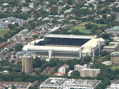
Newlands Rugby Stadium Address: Boundary Rd. street in Wynberg
Attractions near Newlands Rugby Stadium
DHL Newlands,Sporting Chance,Newlands Stadium,Liesbeek River Trail,Optifit Walk & Run Health Programme,Grucox Medical,M P Schwellnus,Kelvin Grove Club,SAB Newlands Brewery,Newlands Cricket Ground,PPC Newlands Cricket Ground,Western Province Cricket Association,Diana Inglis - Educational Psychologist,Ragsdale Kim,George GCW,Great Westerford Building,Gate B,CARNANDA INVESTMENTS CC,Great Westerford High School,Oaks Grass EmbankmentHow to get to popular attractions in Wynberg with public transportation
Muizenberg Beach, Simon Town,Bishop Lavis, Bellville,Waterstone Village, Somerset West,Philippi Train Station, Mitchells Plain,Cape Fertility Clinic, Wynberg,Kalk Bay, Simon Town,Planning & Building Development, South Peninsula Municipality, Wynberg,Reygersdal Post Office, Atlantis, Malmesbury,Cotton On Access Park, Cape,Snowparts, Bellville,Paarl, Paarl,Boland College, Strand Campus, Somerset West,Greenmarket Square, Goodwood,Hofmeyr St Surgery, Goodwood,Letterstedt House, Newlands on Main, Wynberg,Varsity College, Kuils River,Gordon High School, Somerset West,Grand Parade, Goodwood,Melomed Private Hospital Gatesville, Cape,Swingers Club & Bar, WynbergGet around Wynberg by public transport!
Travelling around Wynberg has never been so easy. See step by step directions as you travel to any attraction, street or major public transport station. View bus and train timetables, arrival times, service alerts and detailed routes on a map, so you know exactly how to get to anywhere in Wynberg.
When travelling to any destination around Wynberg use Moovit's Live Directions with Get Off Notifications to know exactly where and how far to walk, how long to wait for your line , and how many stops are left. Moovit will alert you when it’s time to get off — no need to constantly re-check whether yours is the next stop.
Wondering how to use public transport in Wynberg or how to pay for public transport in Wynberg? Moovit public transport app can help you navigate your way with public transport easily, and at minimum cost. It includes public transport fees, ticket prices, and costs. Looking for a map of Wynberg public transport lines? Moovit public transport app shows all public transport maps in Wynberg with all train or bus routes and stops on an interactive map.
Wynberg has 2 transport type(s), including: train or bus, operated by several transport agencies, including Golden Arrow, MyCiTi, Metrorail Western Cape, Intercape and City Sightseeing Cpt