See Newtown Park, Bo'Ness on the map
Directions to Newtown Park, Bo'Ness with public transportation
The following transport lines have routes that pass near Newtown Park, Bo'Ness
 Bus:
Bus: - Train:
How to get to Newtown Park, Bo'Ness by bus?
Click on the bus route to see step by step directions with maps, line arrival times and updated time schedules.
How to get to Newtown Park, Bo'Ness by train?
Click on the train route to see step by step directions with maps, line arrival times and updated time schedules.
Bus stations near Newtown Park, Bo'Ness
- Newtown Park, Bo'Ness,1 min walk,
- Richmond Terrace, Bo'Ness,5 min walk,
Bus routes to Newtown Park, Bo'Ness
- 2,Boness,
- 2A,Boness,
- 909,Edinburgh,
What are the nearest stations to Newtown Park, Bo'Ness?
The nearest stations to Newtown Park, Bo'Ness are:
- Newtown Park, Bo'Ness is 32 meters away, 1 min walk.
- Richmond Terrace, Bo'Ness is 352 meters away, 5 min walk.
Which bus lines stop near Newtown Park, Bo'Ness?
These bus lines stop near Newtown Park, Bo'Ness: 2, 909, F45.
Which train line stops near Newtown Park, Bo'Ness?
SCOTRAIL
What’s the nearest bus stop to Newtown Park, Bo'Ness?
The nearest bus stop to Newtown Park, Bo'Ness is Newtown Park, Bo'Ness. It’s a 1 min walk away.
See Newtown Park, Bo'Ness on the map
Public Transportation to Newtown Park, Bo'Ness
Wondering how to get to Newtown Park, Bo'Ness, United Kingdom? Moovit helps you find the best way to get to Newtown Park, Bo'Ness with step-by-step directions from the nearest public transit station.
Moovit provides free maps and live directions to help you navigate through your city. View schedules, routes, timetables, and find out how long does it take to get to Newtown Park, Bo'Ness in real time.
Looking for the nearest stop or station to Newtown Park, Bo'Ness? Check out this list of stops closest to your destination: Newtown Park; Richmond Terrace.
Bus:Train:
Want to see if there’s another route that gets you there at an earlier time? Moovit helps you find alternative routes or times. Get directions from and directions to Newtown Park, Bo'Ness easily from the Moovit App or Website.
We make riding to Newtown Park, Bo'Ness easy, which is why over 1.5 million users, including users in Bo'Ness, trust Moovit as the best app for public transit. You don’t need to download an individual bus app or train app, Moovit is your all-in-one transit app that helps you find the best bus time or train time available.
For information on prices of bus and train, costs and ride fares to Newtown Park, Bo'Ness, please check the Moovit app.
Use the app to navigate to popular places including to the airport, hospital, stadium, grocery store, mall, coffee shop, school, college, and university.
Newtown Park, Bo'Ness Address: 110 Jamieson Avenue Bo'Ness Bo'Ness EH51 0JX street in Bo'Ness
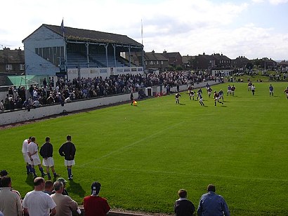
Newtown Park is a football ground in Bo'ness, Scotland. It is the home ground of Bo'ness United, and was previously the home ground of Bo'ness F.C..Wiki
Attractions near Newtown Park, Bo'Ness
Newtown Bar,Cooperative,Peking Cuisine,Newtown Co-OP, Bo'Ness,Boness Frier,Bo'Ness Football Club,Co-Op,Linlithgow Road,Eh51 0hx,Eh51 0jx,Bo'Ness Chemical Workers Social Club,Eh51 0jz,Bo'Ness Barracuda,R M Computercare Services,Eh51 0ds,St Marys Church,Eh51 0hu,CR Cleaning Services,Scotmid,Eh51 0laHow to get to popular attractions in Bo'Ness with public transportation
Edinburgh Castle, Edinburgh,St Andrews University Library, St Andrews,Jurys Inn Glasgow, Glasgow,South Queensferry, Queensferry,River Clyde, Glasgow City,Virgin Active, Glasgow,Aberdeen International Airport (ABZ), Dyce,The Queen Elizabeth University Hospital Campus, Glasgow,Tesco, Stirling,Soar at intu Braehead, Renfrew,Queen's Park, Glasgow,Ninewells Hospital & Medical School, Dundee,IKEA, Loanhead,Tynecastle Park, Edinburgh,Starbucks, Edinburgh,Stirling Railway Station (STG), Stirling,Queen Elizabeth University Hospital, Glasgow,Annandale Water Motorway Services (RoadChef), Dumfries And Galloway,The Queens Arms, Edinburgh,Asda, GlasgowGet around Bo'Ness by public transport!
Travelling around Bo'Ness has never been so easy. See step by step directions as you travel to any attraction, street or major public transport station. View bus and train timetables, arrival times, service alerts and detailed routes on a map, so you know exactly how to get to anywhere in Bo'Ness.
When travelling to any destination around Bo'Ness use Moovit's Live Directions with Get Off Notifications to know exactly where and how far to walk, how long to wait for your line , and how many stops are left. Moovit will alert you when it’s time to get off — no need to constantly re-check whether yours is the next stop.
Wondering how to use public transport in Bo'Ness or how to pay for public transport in Bo'Ness? Moovit public transport app can help you navigate your way with public transport easily, and at minimum cost. It includes public transport fees, ticket prices, and costs. Looking for a map of Bo'Ness public transport lines? Moovit public transport app shows all public transport maps in Bo'Ness with all bus or train routes and stops on an interactive map.
Bo'Ness has 2 transport type(s), including: bus or train, operated by several transport agencies, including First Greater Glasgow, First Aberdeen, Lothian Buses, McGill's Bus Service, Stagecoach East Scotland, Stagecoach Bluebird, Xplore Dundee, Community Transport Glasgow, Prentice Westwood, McCall's Coaches, J P Minibus, National Rail, R Robertson & Son, Burnbrae Garage and Ember