Pinner station - Wednesday schedule
| Line | Direction | Time |
|---|---|---|
| METROPOLITAN | Watford - Aldgate | 05:44 |
| METROPOLITAN | Aldgate - Watford | 05:48 |
| DLR | Southbound | 05:49 |
| METROPOLITAN | Aldgate - Watford | 05:52 |
| DLR | Southbound | 05:56 |
| METROPOLITAN | Aldgate - Amersham | 05:56 |
| METROPOLITAN | Aldgate - Amersham | 06:01 |
| METROPOLITAN | Watford - Aldgate | 06:02 |
| METROPOLITAN | Aldgate - Watford | 06:08 |
| DLR | Southbound | 06:10 |
| METROPOLITAN | Aldgate - Chesham | 06:16 |
| METROPOLITAN | Watford - Aldgate | 06:17 |
| METROPOLITAN | Aldgate - Watford | 06:19 |
| DLR | Northbound | 06:20 |
| METROPOLITAN | Aldgate - Amersham | 06:23 |
| METROPOLITAN | Watford - Aldgate | 06:25 |
| DLR | Southbound | 06:30 |
| METROPOLITAN | Aldgate - Watford | 06:32 |
| METROPOLITAN | Watford - Aldgate | 06:34 |
| DLR | Southbound | 06:38 |
| METROPOLITAN | Aldgate - Watford | 06:40 |
| METROPOLITAN | Watford - Aldgate | 06:43 |
| METROPOLITAN | Aldgate - Watford | 06:47 |
| METROPOLITAN | Watford - Aldgate | 06:48 |
| METROPOLITAN | Aldgate - Chesham | 06:50 |
See Pinner on the map
Directions to Pinner with public transportation
The following transport lines have routes that pass near Pinner
 Bus:
Bus: - Train:
- Tube:
How to get to Pinner by bus?
Click on the bus route to see step by step directions with maps, line arrival times and updated time schedules.
How to get to Pinner by train?
Click on the train route to see step by step directions with maps, line arrival times and updated time schedules.
How to get to Pinner by Tube?
Click on the Tube route to see step by step directions with maps, line arrival times and updated time schedules.
Bus stations near Pinner
- Pinner Library (A),5 min walk,
- Eastcote Road (F),7 min walk,
Tube stations near Pinner
- Northwood Hills,25 min walk,
- Eastcote,30 min walk,
Bus routes to Pinner
- H11,Mount Vernon Hospital,
- H13,Ruislip Lido,
- 183,Pinner,
What are the nearest stations to Pinner?
The nearest stations to Pinner are:
- Pinner Library (A) is 324 meters away, 5 min walk.
- Eastcote Road (F) is 488 meters away, 7 min walk.
- Northwood Hills is 1920 meters away, 25 min walk.
- Eastcote is 2323 meters away, 30 min walk.
Which bus lines stop near Pinner?
These bus lines stop near Pinner: 183, H12, H13.
Which train line stops near Pinner?
OVERGROUND
Which Tube line stops near Pinner?
METROPOLITAN
What’s the nearest Tube station to Pinner?
The nearest Tube station to Pinner is Northwood Hills. It’s a 25 min walk away.
What’s the nearest bus stop to Pinner?
The nearest bus stop to Pinner is Pinner Library (A). It’s a 5 min walk away.
What time is the first Tube to Pinner?
The METROPOLITAN is the first Tube that goes to Pinner. It stops nearby at 05:22.
What time is the last Tube to Pinner?
The PICCADILLY is the last Tube that goes to Pinner. It stops nearby at 01:21.
What time is the first bus to Pinner?
The 183 is the first bus that goes to Pinner. It stops nearby at 05:15.
What time is the last bus to Pinner?
The 183 is the last bus that goes to Pinner. It stops nearby at 01:55.
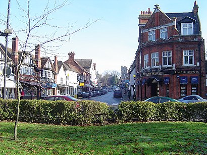
Pinner station
 Taken by Jason O.
See Pinner on the map
Public transport to Pinner station
Looking for directions to Pinner in Pinner, United Kingdom?
Download the Moovit App to find the current schedule and step-by-step directions for Bus, Tube or Train routes that pass through Pinner.
Looking for the nearest stops closest to Pinner ? Check out this list of closest stops to your destination: Pinner Library (A); Eastcote Road (F); Northwood Hills; Eastcote.
Bus:Train:Tube:
We make riding on public transit to Pinner easy, which is why over 1.5 million users, including users in Pinner trust Moovit as the best app for public transit.
Use the app to navigate to popular places including to the airport, hospital, stadium, grocery store, mall, coffee shop, school, college, and university.
The station has the following entrances: Marsh Road - Sainsbury's
The first line to this station is METROPOLITAN, at 05:44, and the last line is METROPOLITAN at 00:54.
12 Barters Walk, London, England, United Kingdom
This station serves Transport for London and London Underground’s lines
Popular routes to Pinner
Popular routes from Pinner
Popular public transport stations in Pinner
Uxbridge,Ashurst (Kent),Preston Circus, Brighton,Ickenham,Acton Main Line,Redbridge,Maidenhead Railway Station, Maidenhead Town Centre,Bull Lane / North Middlesex Hospital (Z),Reading Railair, Reading Town Centre,Eton College, Eton,Ealing Hospital (W),Hayes & Harlington,Kidbrooke Park Road / Aldi Store (H),London Aquatics Centre (H),Willesden Green,Acton Central,High Street Kensington,The Brewery,Pettits Lane Romford (N),Barnet Hospital A&E DepartmentGet around Pinner by public transport!
Travelling around Pinner has never been so easy. See step by step directions as you travel to any attraction, street or major public transport station. View bus and train timetables, arrival times, service alerts and detailed routes on a map, so you know exactly how to get to anywhere in Pinner.
When travelling to any destination around Pinner use Moovit's Live Directions with Get Off Notifications to know exactly where and how far to walk, how long to wait for your line , and how many stops are left. Moovit will alert you when it’s time to get off — no need to constantly re-check whether yours is the next stop.
Wondering how to use public transport in Pinner or how to pay for public transport in Pinner? Moovit public transport app can help you navigate your way with public transport easily, and at minimum cost. It includes public transport fees, ticket prices, and costs. Looking for a map of Pinner public transport lines? Moovit public transport app shows all public transport maps in Pinner with all bus, Tube or train routes and stops on an interactive map.
Pinner has 3 transport type(s), including: bus, Tube or train, operated by several transport agencies, including London Underground, London Buses, Transport for London, London Tramlink, Transport for London, National Rail, Bluestar, Berry's Coaches, Oxford Bus Company, Stagecoach West, Community First Wessex, Cresta Coaches, D & P Boat Hire, First Portsmouth, Fareham & Gosport and FYTbus