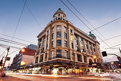
Prahran station - Sunday schedule
| Line | Direction | Time |
|---|---|---|
| SANDRINGHAM | Sandringham | 05:26 |
| SANDRINGHAM | City (Flinders Street) | 06:18 |
| SANDRINGHAM | Sandringham | 06:26 |
| SANDRINGHAM | City (Flinders Street) | 07:18 |
| SANDRINGHAM | Sandringham | 07:26 |
| SANDRINGHAM | City (Flinders Street) | 07:58 |
| SANDRINGHAM | Sandringham | 08:26 |
| SANDRINGHAM | City (Flinders Street) | 08:38 |
| SANDRINGHAM | Sandringham | 09:06 |
| SANDRINGHAM | City (Flinders Street) | 09:18 |
| SANDRINGHAM | Sandringham | 09:46 |
| SANDRINGHAM | City (Flinders Street) | 09:58 |
| SANDRINGHAM | City (Flinders Street) | 10:18 |
| SANDRINGHAM | Sandringham | 10:26 |
| SANDRINGHAM | City (Flinders Street) | 10:38 |
| SANDRINGHAM | Sandringham | 10:46 |
| SANDRINGHAM | City (Flinders Street) | 10:58 |
| SANDRINGHAM | Sandringham | 11:06 |
| SANDRINGHAM | City (Flinders Street) | 11:18 |
| SANDRINGHAM | Sandringham | 11:26 |
| SANDRINGHAM | City (Flinders Street) | 11:38 |
| SANDRINGHAM | Sandringham | 11:46 |
| SANDRINGHAM | City (Flinders Street) | 11:58 |
| SANDRINGHAM | City (Flinders Street) | 12:06 |
| SANDRINGHAM | Sandringham | 12:06 |
See Prahran on the map
Directions to Prahran with public transportation
The following transport lines have routes that pass near Prahran
Bus:
Train:
Tram:
How to get to Prahran by Bus?
Click on the Bus route to see step by step directions with maps, line arrival times and updated time schedules.
How to get to Prahran by Train?
Click on the Train route to see step by step directions with maps, line arrival times and updated time schedules.
Bus stations near Prahran
- Braille Library/Commercial Rd (South Yarra),3 min walk,
- Commercial Rd/Punt Rd (South Yarra),6 min walk,
Tram stations near Prahran
- 30-Prahran Station/High St (Prahran),3 min walk,
- 46-Chatham St/Chapel St (Prahran),6 min walk,
Bus routes to Prahran
- 603,Brighton Beach Station - Alfred Hospital,
- 604,Gardenvale - Alfred Hospital,
- 246,Elsternwick,
What are the nearest stations to Prahran?
The nearest stations to Prahran are:
- Braille Library/Commercial Rd (South Yarra) is 158 meters away, 3 min walk.
- 30-Prahran Station/High St (Prahran) is 198 meters away, 3 min walk.
- Commercial Rd/Punt Rd (South Yarra) is 394 meters away, 6 min walk.
- 46-Chatham St/Chapel St (Prahran) is 400 meters away, 6 min walk.
Which Bus lines stop near Prahran?
These Bus lines stop near Prahran: 246, 603, 604
Which Train lines stop near Prahran?
These Train lines stop near Prahran: SANDRINGHAM
Which Tram lines stop near Prahran?
These Tram lines stop near Prahran: 6
What’s the nearest tram station to Prahran?
The nearest tram station to Prahran is 30-Prahran Station/High St (Prahran). It’s a 3 min walk away.
What’s the nearest bus stop to Prahran?
The nearest bus stop to Prahran is Braille Library/Commercial Rd (South Yarra). It’s a 3 min walk away.
What time is the first Tram to Prahran?
The 6 is the first Tram that goes to Prahran. It stops nearby at 07:11.
What time is the last Tram to Prahran?
The 6 is the last Tram that goes to Prahran. It stops nearby at 00:52.
What time is the first Bus to Prahran?
The 246 is the first Bus that goes to Prahran. It stops nearby at 06:50.
What time is the last Bus to Prahran?
The 604 is the last Bus that goes to Prahran. It stops nearby at 23:36.
How much is the Bus fare to Prahran?
The Bus fare to Prahran costs about $3.30 - $5.30.
Prahran station
 Taken by Peter K.
See Prahran on the map

Public transport to Prahran station
Looking for directions to Prahran in Prahran, Australia?
Download the Moovit App to find the current schedule and step-by-step directions for Train, Bus or Tram routes that pass through Prahran.
Looking for the nearest stops closest to Prahran ? Check out this list of closest stops to your destination: Braille Library/Commercial Rd (South Yarra); 30-Prahran Station/High St (Prahran); Commercial Rd/Punt Rd (South Yarra); 46-Chatham St/Chapel St (Prahran).
Bus:Train:Tram:
We make riding on public transit to Prahran easy, which is why over 1.5 million users, including users in Prahran trust Moovit as the best app for public transit.
Use the app to navigate to popular places including to the airport, hospital, stadium, grocery store, mall, coffee shop, school, college, and university.
The station has the following entrances: Porter St and Greville St
The first line to this station is SANDRINGHAM, at 05:26, and the last line is SANDRINGHAM at 00:26.
90 Greville Street, Prahran, VIC, Australia
This station serves PTV Metropolitan Trains’s lines

Popular routes to Prahran
Popular routes from Prahran
Bus stops near Prahran
Tram stations near Prahran
Popular public transport stations in Prahran
- Merinda Park
- Jordanville
- Chisholm Tafe/Stud Rd (Dandenong)
- Box Hill Institute/Jarlo Dr (Lilydale)
- Bungower Rd/Nepean Hwy (Mornington)
- Benalla Railway Station (Benalla)
- The Village Warralily Sc/Central Bvd (Armstrong Creek)
- Maribyrnong Rsl/Raleigh Rd (Maribyrnong)
- Shepparton Railway Station (Shepparton)
- Dorset Rd/Mt Dandenong Rd (Croydon)
- Cochranes Rd/Chesterville Rd (Moorabbin)
- Brentford Square Sc/Stevens Rd (Vermont)
- Fishermans Bend/Wharf Rd (Port Melbourne)
- Douglas St/Heatherton Rd (Noble Park)
- Balaclava
- Casey Central Sc/Narre Warren-Cranbourne Rd (Narre Warren South)
- Geelong Station/Railway Tce (Geelong)
- Ashley St/Barkly St (West Footscray)
- Dohertys Rd/Fitzgerald Rd (Laverton North)
- Collins St/Queen St (Melbourne City)