Directions to Roma Street Parklands (City) with public transport
The following transport lines have routes that pass near Roma Street Parklands
How to get to Roma Street Parklands by bus?
Click on the bus route to see step by step directions with maps, line arrival times and updated time schedules.
Bus stations near Roma Street Parklands in City
- Wickham Tce Near Dark St, Stop 3a,4 min walk,
- Wickham Terrace Stop 174 at Albert Park,6 min walk,
- College Rd Near Countess St, Stop 3b,7 min walk,
- Roma Street Busway, Platform 2,8 min walk,
- Roma Street Busway, Platform 1,9 min walk,
- Roma Street Stop 125 at Transit Centre,10 min walk,
- Roma Street Stop 124 at Roma Street Station,10 min walk,
- Countess Street Busway Holding,16 min walk,
Train stations near Roma Street Parklands in City
- South Brisbane Station,18 min walk,
- Central Station,33 min walk,
Ferry stations near Roma Street Parklands in City
- North Quay Ferry Terminal,22 min walk,
- Riverside Ferry Terminal,26 min walk,
Bus lines to Roma Street Parklands in City
- 372,Ashgrove - City,
- 373,Ashgrove - City Via Ashgrove Avenue,
- 433,Kenmore South - City,
- 445,Fig Tree Pocket - City,
- 735,Southport - Nerang Station Via Ashmore,
- 736,Broadbeach - Nerang Via Highland Park,
- 30,City, Queen St,
- 390,Mitchelton - City,
- 739,Uni-hospital - Nerang Via Ashmore,
- 740,Surfers Paradise - Nerang Via Ashmore,
- EK1,Herston - Woolloongabba Via City,
- 61,Ashgrove Shops - Coorparoo Via City,
- 66,Uq Lakes - Rbwh Via City,
- 111,Eight Mile Plains - City,
- 222,Carindale - City Express Via Eastern Busway,
- 325,Boondall - City Express,
- 330,Bracken Ridge - City Express,
- 333,Chermside - City,
- 340,Carseldine - Woolloongabba Express Via City,
- P343,Aspley - City Pre-paid Rocket,
What are the nearest stations to Roma Street Parklands?
The nearest stations to Roma Street Parklands are:
- Wickham Tce Near Dark St, Stop 3a is 293 meters away, 4 min walk.
- Wickham Terrace Stop 174 at Albert Park is 408 meters away, 6 min walk.
- College Rd Near Countess St, Stop 3b is 484 meters away, 7 min walk.
- Roma Street Busway, Platform 2 is 544 meters away, 8 min walk.
- Roma Street Busway, Platform 1 is 605 meters away, 9 min walk.
- Roma Street Stop 125 at Transit Centre is 688 meters away, 10 min walk.
- Roma Street Stop 124 at Roma Street Station is 725 meters away, 10 min walk.
- Countess Street Busway Holding is 1154 meters away, 16 min walk.
- South Brisbane Station is 1388 meters away, 18 min walk.
- North Quay Ferry Terminal is 1684 meters away, 22 min walk.
- Riverside Ferry Terminal is 2026 meters away, 26 min walk.
- Central Station is 2526 meters away, 33 min walk.
Which bus lines stop near Roma Street Parklands?
These bus lines stop near Roma Street Parklands: 222, 345, 373, 376, 415, 445, P221, P343, P456.
Which train lines stop near Roma Street Parklands?
These train lines stop near Roma Street Parklands: BEEN, CLEV, FERN, IPSW, SPRI.
What’s the nearest train station to Roma Street Parklands in City?
The nearest train station to Roma Street Parklands in City is South Brisbane Station. It’s a 18 min walk away.
What’s the nearest bus stop to Roma Street Parklands in City?
The nearest bus stop to Roma Street Parklands in City is Wickham Tce Near Dark St, Stop 3a. It’s a 4 min walk away.
What’s the nearest ferry station to Roma Street Parklands in City?
The nearest ferry station to Roma Street Parklands in City is North Quay Ferry Terminal. It’s a 22 min walk away.
What time is the first train to Roma Street Parklands in City?
The BEEN is the first train that goes to Roma Street Parklands in City. It stops nearby at 04:04.
What time is the last train to Roma Street Parklands in City?
The GOLD is the last train that goes to Roma Street Parklands in City. It stops nearby at 01:01.
What time is the first bus to Roma Street Parklands in City?
The 111 is the first bus that goes to Roma Street Parklands in City. It stops nearby at 05:13.
What time is the last bus to Roma Street Parklands in City?
The 111 is the last bus that goes to Roma Street Parklands in City. It stops nearby at 00:07.
What time is the first ferry to Roma Street Parklands in City?
The CITY HOPPER - NORTH QUAY is the first ferry that goes to Roma Street Parklands in City. It stops nearby at 05:27.
What time is the last ferry to Roma Street Parklands in City?
The CITY HOPPER - NORTH QUAY is the last ferry that goes to Roma Street Parklands in City. It stops nearby at 00:27.
See Roma Street Parklands, City, on the map
Public Transit to Roma Street Parklands in City
Wondering how to get to Roma Street Parklands in City, Australia? Moovit helps you find the best way to get to Roma Street Parklands with step-by-step directions from the nearest public transit station.
Moovit provides free maps and live directions to help you navigate through your city. View schedules, routes, timetables, and find out how long does it take to get to Roma Street Parklands in real time.
Looking for the nearest stop or station to Roma Street Parklands? Check out this list of stops closest to your destination: Wickham Tce Near Dark St; Wickham Terrace Stop 174 at Albert Park; College Rd Near Countess St; Roma Street Busway; Roma Street Busway; Roma Street Stop 125 at Transit Centre; Roma Street Stop 124 at Roma Street Station; Countess Street Busway Holding; South Brisbane Station; North Quay Ferry Terminal; Riverside Ferry Terminal; Central Station.
Bus:222345373376415445P221P343P45637243373530390739740Train:BEENCLEVFERNIPSWSPRIAIRPBRBRBRSHCABOREDCSUNSFerry:CITY CAT DOWNSTREAM - NORTHSHORE HAMILTONCITY CAT UPSTREAM - UQCITY HOPPER - NORTH QUAYCITY HOPPER - SYDNEY STREET
Want to see if there’s another route that gets you there at an earlier time? Moovit helps you find alternative routes or times. Get directions from and directions to Roma Street Parklands easily from the Moovit App or Website.
We make riding to Roma Street Parklands easy, which is why over 1.5 million users, including users in City, trust Moovit as the best app for public transit. You don’t need to download an individual bus app or train app, Moovit is your all-in-one transit app that helps you find the best bus time or train time available.
For information on prices of bus and train, costs and ride fares to Roma Street Parklands, please check the Moovit app.
Use the app to navigate to popular places including to the airport, hospital, stadium, grocery store, mall, coffee shop, school, college, and university.
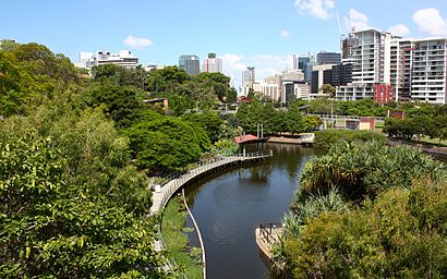
Roma Street Parklands Address: Parkland Boulevard street in City
Attractions near Roma Street Parklands
Roma Street Parkland,Spectacle Garden in Colin Campbell Place,Banyan Lawn,Enchanted Garden,Atm,Brisbane Coach Terminal,The Garden Room,Roma Street Parkland Amphitheatre,JPT Tour Group,Cornerstone Parking,Platform 10,Tilt Train,Platform 10,Platform 9,Farah Persian Restaurant رستوران فرح,Roma Street Railway Station,Mission Australia,Theosophical Society (Brisbane Lodge),Spring Hill Loop - Stop 174,St Andrews War Memorial Hospital Administration BuildingHow to get to popular attractions in City with public transportation
Westfield Garden City, Upper Mount Gravatt,Eatons Hill, Eatons Hill,Noosa Heads, Noosa Heads,Labrador, Labrador,Toowong Village Shopping Centre, Toowong,Mecca Bah, Broadbeach,Queensland University Of Technology, City,Logan Hyperdome, Shailer Park,Brisbane Girls Grammar School, Spring Hill,Dendy Cinemas, Hamilton,Caboolture, Caboolture,Peregian Beach,Sunnybank Hills Shoppingtown, Sunnybank Hills,Southbank Cineplex, South Brisbane,Oxford 152, Bulimba,Victoria Point Lakeside Shopping Centre, Victoria Point,Mooloolaba, Mooloolaba,Sunnybank Railway Station, Sunnybank,RACQ - Fusion Cafe, Eight Mile Plains,James Cook University, CityGet around City by public transport!
Travelling around City has never been so easy. See step by step directions as you travel to any attraction, street or major public transport station. View bus and train timetables, arrival times, service alerts and detailed routes on a map, so you know exactly how to get to anywhere in City.
When travelling to any destination around City use Moovit's Live Directions with Get Off Notifications to know exactly where and how far to walk, how long to wait for your line , and how many stops are left. Moovit will alert you when it’s time to get off — no need to constantly re-check whether yours is the next stop.
Wondering how to use public transport in City or how to pay for public transport in City? Moovit public transport app can help you navigate your way with public transport easily, and at minimum cost. It includes public transport fees, ticket prices, and costs. Looking for a map of City public transport lines? Moovit public transport app shows all public transport maps in City with all bus or train routes and stops on an interactive map.
City has 2 transport type(s), including: bus or train, operated by several transport agencies, including TransLink SEQ, TransLink, TransLink, TransLink, Christensens Bus and Coach, North Stradbroke Island Buses and Griffith Uni Intercampus bus