See Rubery Hill, Rubery & Rednal, on the map
Directions to Rubery Hill (Rubery & Rednal) with public transport
The following transport lines have routes that pass near Rubery Hill
 Bus:
Bus: - Train:
How to get to Rubery Hill by bus?
Click on the bus route to see step by step directions with maps, line arrival times and updated time schedules.
How to get to Rubery Hill by train?
Click on the train route to see step by step directions with maps, line arrival times and updated time schedules.
Bus stations near Rubery Hill in Rubery & Rednal
- Deelands Rd,6 min walk,
- Rubery Lane South,6 min walk,
- Old Stone Close,8 min walk,
- Arden Walk,9 min walk,
- Leach Green Lane,9 min walk,
Train stations near Rubery Hill in Rubery & Rednal
- Longbridge,49 min walk,
Bus lines to Rubery Hill in Rubery & Rednal
- 63,Frankley,
- 202,Halesowen,
- 61,Frankley,
- 27,Frankley Great Park - Highter's Heath,
- 878,King's Norton North - Frankley Great Park,
- 19,Maypole,
- 55,Longbridge,
What are the nearest stations to Rubery Hill?
The nearest stations to Rubery Hill are:
- Deelands Rd is 296 meters away, 6 min walk.
- Rubery Lane South is 298 meters away, 6 min walk.
- Old Stone Close is 492 meters away, 8 min walk.
- Arden Walk is 564 meters away, 9 min walk.
- Leach Green Lane is 581 meters away, 9 min walk.
- Longbridge is 3794 meters away, 49 min walk.
Which bus lines stop near Rubery Hill?
These bus lines stop near Rubery Hill: 202, 27, 63.
Which train line stops near Rubery Hill?
WEST MIDLANDS RAILWAY
What’s the nearest bus stop to Rubery Hill in Rubery & Rednal?
The nearest bus stops to Rubery Hill in Rubery & Rednal are Deelands Rd and Rubery Lane South. The closest one is a 6 min walk away.
What time is the first train to Rubery Hill in Rubery & Rednal?
The WEST MIDLANDS RAILWAY is the first train that goes to Rubery Hill in Rubery & Rednal. It stops nearby at 06:00.
What time is the last train to Rubery Hill in Rubery & Rednal?
The WEST MIDLANDS RAILWAY is the last train that goes to Rubery Hill in Rubery & Rednal. It stops nearby at 23:58.
What time is the first bus to Rubery Hill in Rubery & Rednal?
The 63 is the first bus that goes to Rubery Hill in Rubery & Rednal. It stops nearby at 04:08.
What time is the last bus to Rubery Hill in Rubery & Rednal?
The 63 is the last bus that goes to Rubery Hill in Rubery & Rednal. It stops nearby at 02:29.
See Rubery Hill, Rubery & Rednal, on the map
Public Transit to Rubery Hill in Rubery & Rednal
Wondering how to get to Rubery Hill in Rubery & Rednal, United Kingdom? Moovit helps you find the best way to get to Rubery Hill with step-by-step directions from the nearest public transit station.
Moovit provides free maps and live directions to help you navigate through your city. View schedules, routes, timetables, and find out how long does it take to get to Rubery Hill in real time.
Looking for the nearest stop or station to Rubery Hill? Check out this list of stops closest to your destination: Deelands Rd; Rubery Lane South; Old Stone Close; Arden Walk; Leach Green Lane; Longbridge.
Bus:Train:
Want to see if there’s another route that gets you there at an earlier time? Moovit helps you find alternative routes or times. Get directions from and directions to Rubery Hill easily from the Moovit App or Website.
We make riding to Rubery Hill easy, which is why over 1.5 million users, including users in Rubery & Rednal, trust Moovit as the best app for public transit. You don’t need to download an individual bus app or train app, Moovit is your all-in-one transit app that helps you find the best bus time or train time available.
For information on prices of bus and train, costs and ride fares to Rubery Hill, please check the Moovit app.
Use the app to navigate to popular places including to the airport, hospital, stadium, grocery store, mall, coffee shop, school, college, and university.
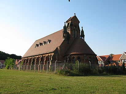
Rubery Hill Address: Cock Hill Lane street in Rubery & Rednal
Rubery Hill Hospital was a mental health facility in Birmingham, England. The Chapel, which still survives, is a Grade II listed building.Wiki
Attractions near Rubery Hill
Rubery Hill,Autumn,DJS Landscapes,Lane Roofing,Raf Decorators,Ta Dah Apps,Acoustics Limited,Headway West Midlands,Headway Birmingham Solihull Trading Limited,Aperfectpropertymaintenance Gmail Com,Paperchain Technology Limited,Evans S of Bournville,Ideal Plumbing,Krispy Kreme,Zetrimira Supplies,Uk Taiho Jutsu Association,McCormack Training Limited,Styled Out Limited,B D Medical,Rubery Lane SouthHow to get to popular attractions in Rubery & Rednal with public transportation
Hilton Birmingham Metropole, Bickenhill,Ricoh Arena, Longford,Corpus Christi Catholic Primary School, Yardley West & Stechford,Coventry Building Society Arena, Longford,Queen Mary's Grammar School, Paddock,Doug Ellis Sports Centre, Perry Barr,Walsall Arboretum, St. Matthew's,Newtown Community Centre, Newtown,Warwick Racecourse, Warwick Aylesford,Aston University, Nechells,Selly Oak, Bournville & Cotteridge,Dudley Zoological Gardens And Castle, Castle And Priory,Birmingham Heartlands Hospital, Heartlands,Tyburn House, Pype Hayes,Longton Bus Station, Broadway And Longton East,Kingstanding Circle, Oscott,Castle Vale, Castle Vale,Olton, Olton,Severn Valley Railway - Bridgnorth Station, Bridgnorth West And Tasley Ed,Edgbaston Cricket Ground, EdgbastonGet around Rubery & Rednal by public transport!
Travelling around Rubery & Rednal has never been so easy. See step by step directions as you travel to any attraction, street or major public transport station. View bus and train timetables, arrival times, service alerts and detailed routes on a map, so you know exactly how to get to anywhere in Rubery & Rednal.
When travelling to any destination around Rubery & Rednal use Moovit's Live Directions with Get Off Notifications to know exactly where and how far to walk, how long to wait for your line , and how many stops are left. Moovit will alert you when it’s time to get off — no need to constantly re-check whether yours is the next stop.
Wondering how to use public transport in Rubery & Rednal or how to pay for public transport in Rubery & Rednal? Moovit public transport app can help you navigate your way with public transport easily, and at minimum cost. It includes public transport fees, ticket prices, and costs. Looking for a map of Rubery & Rednal public transport lines? Moovit public transport app shows all public transport maps in Rubery & Rednal with all bus or train routes and stops on an interactive map.
Rubery & Rednal has 2 transport type(s), including: bus or train, operated by several transport agencies, including National Express West Midlands, National Express Coventry, National Express, Diamond Bus, Arriva Midlands, Stagecoach Midlands, West Midlands Metro, Stagecoach West, Stagecoach South Wales, First Potteries, First Worcestershire, LandFlight, trentbarton, D & G Bus and Flexibus