
How to get to Sentosa in Singapore by metro or bus?

See Sentosa, Singapore, on the map

Directions to Sentosa (Singapore) with public transport

The following transport lines have routes that pass near Sentosa

  • BusBus: 
  • MetroMetro: 
  • Cable CarCable Car: 
  • FerryFerry: 

How to get to Sentosa by bus?

Click on the bus route to see step by step directions with maps, line arrival times and updated time schedules.

How to get to Sentosa by metro?

Click on the metro route to see step by step directions with maps, line arrival times and updated time schedules.

Bus stations near Sentosa in Singapore

  • Vivocity Shuttle Bus Stop,2 min walk,
  • Harbourfront Ctr,6 min walk,
  • Telok Blangah Rd - Harbourfront Stn/Vivocity (14141),8 min walk,
  • Taxi Stand F32 - Telok Blangah Rd (Harbourfront MRT Exit D),9 min walk,
  • Telok Blangah Rd - Harbourfront Stn Exit A (14129),9 min walk,
  • Sentosa Gateway - Resorts World Sentosa (14519),11 min walk,
  • Resorts World Sentosa Pick-Up/Drop-Off Point,11 min walk,
  • Seah Im Rd - Harbourfront Int (14009),11 min walk,
  • Seah Im Food Centre,11 min walk,

Mrt & lrt stations near Sentosa in Singapore

  • Vivocity Station,4 min walk,

Ferry stations near Sentosa in Singapore

  • Harbourfront Regional Ferry Terminal,7 min walk,

Cable Car stations near Sentosa in Singapore

  • Habourfront Station,10 min walk,

Metro stations near Sentosa in Singapore

  • Harbourfront (NE1|CC29),30 min walk,

Bus lines to Sentosa in Singapore

  • AMARA SANCTUARY SHUTTLE,Amara Sanctuary Resort Sentosa,
  • BUS D,Vivocity,
  • RASA SENTOSA SHUTTLE,Rasa Sentosa Resort & Spa,
  • SENTOSA COVE SHUTTLE,Sentosa Cove Village (From Harbourfront Int),
  • PARK HOTEL ALEXANDRA SHUTTLE,Park Hotel Alexandra (Via One-North),
  • 10,Tampines Int ↔ Kent Ridge Ter,
  • 30,Bedok Int ↔ Boon Lay Int,
  • 57,Bishan Int ↔ Bt Merah Int,
  • 61,Bt Batok Int ↔ Eunos Int,
  • 65,Tampines Int ↔ HarbourFront Int,
  • 80,Sengkang Int ↔ HarbourFront Int,
  • 97,Jurong East Int ↔ Marina Ctr Ter,
  • 100,Serangoon Int ↔ Ghim Moh Ter,
  • 131,St. Michael’s Ter ↔ Bt Merah Int,
  • 143,Toa Payoh Int ↔ Jurong East Int,
  • 145,Toa Payoh Int ↔ Buona Vista Ter,
  • 166,Ang Mo Kio Int ↔ Clementi Int,
  • 855,Yishun Int ↔ HarbourFront Int,
  • 30E,[AM Peak]: Pasir Panjang Rd (Opp Heng Mui Keng Terrace) [PM Peak]: Bedok Int,
  • 97E,[AM Peak]: Marina Ctr Ter [PM Peak]: Jurong East Int,
Questions & Answers
  • What are the nearest stations to Sentosa?

    The nearest stations to Sentosa are:

    • Vivocity Shuttle Bus Stop is 127 meters away, 2 min walk.
    • Vivocity Station is 279 meters away, 4 min walk.
    • Harbourfront Ctr is 450 meters away, 6 min walk.
    • Harbourfront Regional Ferry Terminal is 515 meters away, 7 min walk.
    • Telok Blangah Rd - Harbourfront Stn/Vivocity (14141) is 540 meters away, 8 min walk.
    • Taxi Stand F32 - Telok Blangah Rd (Harbourfront MRT Exit D) is 647 meters away, 9 min walk.
    • Telok Blangah Rd - Harbourfront Stn Exit A (14129) is 670 meters away, 9 min walk.
    • Habourfront Station is 710 meters away, 10 min walk.
    • Sentosa Gateway - Resorts World Sentosa (14519) is 714 meters away, 11 min walk.
    • Resorts World Sentosa Pick-Up/Drop-Off Point is 765 meters away, 11 min walk.
    • Seah Im Rd - Harbourfront Int (14009) is 776 meters away, 11 min walk.
    • Seah Im Food Centre is 789 meters away, 11 min walk.
    • Harbourfront (NE1|CC29) is 2247 meters away, 30 min walk.
  • Which bus lines stop near Sentosa?

    These bus lines stop near Sentosa: 143, 30, 61, 80, 97

  • Which metro lines stop near Sentosa?

    These metro lines stop near Sentosa: CIRCLE LINE, NORTH EAST LINE

  • What’s the nearest MRT & LRT station to Sentosa in Singapore?

    The nearest MRT & LRT station to Sentosa in Singapore is Vivocity Station. It’s a 4 min walk away.

  • What’s the nearest metro station to Sentosa in Singapore?

    The nearest metro station to Sentosa in Singapore is Harbourfront (NE1|CC29). It’s a 30 min walk away.

  • What’s the nearest bus stop to Sentosa in Singapore?

    The nearest bus stop to Sentosa in Singapore is Vivocity Shuttle Bus Stop. It’s a 2 min walk away.

  • What’s the nearest ferry station to Sentosa in Singapore?

    The nearest ferry station to Sentosa in Singapore is Harbourfront Regional Ferry Terminal. It’s a 7 min walk away.

  • What’s the nearest cable car station to Sentosa in Singapore?

    The nearest cable car station to Sentosa in Singapore is Habourfront Station. It’s a 10 min walk away.

  • What time is the first MRT & LRT to Sentosa in Singapore?

    The SENTOSA EXPRESS is the first MRT & LRT that goes to Sentosa in Singapore. It stops nearby at 07:00.

  • What time is the last MRT & LRT to Sentosa in Singapore?

    The SENTOSA EXPRESS is the last MRT & LRT that goes to Sentosa in Singapore. It stops nearby at 00:04.

  • What time is the first metro to Sentosa in Singapore?

    The CIRCLE LINE is the first metro that goes to Sentosa in Singapore. It stops nearby at 05:51.

  • What time is the last metro to Sentosa in Singapore?

    The CIRCLE LINE is the last metro that goes to Sentosa in Singapore. It stops nearby at 01:01.

  • What time is the first bus to Sentosa in Singapore?

    The 30 is the first bus that goes to Sentosa in Singapore. It stops nearby at 05:30.

  • What time is the last bus to Sentosa in Singapore?

    The 30 is the last bus that goes to Sentosa in Singapore. It stops nearby at 01:17.

  • What time is the first ferry to Sentosa in Singapore?

    The BF BATAM CENTRE is the first ferry that goes to Sentosa in Singapore. It stops nearby at 07:40.

  • What time is the last ferry to Sentosa in Singapore?

    The BF BATAM CENTRE is the last ferry that goes to Sentosa in Singapore. It stops nearby at 22:04.

  • What time is the first cable car to Sentosa in Singapore?

    The MOUNT FABER LINE is the first cable car that goes to Sentosa in Singapore. It stops nearby at 08:48.

  • What time is the last cable car to Sentosa in Singapore?

    The MOUNT FABER LINE is the last cable car that goes to Sentosa in Singapore. It stops nearby at 21:33.

  • How much is the metro fare to Sentosa?

    The metro fare to Sentosa costs about $0.49 - $2.37.

  • How much is the bus fare to Sentosa?

    The bus fare to Sentosa costs about $1.09 - $2.25.

See Sentosa, Singapore, on the map

The Most Popular Urban Mobility App in Singapore.
All local mobility options in one app

Public Transit to Sentosa in Singapore

Wondering how to get to Sentosa in Singapore, Singapore? Moovit helps you find the best way to get to Sentosa with step-by-step directions from the nearest public transit station.

Moovit provides free maps and live directions to help you navigate through your city. View schedules, routes, timetables, and find out how long does it take to get to Sentosa in real time.

Looking for the nearest stop or station to Sentosa? Check out this list of stops closest to your destination: Vivocity Shuttle Bus Stop; Vivocity Station; Harbourfront Ctr; Harbourfront Regional Ferry Terminal; Telok Blangah Rd - Harbourfront Stn/Vivocity (14141); Taxi Stand F32 - Telok Blangah Rd (Harbourfront MRT Exit D); Telok Blangah Rd - Harbourfront Stn Exit A (14129); Habourfront Station; Sentosa Gateway - Resorts World Sentosa (14519); Resorts World Sentosa Pick-Up/Drop-Off Point; Seah Im Rd - Harbourfront Int (14009); Seah Im Food Centre; Harbourfront (NE1|CC29).

Bus:Metro:Cable Car:Ferry:

Want to see if there’s another route that gets you there at an earlier time? Moovit helps you find alternative routes or times. Get directions from and directions to Sentosa easily from the Moovit App or Website.

We make riding to Sentosa easy, which is why over 1.5 million users, including users in Singapore, trust Moovit as the best app for public transit. You don’t need to download an individual bus app or train app, Moovit is your all-in-one transit app that helps you find the best bus time or train time available.

For information on prices of metro and bus, costs and ride fares to Sentosa, please check the Moovit app.

Use the app to navigate to popular places including to the airport, hospital, stadium, grocery store, mall, coffee shop, school, college, and university.

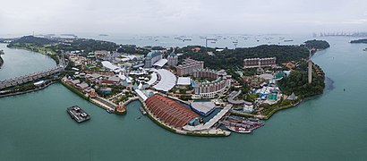
Sentosa Address: Sentosa, Singapore 099081 street in Singapore

Sentosa, Singapore
Sentosa, SingaporeSentosa Island, known mononymously as Sentosa, is an island located off the southern coast of Singapore's main island. The island is separated from the main island of Singapore by a channel of water, the Keppel Harbour, and is adjacent to Pulau Brani, a smaller island wedged between Sentosa and the main island. Formerly used as a British military base and afterwards as a Japanese prisoner-of-war camp, the island was renamed Sentosa in the 1970s to become a popular tourist destination. It is now home to a popular resort that receives up to 25 million visitors per year. Attractions include a 2.5 km (1.6 mi) long sheltered beach, Madame Tussauds Singapore, an extensive cable car network, Fort Siloso, two golf courses, 14 hotels as well as the Resorts World Sentosa, which features the Universal Studios Singapore theme park and one of Singapore's two casinos, the other being in Marina Bay Sands. Sentosa is also widely known as being the location of the 2018 North Korea–United States Singapore Summit, where North Korean Chairman Kim Jong-un and U.S. President Donald Trump met at the Capella Singapore located on the island. This was the first-ever meeting between the leaders of North Korea and the United States. As an island geared towards recreation and tourism with its casino and resorts under a tropical climate, as well as residences for the wealthy, Sentosa is more than twice the size of Monaco.
How to get to Sentosa with public transport- About the place

Get around Singapore by public transport!

Travelling around Singapore has never been so easy. See step by step directions as you travel to any attraction, street or major public transport station. View bus and train timetables, arrival times, service alerts and detailed routes on a map, so you know exactly how to get to anywhere in Singapore.

When travelling to any destination around Singapore use Moovit's Live Directions with Get Off Notifications to know exactly where and how far to walk, how long to wait for your line , and how many stops are left. Moovit will alert you when it’s time to get off — no need to constantly re-check whether yours is the next stop.

Wondering how to use public transport in Singapore or how to pay for public transport in Singapore? Moovit public transport app can help you navigate your way with public transport easily, and at minimum cost. It includes public transport fees, ticket prices, and costs. Looking for a map of Singapore public transport lines? Moovit public transport app shows all public transport maps in Singapore with all metro or bus routes and stops on an interactive map.

Singapore has 2 transport type(s), including: metro or bus, operated by several transport agencies, including SMRT, SBS Transit, SMRT, MRT/LRT Replacement Services, SBS Transit, SBS Transit, SMRT, Tower Transit, Go-Ahead Singapore, Premium Bus, City Direct Bus, Changi Airport, Sentosa Development Corporation, Sentosa Development Corporation and Cross Border Bus

Public transport routes with stations closest to Sentosa in Singapore

Metro lines with stations closest to Sentosa in Singapore

Bus lines with stations closest to Sentosa in Singapore

Ferry lines with stations closest to Sentosa in Singapore

Cable Car lines with stations closest to Sentosa in Singapore

Easier to get to Sentosa in…