Directions to Shettleston (Glasgow) with public transport
The following transport lines have routes that pass near Shettleston
How to get to Shettleston by bus?
Click on the bus route to see step by step directions with maps, line arrival times and updated time schedules.
How to get to Shettleston by train?
Click on the train route to see step by step directions with maps, line arrival times and updated time schedules.
Bus stations near Shettleston in Glasgow
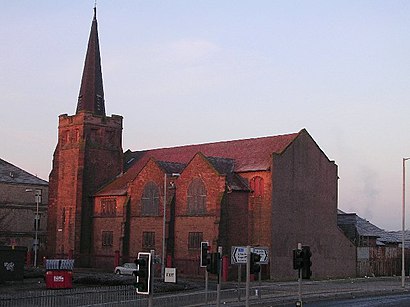
- Eastbank Church, Shettleston,2 min walk,
- Shettleston Railway Station, Greenfield,4 min walk,
- Fenella Street, Shettleston,5 min walk,
- Duke Street,18 min walk,
Bus lines to Shettleston in Glasgow
- 310,Gartcosh,
- 46,Easterhouse,
- 46,Queenslie,
- 60,Clydebank,
- 60A,Castlemains,
- 2,Faifley,
- N2,Easterhouse,
- SCOTRAIL,Helensburgh Central,
What are the nearest stations to Shettleston?
The nearest stations to Shettleston are:
- Eastbank Church, Shettleston is 78 meters away, 2 min walk.
- Shettleston Railway Station, Greenfield is 216 meters away, 4 min walk.
- Fenella Street, Shettleston is 333 meters away, 5 min walk.
- Duke Street is 1365 meters away, 18 min walk.
Which bus lines stop near Shettleston?
These bus lines stop near Shettleston: 2, 60.
Which train line stops near Shettleston?
SCOTRAIL
What’s the nearest bus stop to Shettleston in Glasgow?
The nearest bus stop to Shettleston in Glasgow is Eastbank Church, Shettleston. It’s a 2 min walk away.
What time is the first train to Shettleston in Glasgow?
The SCOTRAIL is the first train that goes to Shettleston in Glasgow. It stops nearby at 08:11.
What time is the last train to Shettleston in Glasgow?
The SCOTRAIL is the last train that goes to Shettleston in Glasgow. It stops nearby at 22:28.
What time is the first bus to Shettleston in Glasgow?
The N2 is the first bus that goes to Shettleston in Glasgow. It stops nearby at 03:35.
What time is the last bus to Shettleston in Glasgow?
The 2 is the last bus that goes to Shettleston in Glasgow. It stops nearby at 00:42.
See Shettleston, Glasgow, on the map
Public Transit to Shettleston in Glasgow
Wondering how to get to Shettleston in Glasgow, United Kingdom? Moovit helps you find the best way to get to Shettleston with step-by-step directions from the nearest public transit station.
Moovit provides free maps and live directions to help you navigate through your city. View schedules, routes, timetables, and find out how long does it take to get to Shettleston in real time.
Looking for the nearest stop or station to Shettleston? Check out this list of stops closest to your destination: Eastbank Church; Shettleston Railway Station; Fenella Street; Duke Street.
Bus:260310464660AN2SCOTRAILTrain:SCOTRAIL
Want to see if there’s another route that gets you there at an earlier time? Moovit helps you find alternative routes or times. Get directions from and directions to Shettleston easily from the Moovit App or Website.
We make riding to Shettleston easy, which is why over 1.5 million users, including users in Glasgow, trust Moovit as the best app for public transit. You don’t need to download an individual bus app or train app, Moovit is your all-in-one transit app that helps you find the best bus time or train time available.
For information on prices of bus and train, costs and ride fares to Shettleston, please check the Moovit app.
Use the app to navigate to popular places including to the airport, hospital, stadium, grocery store, mall, coffee shop, school, college, and university.
Shettleston Address: Balgair Terrace street in Glasgow
Shettleston (Scots: Shuttlestoun, Scottish Gaelic: Baile Nighean Sheadna) is a district in the east end of Glasgow in Scotland.Wiki
Attractions near Shettleston
Shettleston,Shettleston,Millers Bar and Bistro,Budhill,Balfour Beatty Rail Pci Office,Eagley Plastics,Budhill Avenue,Budhill Medical Practice,Annick Industrial Estate,Scotmid,6 Sandilands Street,D M H Electrical Services,African Food Supplies,Shettleston Tesco,TWG,Meg McHugh Entertainment Limited,The Rowan Tree,Frankie's Flowers,The Florist SH,Platinum European BatteriesHow to get to popular attractions in Glasgow with public transportation
Exhibition Centre Railway Station (EXG), Glasgow,Langside, Glasgow,Dunfermline, Dunfermline,Glasgow Airport (GLA), Paisley,River Clyde, Glasgow City,EICC, Edinburgh,Western General Hospital (Edinburgh), Edinburgh,South Queensferry, Queensferry,CodeBase, Edinburgh,Virgin Active, Glasgow,The Queens Arms, Edinburgh,Perth Railway Station (PTH), Perth,Brandon Parade, Motherwell,Fort William, Fort William,Thornliebank, Thornliebank,Scottish Event Campus (SEC), Glasgow,Peebles, Peebles,IKEA, Glasgow,Scottish National Gallery, Edinburgh,Edinburgh Christmas Market, EdinburghGet around Glasgow by public transport!
Travelling around Glasgow has never been so easy. See step by step directions as you travel to any attraction, street or major public transport station. View bus and train timetables, arrival times, service alerts and detailed routes on a map, so you know exactly how to get to anywhere in Glasgow.
When travelling to any destination around Glasgow use Moovit's Live Directions with Get Off Notifications to know exactly where and how far to walk, how long to wait for your line , and how many stops are left. Moovit will alert you when it’s time to get off — no need to constantly re-check whether yours is the next stop.
Wondering how to use public transport in Glasgow or how to pay for public transport in Glasgow? Moovit public transport app can help you navigate your way with public transport easily, and at minimum cost. It includes public transport fees, ticket prices, and costs. Looking for a map of Glasgow public transport lines? Moovit public transport app shows all public transport maps in Glasgow with all bus or train routes and stops on an interactive map.
Glasgow has 2 transport type(s), including: bus or train, operated by several transport agencies, including First Greater Glasgow, First Aberdeen, Lothian Buses, McGill's Bus Service, Stagecoach East Scotland, Stagecoach Bluebird, Xplore Dundee, Community Transport Glasgow, Prentice Westwood, McCall's Coaches, J P Minibus, National Rail, R Robertson & Son, Burnbrae Garage and Ember