See Shipstone's, Nottingham, on the map
Directions to Shipstone's (Nottingham) with public transport
The following transport lines have routes that pass near Shipstone's
 Bus:
Bus: - Light rail:
How to get to Shipstone's by bus?
Click on the bus route to see step by step directions with maps, line arrival times and updated time schedules.
Bus stations near Shipstone's in Nottingham
- Bar Lane, Basford (Ba29),3 min walk,
- Basford Crossing, Basford (Ba07),6 min walk,
- Vernon Road, Basford (Ba82),7 min walk,
- Radford Road, Whitemoor (Wm10),7 min walk,
- Futurist, Basford (Ba17),8 min walk,
Light Rail stations near Shipstone's in Nottingham
- Basford Tram Stop, Basford,4 min walk,
Bus lines to Shipstone's in Nottingham
- 70,Nottingham,
- 70B,Bulwell,
- 71,Bulwell,
- 71B,Cinderhill,
- 68,Nottingham,
- 68A,Nottingham,
- 69,Nottingham,
- 68B,Bulwell,
- 69A,Snape Wood,
- A2,Beechdale,
- 53,Arnold,
- 54,Clifton,
- 53B,Lenton Lane Industrial Estate,
What are the nearest stations to Shipstone's?
The nearest stations to Shipstone's are:
- Bar Lane, Basford (Ba29) is 214 meters away, 3 min walk.
- Basford Tram Stop, Basford is 234 meters away, 4 min walk.
- Basford Crossing, Basford (Ba07) is 387 meters away, 6 min walk.
- Vernon Road, Basford (Ba82) is 482 meters away, 7 min walk.
- Radford Road, Whitemoor (Wm10) is 526 meters away, 7 min walk.
- Futurist, Basford (Ba17) is 528 meters away, 8 min walk.
Which bus line stops near Shipstone's?
528|NOTTSBUS CONNECT
Which light rail line stops near Shipstone's?
TRAM
What’s the nearest light rail station to Shipstone's in Nottingham?
The nearest light rail station to Shipstone's in Nottingham is Basford Tram Stop, Basford. It’s a 4 min walk away.
What’s the nearest bus stop to Shipstone's in Nottingham?
The nearest bus stop to Shipstone's in Nottingham is Bar Lane, Basford (Ba29). It’s a 3 min walk away.
What time is the first light rail to Shipstone's in Nottingham?
The TRAM is the first light rail that goes to Shipstone's in Nottingham. It stops nearby at 00:04.
What time is the last light rail to Shipstone's in Nottingham?
The TRAM is the last light rail that goes to Shipstone's in Nottingham. It stops nearby at 01:25.
See Shipstone's, Nottingham, on the map
Public Transit to Shipstone's in Nottingham
Wondering how to get to Shipstone's in Nottingham, United Kingdom? Moovit helps you find the best way to get to Shipstone's with step-by-step directions from the nearest public transit station.
Moovit provides free maps and live directions to help you navigate through your city. View schedules, routes, timetables, and find out how long does it take to get to Shipstone's in real time.
Looking for the nearest stop or station to Shipstone's? Check out this list of stops closest to your destination: Bar Lane; Basford Tram Stop; Basford Crossing; Vernon Road; Radford Road; Futurist.
Bus:Light rail:
Want to see if there’s another route that gets you there at an earlier time? Moovit helps you find alternative routes or times. Get directions from and directions to Shipstone's easily from the Moovit App or Website.
We make riding to Shipstone's easy, which is why over 1.5 million users, including users in Nottingham, trust Moovit as the best app for public transit. You don’t need to download an individual bus app or train app, Moovit is your all-in-one transit app that helps you find the best bus time or train time available.
For information on prices of light rail and bus, costs and ride fares to Shipstone's, please check the Moovit app.
Use the app to navigate to popular places including to the airport, hospital, stadium, grocery store, mall, coffee shop, school, college, and university.
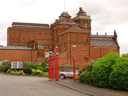
Shipstone's Address: Old Basford Nottingham NG6 0 street in Nottingham
James Shipstone & Sons was a brewery in New Basford, Nottingham, England, that opened in 1852 and closed in 1991.Wiki
Attractions near Shipstone's
R B Lindley,Gosal Motors,Old Basford,Lindley's,B M C,Basford M O T Centre,Lindleys Vehicle Sales,Themotorbase Limited,SBS 2000,Yves-Alain,Eastgate Cares,Little Star Brewery,Reunion Pub Company,Lee and Fletcher,Church Street Garage,D & J Projects,Bespokee,KBL Fabrication & Engineering,Nottingham Alignment,Shop 7How to get to popular attractions in Nottingham with public transportation
Virgin Active, Northampton,Lidl, Peterborough,Tesco Extra, Leicester,Ideal World Studios, Peterborough,Experian Embankment House, Nottingham,Bilborough College, Nottingham,Holiday Inn Express Peterborough, Peterborough,Donut Roundabout Car Park, Chesterfield,Memsaab Restaurant, Nottingham,Nando's, Kettering,Market Warsop, Mansfield,Burton Latimer, Kettering,De Montfort University, Leicester,Currys PC World, Nottingham,Nottingham Station, Nottingham,Tesco Hamilton Petrol Station, Leicester,British Gas Museum, Leicester,YBS Group - Lynch Wood, Peterborough,Quorn & Woodhouse Railway Station (GC Railway), Charnwood,Sherwood, NottinghamGet around Nottingham by public transport!
Travelling around Nottingham has never been so easy. See step by step directions as you travel to any attraction, street or major public transport station. View bus and train timetables, arrival times, service alerts and detailed routes on a map, so you know exactly how to get to anywhere in Nottingham.
When travelling to any destination around Nottingham use Moovit's Live Directions with Get Off Notifications to know exactly where and how far to walk, how long to wait for your line , and how many stops are left. Moovit will alert you when it’s time to get off — no need to constantly re-check whether yours is the next stop.
Wondering how to use public transport in Nottingham or how to pay for public transport in Nottingham? Moovit public transport app can help you navigate your way with public transport easily, and at minimum cost. It includes public transport fees, ticket prices, and costs. Looking for a map of Nottingham public transport lines? Moovit public transport app shows all public transport maps in Nottingham with all light rail or bus routes and stops on an interactive map.
Nottingham has 2 transport type(s), including: light rail or bus, operated by several transport agencies, including National Rail, Ashbourne Community Transport, Delaine Buses, Arriva Midlands, Centrebus, Our Centre, Hulleys of Baslow, D & G Bus, Stagecoach East Midlands, North Lincolnshire Council, National Rail, Roberts Coaches, Lawson's of Corby, Hawkes Coaches and East Yorkshire